Just a stones throw from downtown Prescott (an easy 6 mile drive), Granite Basin is a gorgeous section of the Prescott National Forest. Here, you can choose from more than a half dozen hikes.
Normally, I’d opt for the higher ground and head up Little Granite Mountain, but the day I visited was a scorcher. I chose an easy out and back on one of the lower creek-side trails, hoping that the ponderosa pines would shelter me from the blazing sun. Even with the shade, it was still HOT, too hot for hiking. And since I’d already beat myself up on the mountain bike at Goldwater Lake that morning, my mojo was a bit sapped too.
Granite Basin is home to a wide variety of wildlife, including snakes, lizards, coyotes, foxes, mountain lions. I didn’t see any of these critters most likely because they were all in siesta mode as I probably should have been too. Thinking back on it, a hammock under a shady tree by the lake with a refreshing beverage would have been made for an idyllic afternoon.
It was a pleasant hike, but not particularly scenic per se, except for the start and finish at stunning Granite Basin Lake. And I must say, it’s a bit tortuous on a hot day to look at a beautiful lake and be prohibited from jumping in it. Guess that’s mostly the case in Arizonia…Bummer, I guess you can’t have everything. I did spend some time on this hike day dreaming or hallucinating (not sure which) about my Eastern Sierra’s splash in Valentine Lake.
I’d like to come back to this area sometime when it’s cooler to explore some more and take in the views from Little Granite Mountain. And next time, maybe I’ll bring a hammock for that post-hike siesta too.
Ok, some adventures just don’t go as planned. This was one of those. I spent at least 35 minutes hike-a-biking trying to find the mountain bike trail. Granted someone with better technical skills than me (just about anyone) probably could have biked much of what I had hiked. At one point, my phone fell out my bike jersey without my knowing. (Luckily, when I retraced my steps I found it with the screen in tact—thank goodness.) That’s how it started.
I’m sure Han’s No Way Rey and Missy Giove, the MTB legends I met on my Catalina mountain bike adventure would have popped over this little bridge no problem— not me.
When I finally jumped on the single track trail I’d originally intended, I had to keep jumping off the bike to navigate over rocks or roots.
My downfall When the trail opened up into a rough fire road, I thought, Ok, this should be doable for me now. Well, apparently not. After another 35 minutes of navigating loose gravel and pot holes, my tire slipped out from under me and I wiped out and landed hard
Sometimes knowing when to surrender is better than ruining your vacation or life with an injury, especially if you’re out there alone as I was. Sure I was tempted to get my bruised butt back on the bike and see where the bumpy fire road would take me, but I had a work conference call coming up and other places to explore on foot before nightfall anyway. Was glad that I didn’t have my Garmin to tell me how few miles I’d covered. After I wiped the dust off my backside, I pedaled away, grateful for the climb up the hill back to the car (at least a partial workout).
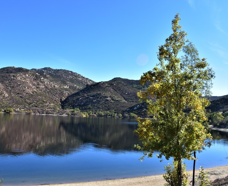
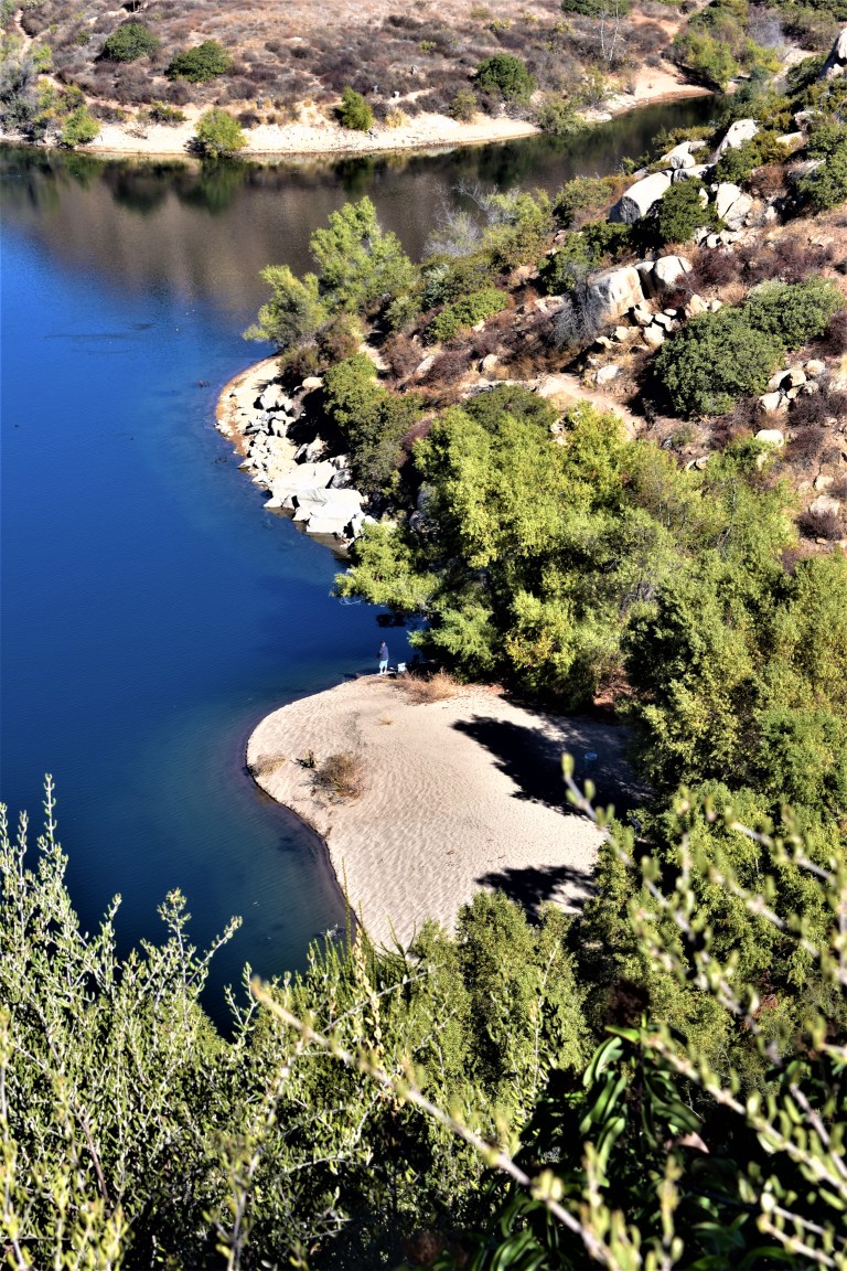
I didn’t run into any hikers or other mountain bikers, but there were about half a dozen people fishing at the lake. (None of whom knew the surrounding trails.) From what I can tell, 15-acre Goldwater Lake is a good spot for a family outing with summer kayak and canoe rentals, picnic tables, a playground, a horse shoe pit and a volleyball court. You’ll have to ask someone else about the trails.
Long story short, that’s why I only skimmed the surface of what the Goldwater Lake trails offer. I’ll give it another shot if I return to the area (most likely by foot or with a mountain biker that knows the trails).
Getting there: 2900 S. Goldwater Lake Road, from Prescott,go south on Mount Vernon Street, which becomes Senator Highway.
Fee: $3 for Parking
Ever had an adventure that just didn’t go as planned? Share your experience.
Stay tuned for my top picks of places to stay and eat and for more of my active escapades in and around Prescott.
Cowles Mountain (1,593-foot summit) is the highest point in the city of San Diego. It’s part of Mission Trails Regional Park, a 5,800-acre open space preserve that is the 7th-largest open space urban park in the United States. It contains sixty miles of hiking, mountain bike and equestrian trails.
To call Cowles a mountain is to be very liberal with the word. I should note that the park has a 5 “peak” challenge if your hiking peeps want a minor challenge and want to document your feats – here’s the scoop. Cowles is the highest peak. This might be fun for kids, but apparently lots of adults do it for bragging rights too. I will say that on a clear day, the stunning views span 360 degrees from Lake Murray, downtown San Diego, Point Loma, La Jolla, and Mexico and out across the glimmering Pacific to the San Carlos Islands. See feature picture above. (Unfortunately, I dropped my camera on a rock so I have limited pics.)
Distance: 2.9 miles up & back
It’s a very popular trail so expect lots of humans and their canines…There are a couple of different ways to reach the top from various starting points and parking lots. The hike itself is moderate (with some steeper sections that will get those calves & glutes burning). It’s decent workout, especially if you run it. There are single track trails and some fire road. It’s short from any direction so I explored up and down on a couple of trails and was a little disappointed that there wasn’t more to see. You can’t really get lost so do as much or as little as you like.
Getting there:
The main trailhead is in the San Carlos neighborhood on the corner of Golfcrest Drive and Navajo Road
Lovely Lake Murray
Since I didn’t quite get enough enough of a workout / nature fix, I decided to check out alluring Lake Murray Reservoir, also part of the Mission Trails Regional Park. I strolled the paved road that navigates around most of the lake stopping short of the dam (no access). It’s another popular spot – walkers, runners, bladders, and even road bikers aplenty (the latter seems silly to me, because the path / road is only 3.2 mi long and there are many children and dogs on it).
Lake Murray is a great spot for birdwatchers with abundant ducks, geese, and herons abound and about 149 bird species to observe. It’s a pleasant spot for a picnic too.
Go Fish
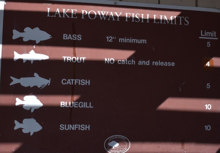
Lake Murray is open for shore fishing and private boats, kayaks, and float tubes seven days a week from 5:30 a.m. to 8:00 p.m. Permits can be purchased onsite at the iron ranger boxes. The lake is stocked with Florida-strain largemouth bass, bluegill, channel catfish, black crappie, and trout. Minimum size limit for bass is 12 inches.
Fish limits: 5 trout, 5 bass (min. 12 inches), 5 catfish, 25 crappie and bluegill total, no other species limits
Difficulty: Moderate + (Depends on your fitness level and the weather (heat/sun factor)
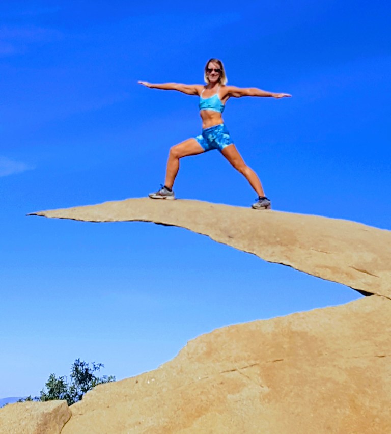
No, the featured image is not Potato Chip Rock. It’s some cool unnamed split rock along the top of the trail with a great view out to the rocky playground below and Lake Romona.
If you’re looking for solitude, you won’t find it here. This is one of the most popular hikes in San Diego because of the iconic Potato Chip Rock and obligatory photo op at the top.
Spoiler alert.
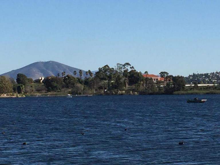
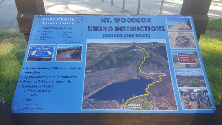
The trail starts at Lake Poway and leads you up a fire road for a mile or so before it narrows and steepens.
And the answer is yes, you can fish in Lake Poway. Sadly, swimming is not allowed.
Here’s the scoop
The view of the lake is lovely from the trail above. You can see how clean and clear the water is.
The view from the top depends on how clear of a day it is. Unfortunately, it was a bit hazy, In the picture below, you can make out Point Loma and the Pacific in the distant horizon on the right and the high rises of San Diego to the left of it.
.
Another cool spot along the trail – my rock throne
So yes, lots of highlights and a great workout. (I hike fast and made it up in an hour and 15min – down in 1hour 5.min.) The downhill gets my knees. There were a number of people using poles. The downside of this hike is way too many humans, but what do you expect from a cool hike near a city? If I ever do it again, I’m going for dawn patrol. The parking lot opens at 6AM for early birds who enjoy more solitude and sunrises.
Because this hike didn’t quite sate my appetite for nature and solitude, after lunch I went up the road to the Blue Sky Ecological Reserve and hiked up to Lake Ramona.
Headed to Palomar Mountain with hiking in mind and got much more out of the excursion than expected.
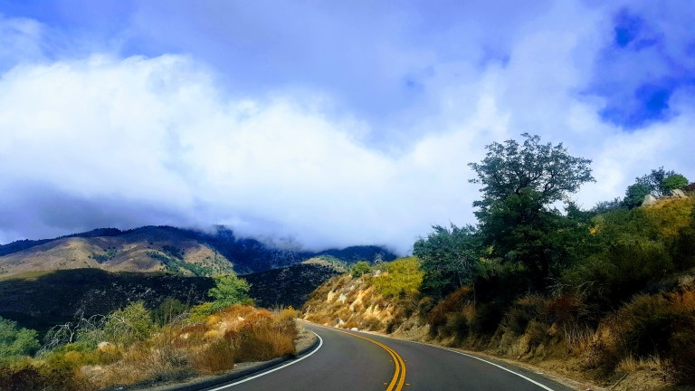
The drive up the South Grade (S6) mountain road is winding and scenic. You’ll want to keep your eyes on the road if you’re driving. Apparently this road has been compared to the L’Alpe d’Huez on the Tour de France Route so it’s popular with road cyclists, motorcyclists and sports car drivers too… Beware of those dare devil motocyclists crossing the center line as they race down the mountain
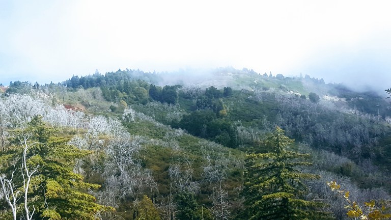
The clouds and fog made for some dramatic vistas on the way up.
The small park headquarters has a mini natural history exhibit. I didn’t know we had gray fox around here. Signs were up about a recent mountain lion sighting in the park.
Hiking Scoop
As far as the hiking here goes, most trails are short and dogs aren’t allowed on them. We did the longest loop we could find, starting at the Doane Pond, which is open for fishing year round and stocked with trout. It’s a great spot for a picnic too.
Overall, the terrain is easy on the feet – mostly dirt, not too many rocks or roots. It’s ideal for a quick trail run. (Note the seasonal tick and rattle snake warnings.)
We went up the Thunder Springs and the Silver Crest Trails and down Scott’s Cabin Trail and Chimney Flats. (Spoiler alert – the trails name is a misnomer as there is no standing cabin, just a placard at the site with no historic details on it or in the park’s brochure). The hike is interrupted by the road a couple times and the road is always within a stones throw. The good news – you won’t get lost. The bad news, if you’re a hiking snob like me, it’s a bit anticlimactic, but that’s ok – the views along the ridge, at the Boucher Hill Fire Tower, and by the Observatory are quite epic. And the road and the drive by locations make it accessible for all.
Here’s a video clip of a particularly lovely section of trail.
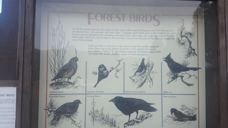
Tree lovers will delight in the variety that this section of the Cleveland National Forest yields: Douglass fir, white fir, incense cedar, live oak, black oak, coulter pine and yellow pine. Approximately 40 inches of annual rainfall keeps them thriving. Of course all these trees make it a haven for birds and bird lovers as well.
We saw all but the quail today.
Camping Scoop
The Doane valley Campground has 31 campsites, each outfitted with a table, fire ring, BBQ and food locker. Nearby restrooms have flush toilets and coin-operated hot showers. Many comforts of home in a forest setting – great for an introduction to camping. The Cedar Grove Campground has 3 areas for group camping. For more info and to reserve a spot up to 7 months in advance call 1-800-444-7275.
Enjoy Epic Views from the Boucher Hill Historic Fire Tower
The Boucher Hill Historic Fire Tower is definitely worth a stop too – whether you drive by or hike the 1.2 miles up from the visitor center. This is one of only 2 fire towers left in California. From the observation deck, you don’t even have to use the provided binocular gizmo to see the glimmering Pacific ~50 miles away.
This slideshow requires JavaScript.
Even with my bad eyes, I could make out Tamarack Tower / Smoke Stack that marks my home beach. You have to know what to look for to make it out in the video, but you can definitely tell that you’re looking out to sea.
Visit the Impressive Palomar Observatory & Museum
And no, the field trip’s not over yet. Next, we headed over to the Palomar Observatory. The structure itself is quite impressive (see feature photo), but it’s definitely worth looking inside. (Hours are 9-4 daily.) The Hale Telescope is considered one of most important scientific innovations of the last century and was the most productive and prominent telescope in the world from 1948 to 1993.
This slideshow requires JavaScript.
Don’t miss the Museum either. It’s got great displays, info and videos. The small gift shop was closed as we got there late, but I’m sure there’s some cool stuff and souvenirs for the kids in there too.
If you aren’t an astronomy or science buff going in, you might be when you leave. ..
So many fun things to do, see and learn here. Highly recommend Palomar Mountain as a field trip for the whole family. Great way to spend a Sunday afternoon.
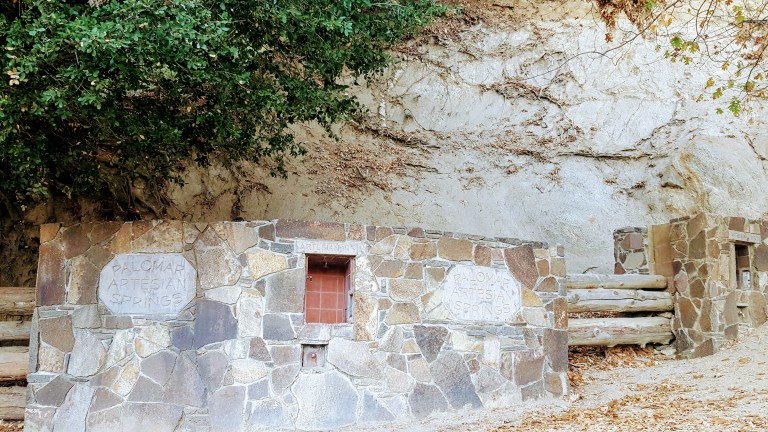
Almost forgot to mention, be sure to bring a water bottle and get your fill of refreshing fresh (and free) spring water on the way up or down at the Palomar Artesian Springs.


 My downfall When the trail opened up into a rough fire road, I thought, Ok, this should be doable for me now. Well, apparently not. After another 35 minutes of navigating loose gravel and pot holes, my tire slipped out from under me and I wiped out and landed hard