Peaceful Blue Sky Ecological Reserve, a 700 acre canyon, is a welcome reprieve from the over-populated Mt. Woodson trail. I’d had enough of the crowds, but not enough of nature and workout so after lunch at a nearby Mexican cantina, I followed up the Mt. Woodson hike with this one.
Distance: 4.8 RT Difficulty: Moderate ++ It’s all mild and friendly until you get the last half mile’s fierce grade, which is paved. Overall, the terrain itself is easy (fire road primarily) so it’s a great spot for trail running.
Trail advisory: It’s exposed so equip yourself with sunscreen and water rations. Also, you could be sharing the trail with bees, mountain lions, mosquitoes, poison oak, rattlesnakes & ticks (Friendlier potential trail mates include: deer, bobcats, quail, raptors, roadrunners, coyotes, squirrels, rabbits, and bats.)
This slideshow requires JavaScript.
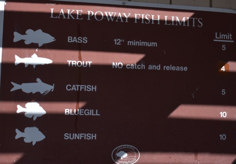
And yes, you can fish at Lake Ramona Reservoir. While bite-friendly, the huge bass population here is comprised of small largemouth because few fisherpeople want to hike up that great big hill. (Did I get enough size comparison in there to make your head spin?) Unfortunately, the bass overpopulation results in their stunted growth. Come on fisher peeps, work for it! You’re missing a beautiful opportunity. Besides, where’s the fun in driving up and parking at Lake Poway?
Lake Ramona was lovely and the reserve was pleasant enough though small. Personally, I wouldn’t go out of my way to get here, but if you’re in the neighborhood – do it.
Difficulty: Moderate + (Depends on your fitness level and the weather (heat/sun factor)
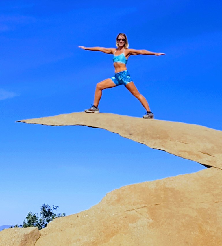
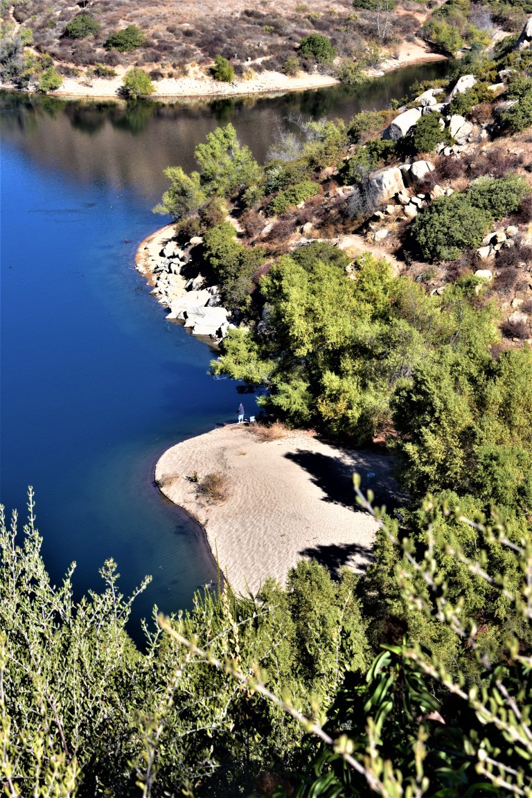
No, the featured image is not Potato Chip Rock. It’s some cool unnamed split rock along the top of the trail with a great view out to the rocky playground below and Lake Romona.
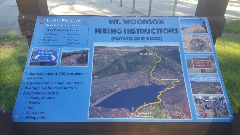
If you’re looking for solitude, you won’t find it here. This is one of the most popular hikes in San Diego because of the iconic Potato Chip Rock and obligatory photo op at the top.
Spoiler alert.
The trail starts at Lake Poway and leads you up a fire road for a mile or so before it narrows and steepens.
And the answer is yes, you can fish in Lake Poway. Sadly, swimming is not allowed.
Here’s the scoop
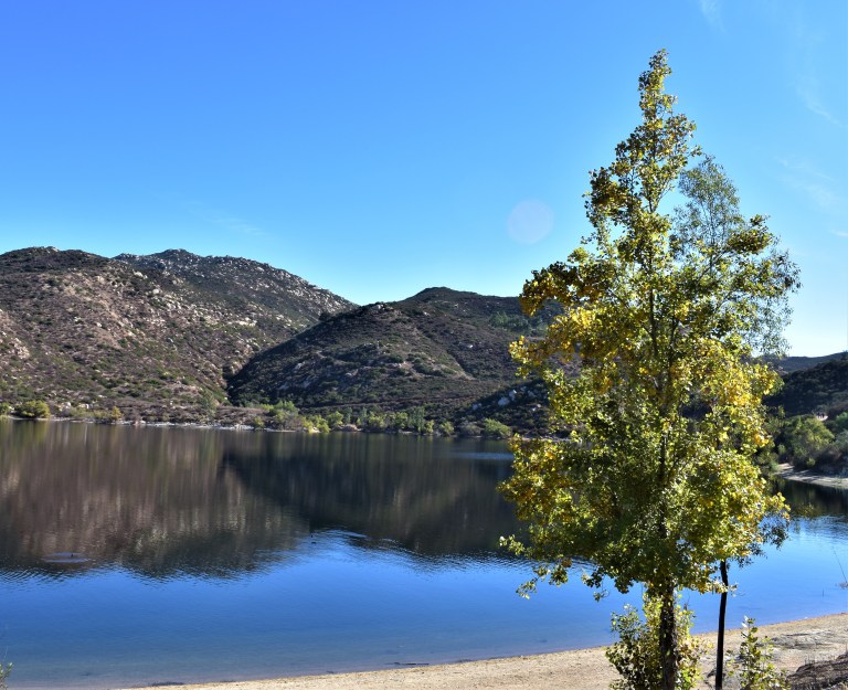
The view of the lake is lovely from the trail above. You can see how clean and clear the water is.
The view from the top depends on how clear of a day it is. Unfortunately, it was a bit hazy, In the picture below, you can make out Point Loma and the Pacific in the distant horizon on the right and the high rises of San Diego to the left of it.
.
Another cool spot along the trail – my rock throne
So yes, lots of highlights and a great workout. (I hike fast and made it up in an hour and 15min – down in 1hour 5.min.) The downhill gets my knees. There were a number of people using poles. The downside of this hike is way too many humans, but what do you expect from a cool hike near a city? If I ever do it again, I’m going for dawn patrol. The parking lot opens at 6AM for early birds who enjoy more solitude and sunrises.
Because this hike didn’t quite sate my appetite for nature and solitude, after lunch I went up the road to the Blue Sky Ecological Reserve and hiked up to Lake Ramona.
Headed to Palomar Mountain with hiking in mind and got much more out of the excursion than expected.
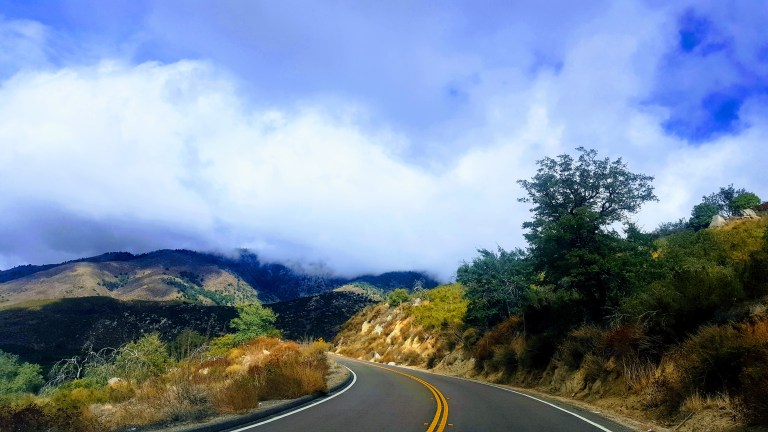
The drive up the South Grade (S6) mountain road is winding and scenic. You’ll want to keep your eyes on the road if you’re driving. Apparently this road has been compared to the L’Alpe d’Huez on the Tour de France Route so it’s popular with road cyclists, motorcyclists and sports car drivers too… Beware of those dare devil motocyclists crossing the center line as they race down the mountain
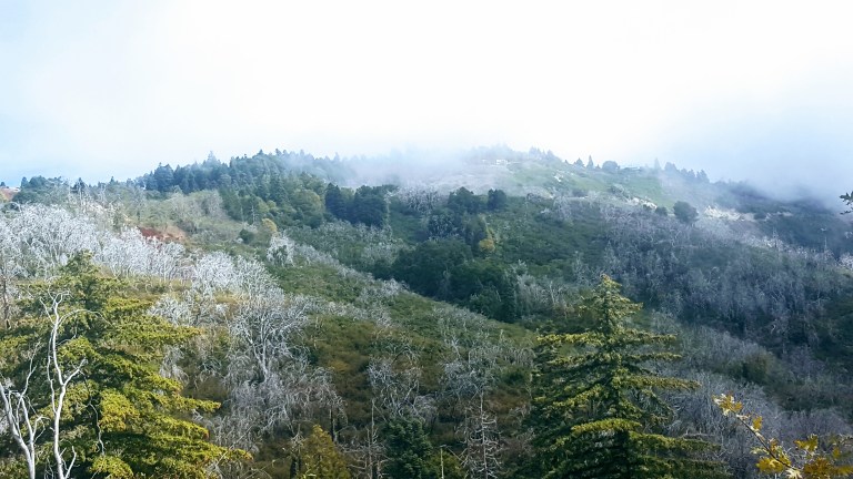
The clouds and fog made for some dramatic vistas on the way up.
The small park headquarters has a mini natural history exhibit. I didn’t know we had gray fox around here. Signs were up about a recent mountain lion sighting in the park.
Hiking Scoop
As far as the hiking here goes, most trails are short and dogs aren’t allowed on them. We did the longest loop we could find, starting at the Doane Pond, which is open for fishing year round and stocked with trout. It’s a great spot for a picnic too.
Overall, the terrain is easy on the feet – mostly dirt, not too many rocks or roots. It’s ideal for a quick trail run. (Note the seasonal tick and rattle snake warnings.)
We went up the Thunder Springs and the Silver Crest Trails and down Scott’s Cabin Trail and Chimney Flats. (Spoiler alert – the trails name is a misnomer as there is no standing cabin, just a placard at the site with no historic details on it or in the park’s brochure). The hike is interrupted by the road a couple times and the road is always within a stones throw. The good news – you won’t get lost. The bad news, if you’re a hiking snob like me, it’s a bit anticlimactic, but that’s ok – the views along the ridge, at the Boucher Hill Fire Tower, and by the Observatory are quite epic. And the road and the drive by locations make it accessible for all.
Here’s a video clip of a particularly lovely section of trail.
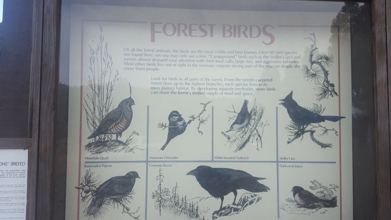
Tree lovers will delight in the variety that this section of the Cleveland National Forest yields: Douglass fir, white fir, incense cedar, live oak, black oak, coulter pine and yellow pine. Approximately 40 inches of annual rainfall keeps them thriving. Of course all these trees make it a haven for birds and bird lovers as well.
We saw all but the quail today.
Camping Scoop
The Doane valley Campground has 31 campsites, each outfitted with a table, fire ring, BBQ and food locker. Nearby restrooms have flush toilets and coin-operated hot showers. Many comforts of home in a forest setting – great for an introduction to camping. The Cedar Grove Campground has 3 areas for group camping. For more info and to reserve a spot up to 7 months in advance call 1-800-444-7275.
Enjoy Epic Views from the Boucher Hill Historic Fire Tower
The Boucher Hill Historic Fire Tower is definitely worth a stop too – whether you drive by or hike the 1.2 miles up from the visitor center. This is one of only 2 fire towers left in California. From the observation deck, you don’t even have to use the provided binocular gizmo to see the glimmering Pacific ~50 miles away.
This slideshow requires JavaScript.
Even with my bad eyes, I could make out Tamarack Tower / Smoke Stack that marks my home beach. You have to know what to look for to make it out in the video, but you can definitely tell that you’re looking out to sea.
Visit the Impressive Palomar Observatory & Museum
And no, the field trip’s not over yet. Next, we headed over to the Palomar Observatory. The structure itself is quite impressive (see feature photo), but it’s definitely worth looking inside. (Hours are 9-4 daily.) The Hale Telescope is considered one of most important scientific innovations of the last century and was the most productive and prominent telescope in the world from 1948 to 1993.
This slideshow requires JavaScript.
Don’t miss the Museum either. It’s got great displays, info and videos. The small gift shop was closed as we got there late, but I’m sure there’s some cool stuff and souvenirs for the kids in there too.
If you aren’t an astronomy or science buff going in, you might be when you leave. ..
So many fun things to do, see and learn here. Highly recommend Palomar Mountain as a field trip for the whole family. Great way to spend a Sunday afternoon.
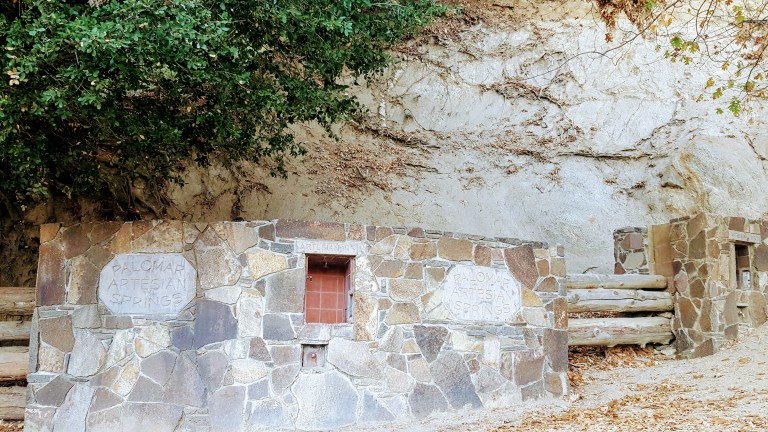
Almost forgot to mention, be sure to bring a water bottle and get your fill of refreshing fresh (and free) spring water on the way up or down at the Palomar Artesian Springs.
Wanted to make it to the lake and back. The trail is one of the best in the area with 11 waterfalls on the way. It was heavily wooded so the views of the waterfalls and the dramatic canyons and the cliffs weren’t always visible without a slight ramble on spur to the right.
Hiking distance: 11 miles round trip
Elevation gain: 1,900 feet
Unfortunately, the trail was heavily iced and snow-covered so I had to turn back at Chasm Falls about a mile and a half short of the lake. In the video below, I misnamed the hike Hyacinth – it is Hyalite. Must have been the brain freeze.
Error
This video doesn’t exist
Here’s a close up of the icicles by the falls.
By the way, do you think my jacket is bright enough? I’m hoping the hunters will too. Heard a couple shotgun shots on the way down. Ended the hike via the accessible and lovely 1.5 mile Grotto Falls trail.
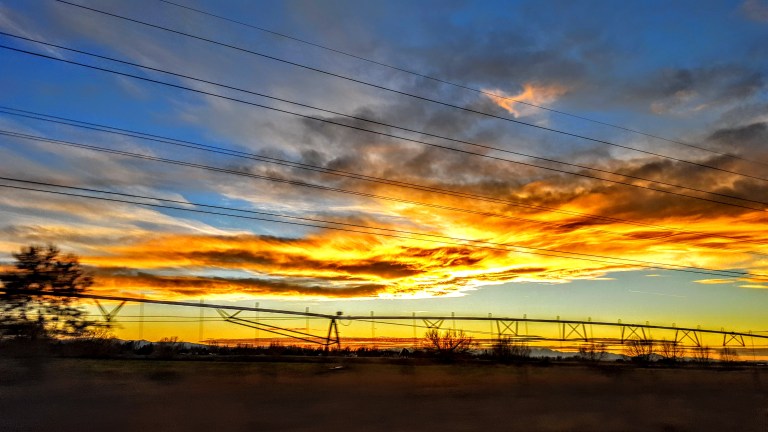
Ah, closing a day of hiking with a great meal at Ted’s Montana Grill and a big sky sunset, does it get better than this?
What began as a collection of small mining claims, became a large and booming mining center in the 1900s. This is Butte, aka The Richest Hill on Earth.
Had time for a short stop at the Butte Visitor Center and for a quick hike in wilderness that’s just out of town. (You know my priorities after sitting in a car for most of the day.) Drove the city’s main drag up the hill to the historic district and back down. If you’re into mining, historic towns or fly fishing, you’ll want to make a stop in Butte…
Driving down the historic hill, Butte, MT
A side street off the top of the hill, Butte, MT
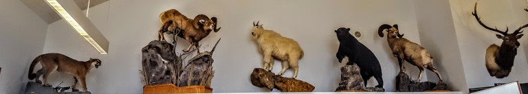
The visitor center had an extensive George Grant fly fishing exhibit and the requisite Montana taxidermy specimens/ natural history display.
We chose to hike in Thompson Park as hunters aren’t allowed in recreation areas, but they are everywhere else and it’s high season. Took the Pipestone Trailhead, which morphed into the Continental Divide Trail, and was rewarded with the vista in the feature photo at the top of the page. A pleasant way to end the day.
Next stop on this 10 day whirlwind road trip from Washington through Idaho and Montana: Bozeman