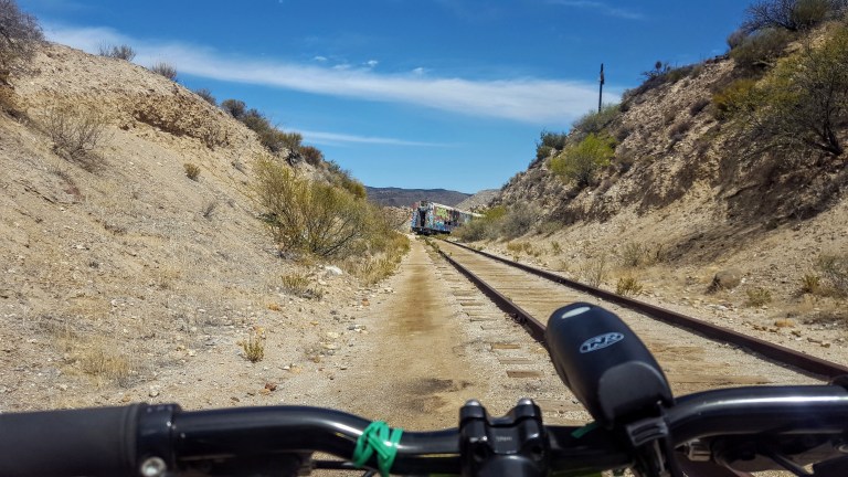
Deep in the heart of the Jacumba Mountains overlooking Carrizo Gorge in Anza Borrego State Park, you’ll find the Goat Canyon Trestle. Getting to the world’s largest curved wooden trestle is like being transported to the wild west of days done by. You’ll traverse dark tunnels in various stages of collapse, dodge rock slides, narrowly avoid precipitous drops into rock canyons, explore abandoned trains and endure the blazing desert sun. If this is your idea of fun, read on. Ok, it’s not that bad. In fact, it’s an easy, flat mtb cruise or a longish flat hike through some very cool (pun intended) desert terrain.
(Video credit and pics I’m in below: Ken Wells)
It’s slow going as there are several points where you have to lift your bike over one obstacle or another. You can’t speed through because you never know what’s around the next corner or if the bottom might drop out in front of you.
Be alert and cautious all the way out and back. Headlamps are a must for the tunnels, lots of obstacles in there. Workout-wise, it’s easy – safety-wise, it could be considered a bit sketchy.
As you bike along the railway, sometimes the path is quite narrow with a precipitous drop into the rocky canyon below. A moment of distraction could make for a very bad day. Wouldn’t suggest mountain biking for kids here, unless they are quite skilled and cautious riders.
Up close, the trestle seems a bit rickety, like a skinny, dilapidated Jenga set.
This slideshow requires JavaScript.
Background: The trestle was built in 1933, as part of the San Diego and Arizona Eastern Railway, aka “the impossible railroad” that ran through Baja California and Eastern San Diego County and ended in Imperial Valley. Over the years, collapsed tunnels and rock slides plagued the railroad, including the collapse of Tunnel 15, which led to the creation of the trestle. The trestle was constructed of wood (no nails used), rather than metal due to the area’s extreme temperature fluctuations, which can lead to “metal fatigue” / failure and it was designed with a 14 degree angle to offset Goat Canyon’s high winds. By 2008, rail traffic had ceased. As recently as last year, another tunnel, Number 6, near the trestle collapsed…(Yikes.)
Distance: Roundtrip 10 -14 miles, depending on where you start
Getting there: 8E from San Diego, take the Jacumba Exit
Parking: Park for free in the dirt lot right off the freeway at the Jacumba exit and follow the dirt portion of Carrizo Gorge Road 2 miles towards the DeAnza Spring Resort, the largest “clothing optional” resort in North America. Optionally, pay $5 to park at the resort. 1951 Carrizo Gorge Rd. There’s a Subway & gas station right off the freeway. You can also grab a bite & beer at the resort after your ride…
Note: This is the desert, plan accordingly – ample water, sunscreen, hat, etc…
Monserate Mountain is more of a steepish molehill than a mountain. You can hike, bike or run up the trail for a short, steep, incline workout and the reward of expansive views of the mountains (Agua Tibia, Red Mountain, Santa Ana Mountains), farmland in the valley below, and a sliver of Pacific Ocean way out to the west. I have mixed feeling about this one for reasons detailed below…
History
Monserate Mountain was part of an 13,323-acre Rancho Monserate Mexican Land Grant from 1853 that originally extended south and east of the present day Fallbrook down to the San Luis Rey River.
Pros
If you’re in or near the area, you can get a quick workout here with sweet 360 degree views at the top. Also, I think that it might be the right balance of tough and short for hardy hiker kids who get a feeling of accomplishment from doing something challenging.
There are a couple offshoot trails on the way up: Canoninta Trail and Red Diamond. I didn’t take those, but once at the top, headed south along a Ridge Trail to the water tank. This was the best part of the hike for me – it faced away from the freeway on a little stretch of single track with views into the valleys below and east across the mountain ridges. The Ridge Trail descends gradually with the help of a short wooden staircase and then drops you out on a paved road. (In the pic below, I turned around and ran up the staircase for the pure joy of a little more incline.)
Glutton for the incline.Mountains to the east from the Ridge Trail.
Cons
The barren, dirt trail going up has little to no aesthetic appeal. This trail gets lots of traffic, human and dog (too much I’d say). And I’m afraid it smells like it too. (I have a sensitive schnozz and the trail smelt like dog poop most of the way up.) Also read a review that someone got bitten by a dog twice on this trail. The roar of the 15 freeway below is also a bit off putting as are the weekend crowds that you have to hike around. (I was so uninspired and turned off by the dog poop smell, I didn’t take any pictures on the way up.) Yes, that bad – but then again, I’m a hiking snob. You’ll see why if you visit some of my other posts.
If you’re in the area, do it. Otherwise, I wouldn’t go too far out of your way for this one. Distance: 3.2 miles up and back without add ons, or 4.4 mile loop adding on the Ridge Trail loop to the water tank. Elevation gain /loss: ~1150 feet, moderately strenuous, depending on what shape you’re in. If you’re a trail runner, you’ll like it and you’ll want to add on the Ridge Trail water tank loop. Terrain: Mostly wide dirt path with rocks and some erosion, some single track, paved road & fire road if you do the 4.4 mile loop.
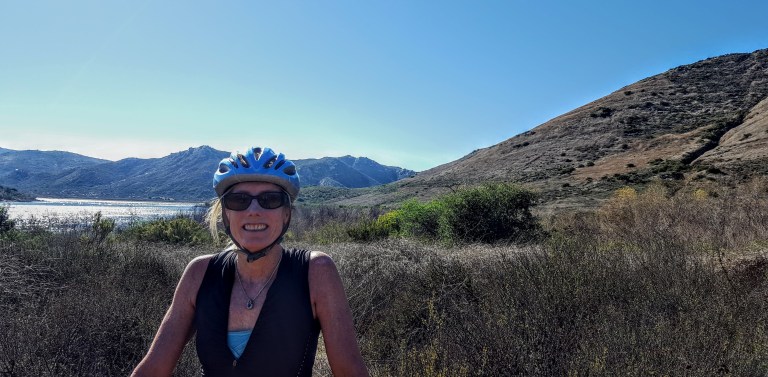
My back was a little tweaked from last week’s roller blade when I used my butt as a brake so I was looking for something mellow to do this weekend. That’s when I thought of mt.biking around Lake Hodges on the flat section of the San Dieguito River Park Coast to Crest Trail. This multi-use trail is open to hikers/runners, mountain bikers and equestrians. The main trail (a planned 70 miles – 45 miles of which currently exists ) extends from Del Mar to Volcan mountain in Julian. And there are over 20 miles of auxiliary trails within the River Park to play on.
I chose an easy cruise on a friendly wide dirt trail through the North side of the park. If you add on some single track on the flip side, you can make it around to the dam.)
(Option to stop in for some refreshments at Herandez Hidaway on Lake Drive.) We passed it up because my back was acting up (could have been the three falls). There are only about 3 spots where a mtb novice or clutz like me needs to walk (should have walked) hence the falls. Otherwise, super pleasant, beginner mtb trail. Managed to get about 16 miles in on the out and back.
Lake Hodges Dam in the DistanceSan Dieguito River Park Lake Hodges Bike & Pedestrian Bridge with Bernardo Mountain to the left.
I’ve ridden and run the South side too – not as much mileage there and much better views on the North side, in my opinion. If you’re tough and technical, you can go for the Bernardo Mountain Summit trail – looks fun. You can also find more trails under the pedestrian bridge, but you may encounter some challenging single track there. (I might hike a couple of these to scout them first and report back. I suspect they won’t be as scenic since they ride away from the lake.)
Other options to explore if you’re not afraid of some rugged single track
Getting there:
There are a number of ways to access the trails. The pedestrian / bike bridge is a good a starting point for explorations North or South.
I-15 freeway to West Bernardo/Pomerado Road, go west and park in the Bernardo Bay parking lot on the right just before Rancho Bernardo Community Park,
Or perhaps consider parking your car at Hernadez Hideaway on the other side of the lake so you can look forward to lunch and libations after your ride.
Hernadez Hideaway, 19320 Lake Drive Escondido, California 92029
As a triathlete, I’ve cycled the 30-mile Santa Ana River Trail on multiple occasions. Designated a National Recreation Trail in 1977, it’s the county’s longest cycling and walking trail, running from the Pacific Ocean at Huntington Beach to the Orange/Riverside county line. The vision, now lost, was to create the longest multi-use trail in Southern California with planned extensions to reach as far as Big Bear Lake in San Bernardino County.
Fairly bland for most of the ride, it starts to get pretty near the far end as you pedal along a park in the Anaheim Hills / Yorba Linda area. Here the river opens up to an oasis with green marshes and rolling water frequented by great blue and white herons, geese and other birds. On a clear day the San Gabriel Mountains reveal themselves as the alluring backdrop. If you squint just so, you can block out the concrete that frames the river and the traffic-jammed freeway on the other side. You might even imagine for a moment that you’re in Idaho or some other idyllic place.
Years ago, riding solo I passed a small group of homeless people by a restroom on the trail and remember feeling slightly uneasy. Recently, I heard on NPR that the police had cleaned up the area so I thought I’d give it go since I was going to Orange County for a friend’s 50th birthday party. I guess I should have done my research before I talked my boyfriend into doing the ride with me…
Since the last time I was there, the homeless population has exploded. There was zero evidence of any so called clean up. The area by Anaheim’s Angel Stadium is a wasteland with hundreds of tents and semi-permanent makeshift dwellings strewn on both sides of the bike lane and garbage everywhere. This goes on for a couple miles.
Homelessness is becoming as American as apple pie and baseball in a society where baseball players make millions and cities can’t help those in need or police their confines.
Who are these people? From what I’ve heard the population is a mix of felons, drug addicts and dealers, the mentally ill, veterans, illegal aliens, variations of all of the latter and other misfortunates. And yes, they are mothers, fathers, sisters, brothers and children.
Are they the new Bedouins or gypsies of 21st century? No, they aren’t nomadic or transient. Make no mistake about it; these squatters have set up homesteads here. They have claimed their corner of concrete, creating walls around their “property” with wooden crates , bamboo screening, solar panels and generators. Several camps fly the American flag and have garden chairs placed in front. Others are less hospitable with wooden “Keep Out” signs propped against the tarps that comprise multi-dwelling compounds. Even in homeless America, bigger appears to be better.
I was relieved to see a volunteer group organizing trash collection. As you can imagine, the path is littered with debris of every kind. A church group was there handing out containers of food. There were a couple of car batteries lined up outside tents along the trail – presumably someone charges them too. These services are doubled edged swords, clearly addressing needs while clearly encouraging the permanence of an untenable situation.
Beyond the main encampment strip that runs a couple miles, I saw a tall, older man emerge from a pop-up tent. He was well groomed and completely buttoned up in an oxford shirt and belted jeans, looking like he might be heading to work. He reminded me of my father.
My boyfriend wanted to turn back at the first signs of the squalor. He was concerned that we’d get a flat riding over scattered broken glass and be accosted. Since we’d gone that far, I wanted to hold out for the restorative glimpse of natural beauty at the end…
It’s obvious that the situation is entirely out of control. It’s unsafe and utterly unsanitary. It looks and smells like something from a post-apocalyptic movie, a version of 3rd world lawlessness ―all within walking and biking distance to a couple of Southern California’s wealthiest communities (Newport Beach, Anaheim Hills, Yorba Linda).
The “oasis” was greener than ever; the streaming water sparkling in the sun. The herons, egrets and geese were plentiful. We cycled by two fisherman, surprised when one of them reeled in a good size fish. It was as if we’d been transported to another time and place—an entirely different movie set.
We had 2 near misses on the ride. On the way out, a disheveled woman with 1 front tooth riding an expensive triathlon / time trail bike veered into the path at me from the side lines. Luckily, I was able to swerve and avoid a collision. The ghost of Christmas future or stolen goods? On the way back, I was behind three cyclists when we went under a bridge. In the darkness, a half naked man ran at us yelling something undecipherable. Luckily, the cyclists in front of me managed to maneuver around him. If I’d entered first, I’m not sure what would have happened. Thankfully, disasters averted.
Apparently, the lack of policing and the escalating homeless population are due to jurisdictional disputes between the Anaheim Police Department and the Orange County Sheriff Department. Whatever the case is, it’s absolutely appalling and a shocking reality of life in 21st century America. It’s hard to imagine this colossal problem being addressed effectively anytime soon while it’s easy to imagine it getting worse. This is another skid row in the making – one among many. (Homeless populations are increasing everywhere in California down the coast from Santa Barbara to Laguna Beach and San Diego.)
“Things fall apart; the centre cannot hold;
Mere anarchy is loosed upon the world…”
W. B. Yeats
For the record, I’m not unsympathetic to the plight of my fellow man and understand that a series of unfortunate events and / or choices can have a cataclysmic impact. We also know that the human spirit can overcome and rise above most events with and without help. Regardless of your perspective, it’s a complicated tragedy. Some might say it’s just one of the many signs of Western Civilization’s decline.
Too melodramatic? Perhaps. What I know is what I’d hoped would be a stress-free bike ride on the Santa Ana River Trail was anything but. I’ve been waiting for my epiphany from this experience – yes, gratitude for my privileged life and what else?
A deeper conviction that I need to live closer to nature somewhere beautiful and under-populated, far away from Southern California. Am I running away? Yes, as fast and as far away as I can. I know, places like Idaho and Montana have their problems too, but I can face them better when I’m breathing fresh air and am surrounded by pristine wilderness.
I thought if it were me, my tent would be under the trees at the oasis overlooking the marsh – far from everyone else. I’d be fine walking a couple miles to partake in the free food and trash services. I would not be flying the American flag.
Do you have a large homeless population where you live? What are your thoughts?
My camera battery died so I couldn’t take more pictures, which is probably just as well as it’s not a place you want to be loitering. It is something you have to see to believe. Below are a couple recent articles in the OC Register with pictures and stories that better capture the extent of the problem.
Better yet, here are 2 videos by fellow cyclists – not sure about the happy music soundtrack in the one or the snarky commentary in the other, but they provide a live picture:
Trailhead: 13852-, 13998 Jamul Drive, Jamul, CA 91935
~25 miles from downtown San Diego.Take 94 East, exit at Campo Road. Follow Campo Road for ~ 4.5 miles, turn left onto Lyons Valley Road and then left on Jamul Drive and you’ll see the dirt turnout / parking lot at 0.4 mile.Trail starts at the kiosk.
Main trail
~5 mile out & back
1,400 feet gain & loss
Moderate to strenuous depending on your fitness level
Dog and mountain bike friendly
My take
Drove down from North County for this one and so happy I did. Had low expectations as I’d never heard of this trail, but was pleasantly surprised. What a sweet little gem. This area is part of the San Diego National Wildlife Refuge. Not as well known as many of the popular SD area hikes nearby Mount Woodson, Iron Mountain, and Cowles Mountain, but definitely a contender for it’s beauty and views.
It’s a great hike with mostly friendly terrain, except for the steepest area not far from the top, which was a bit of a rock field. (If you have tender feet, you might be happier in hiking shoes versus running shoes.) Don’t worry, the steepest area is fairly short so you won’t suffer long.) Mountain bikes are allowed, but I didn’t see any and there were only a few hikers sharing the trail. It’s a good spot for a trail run too. It’s a relatively quick hike and a lovely way to spend a morning or afternoon.
Highlights
Late season wildflowers and wonderful views of San Miguel Mountain and Tecate peak to the East, Mount Helix , Cowles Mountain, El Cajon Mountain, and even Cuyamaca in the distance – apparently on some days you can see all the way to Coronado, Point Loma and the expanse of Pacific. And hiking uphill is always more rewarding —better views and better workout!
This slideshow requires JavaScript.
Rock scramble at the top – optional.
Caution
There are no trail signs so stay on the most obvious (widest & well traveled) route. (You can take a couple viewpoint detours, but return to the main trail.) Be on guard for rattle snakes and ticks and bring water. The trail is exposed the entire way so you’ll want to avoid hiking in the heat of the day.