Route: Grand Canyon Lodge to Cape Royal and Imperial Point
Mileage:~52
Elevation gain: ~3,950ft of climbing at an elevation around ~8000ft
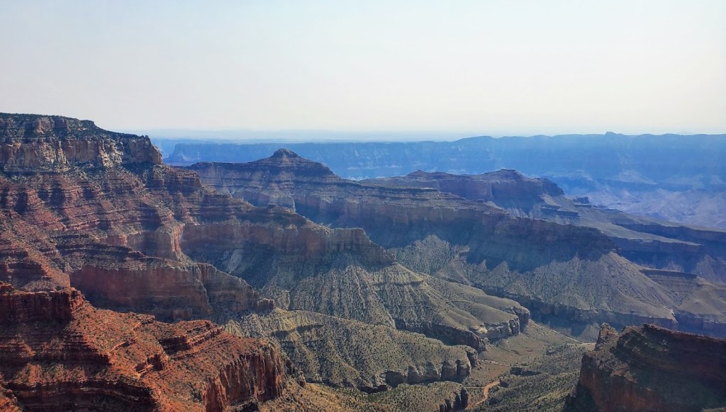
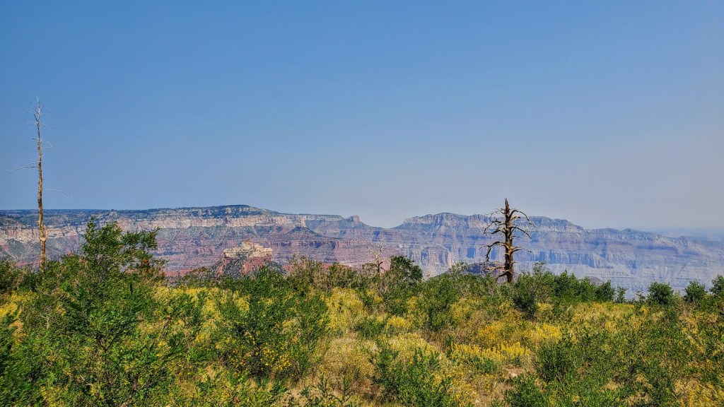
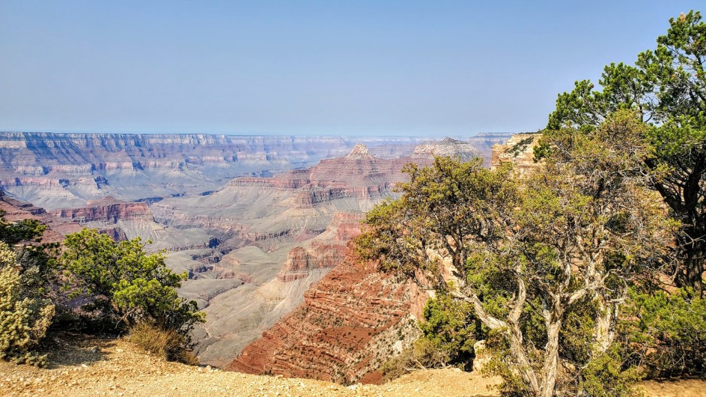
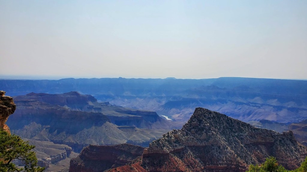
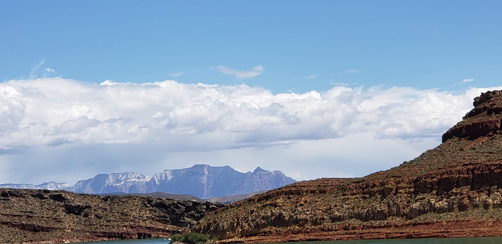
The road sign for Cape Royal says narrow and windy, not recommended for campers so there are no campers on it and very few cars, especially if you get an early start. I defaulted to my gravel bike as I feel a little more secure on it, should I need to suddenly swerve off road. While there isn’t much, if any, of a shoulder most of the time, I felt safe. A road bike would be perfectly fine and a bit faster. Inn my opinon, Cape Royal offers the most dramatic views even though Imperial Point is the highest lookout at 8,800ft. Also, for some reason, the sky was much clearer at Cape Royal. Consider packing some goodies and having your snack at Cape Royal. I was lucky enough to hit it in full wildflower bloom. (My pictures just hint at the incredible views!)
Happy Cycling!
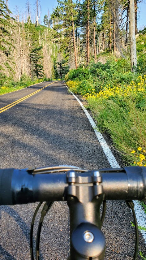
Route: Grand Canyon Lodge to Jacob’s Lake
Mileage: ~41 (1 way)
Elevation gain: ~1,700
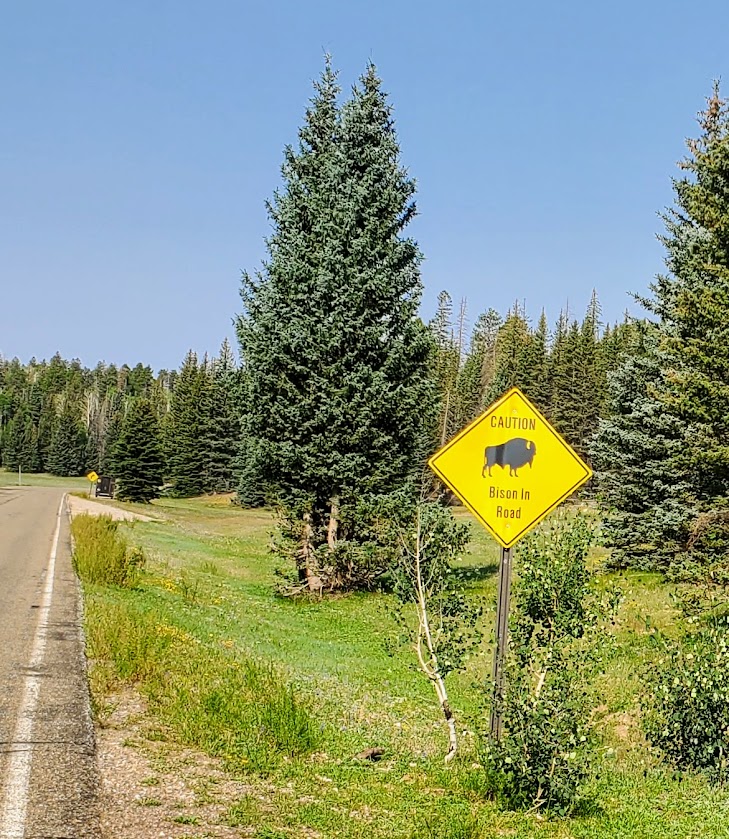
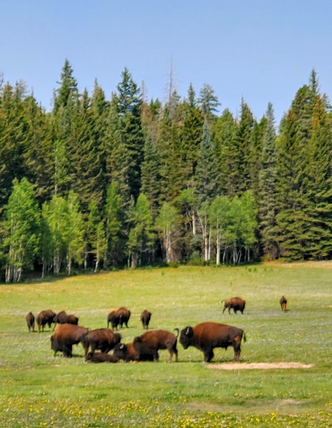
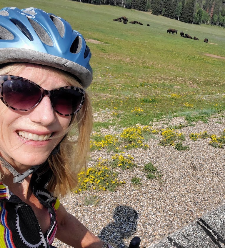
A great second day ride in the North Rim, heading back out the park to Jacob’s Lake. Perhaps you have some noncyclist friends who would opt for picking you up in Jacob’s Lake on the way home, or perhaps you’d like to double your mileage for an out and back? Have lunch in Jacob’s Lake and climb back to the rim? Whatever your pleasure, it will be a pleasure. The scenery is lovely to enjoy from a secure shoulder. Some, but not much car traffic, makes for a serene ride. Bison traffic may be a factor if you’re lucky. Keep a safe distance – they can charge 35 mph, (jump 6ft high), and I’ve heard they have a “thing” for bikers. (Recalling my cross-Catalina ride bison encounter.)
Since the North Rim of the Grand Canyon only receives 10% the visitation of the South Rim, it’s quite peaceful with minimal car traffic. Got to love it!
Elevation gain: ~2,600 ft of climbing (the climb up Snow Canyon alone is 4 miles, 4% grade, and 1,450 ft elevation gain). Clockwise or counter clockwise – either climb Snow Canyon or “The Wall”
Highlights: Gunlock Reservoir, Snow Canyon State Park, Veyo Pie shop, cinder cones, horses, cows, goats, deer, hawks, quail, road runners, and not a single stoplight (though I once had to slow to let some free range cattle cross)
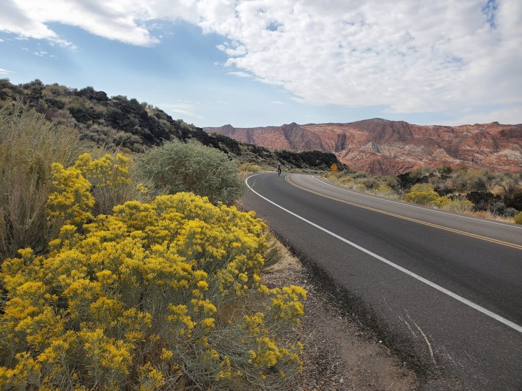
This incredibly scenic, well-marked route has the distinction of being the 1st official designated cycling route in Washington County, UT, it takes you through the towns of Diamond Valley, Dammeron Valley, Veyo, Gunlock, and Ivins. The Vejo Pie Shop is a an opportunity to refuel and indulge in a piece of their famed pies or pastries. The loop is a popular training route for triathletes for the Ironman 70.3 St. George and it was part of the full Ironman St. George course and the recent “Tour de St. George” century ride. I’m so fortunate to have this spectacular ride as my local “go to” ride. If you’re a road biker, this is a must-do if you’re in the area.
Notes: Snow Canyon State Park has an entry fee of $10 for locals/ $15 for out-of-towners; you can also bypass the park and climb or descend the 18 highway instead. There’s a bike path that runs parallel to the 18 northbound; the hills are quite a bit steeper than the highway (knee grinders). For the most part, there’s ample room on the highway, but there are 18-wheelers and trucks with trailers whizzing by so it’s not for the faint of heart…Also, be forewarned there’s a fair amount of debris on the roadsides – glass, steel radial, etc…Be prepared, bring your tough tires and a couple of tubes, Co2s, a hand pump, and plenty of water, especially in the summer. Enjoy the ride!
For those of you who might be wondering, here’s a sample of what biking (road biking and mountain biking) looks like around St. George, Utah. As you can see, the views for much of this 60-mile ride were splendid, quintessential Utah—Virgin River, canyons, red rock, and snow-capped mountains. Road quality varied. (Utah drivers were not quite as courteous as I’d hoped. Lots of trucks sped by us without moving to the left or braking.)
Roadside Red Rock off the 7Virgin River Views From River Rock Roasting CompanyVirgin River Views From River Rock Roasting CompanyRiver Rock Roasting Company: Definitely the Best Coffee / Gastropub and Views Around!
Not bad, eh?
Toquerville /La Verkin Road Bike Loop ~60 Miles, ~2500 feet of climbing
A friend of mine, now a St. George local, guided us on this 60-mile road bike sampler with ~2500 feet of climbing on surrounding highways and byways. We took the lovely, low traffic 7 to Sand Hollow Road (rough surface) by Sand Hollow Reservoir (Half-Ironman site) across to State Street / 9. (The 9 is a main thoroughfare with heavy, fast traffic -not so nice. Maybe save this one for Sunday mornings when most of the locals are at church.)
At the halfway point, we enjoyed some refreshments and superb views at the super scenic, ever popular River Rock Roasting, which is perched on a cliff overlooking Virgin River in La Verkin. If you’re in the area, River Rock Roasting is a must stop and is definitely my top pick for coffee, food, brews and views. It’s slammed on Sundays (apparently everyone who is not in church goes here) so pick a weekday if possible.
Our route back on State Street/9 was topped off with a stop at dazzling Quail Creek State Park and Reservoir. And yes, you can swim in it. No, I didn’t this time, but will next! It’s 120 feet deep in places and stocked with rainbow trout, bullhead catfish, crappie, largemouth bass. There’s boating, kayaking, SUPs, hiking, biking and camping here.
The Veyo Loop is another amazingly scenic route through the Gunlock and Snow Canyon area—one of the top ten routes in Utah -minimal traffic and maximum views!
Desert Canyons Mountain Bike Trails: Pushing Tin and Secret Sauce ~8 miles
Our mountain bike sampler was limited as it had recently rained, but we’ve heard there’s tons of epic trails around here. The driest trail option was the newly developed Desert Canyons Trail System. We cruised around two of the trails, Pushing Tin and Secret Sauce, both pleasant easy to moderate with views from the top of the mesa out to the horizon. Unfortunately, these views are slated to be filled in by a Master Community in the near future. (The developer’s concession / gift was this mountain bike trail system.) We were lucky to have it to ourselves with no building encroachment yet.
Wildflowers and Mesa Top ViewsMetal ArtKara Highlighting Crazy Technical OpportunitiesOpen Views for Now…
Directions: From St. George, take the I-15 S to Desert Canyon s exit and take a left under the overpass
We were told that there’s plenty of great mountain biking in and near St. George, but it wasn’t in the cards for this trip. We did make it to Moab for an epic mountain bike ride – stay tuned for that post.
As far as these 2 rides go, I’ll give them 2 thumbs up.
As a triathlete, I’ve cycled the 30-mile Santa Ana River Trail on multiple occasions. Designated a National Recreation Trail in 1977, it’s the county’s longest cycling and walking trail, running from the Pacific Ocean at Huntington Beach to the Orange/Riverside county line. The vision, now lost, was to create the longest multi-use trail in Southern California with planned extensions to reach as far as Big Bear Lake in San Bernardino County.
Fairly bland for most of the ride, it starts to get pretty near the far end as you pedal along a park in the Anaheim Hills / Yorba Linda area. Here the river opens up to an oasis with green marshes and rolling water frequented by great blue and white herons, geese and other birds. On a clear day the San Gabriel Mountains reveal themselves as the alluring backdrop. If you squint just so, you can block out the concrete that frames the river and the traffic-jammed freeway on the other side. You might even imagine for a moment that you’re in Idaho or some other idyllic place.
Years ago, riding solo I passed a small group of homeless people by a restroom on the trail and remember feeling slightly uneasy. Recently, I heard on NPR that the police had cleaned up the area so I thought I’d give it go since I was going to Orange County for a friend’s 50th birthday party. I guess I should have done my research before I talked my boyfriend into doing the ride with me…
Since the last time I was there, the homeless population has exploded. There was zero evidence of any so called clean up. The area by Anaheim’s Angel Stadium is a wasteland with hundreds of tents and semi-permanent makeshift dwellings strewn on both sides of the bike lane and garbage everywhere. This goes on for a couple miles.
Homelessness is becoming as American as apple pie and baseball in a society where baseball players make millions and cities can’t help those in need or police their confines.
Who are these people? From what I’ve heard the population is a mix of felons, drug addicts and dealers, the mentally ill, veterans, illegal aliens, variations of all of the latter and other misfortunates. And yes, they are mothers, fathers, sisters, brothers and children.
Are they the new Bedouins or gypsies of 21st century? No, they aren’t nomadic or transient. Make no mistake about it; these squatters have set up homesteads here. They have claimed their corner of concrete, creating walls around their “property” with wooden crates , bamboo screening, solar panels and generators. Several camps fly the American flag and have garden chairs placed in front. Others are less hospitable with wooden “Keep Out” signs propped against the tarps that comprise multi-dwelling compounds. Even in homeless America, bigger appears to be better.
I was relieved to see a volunteer group organizing trash collection. As you can imagine, the path is littered with debris of every kind. A church group was there handing out containers of food. There were a couple of car batteries lined up outside tents along the trail – presumably someone charges them too. These services are doubled edged swords, clearly addressing needs while clearly encouraging the permanence of an untenable situation.
Beyond the main encampment strip that runs a couple miles, I saw a tall, older man emerge from a pop-up tent. He was well groomed and completely buttoned up in an oxford shirt and belted jeans, looking like he might be heading to work. He reminded me of my father.
My boyfriend wanted to turn back at the first signs of the squalor. He was concerned that we’d get a flat riding over scattered broken glass and be accosted. Since we’d gone that far, I wanted to hold out for the restorative glimpse of natural beauty at the end…
It’s obvious that the situation is entirely out of control. It’s unsafe and utterly unsanitary. It looks and smells like something from a post-apocalyptic movie, a version of 3rd world lawlessness ―all within walking and biking distance to a couple of Southern California’s wealthiest communities (Newport Beach, Anaheim Hills, Yorba Linda).
The “oasis” was greener than ever; the streaming water sparkling in the sun. The herons, egrets and geese were plentiful. We cycled by two fisherman, surprised when one of them reeled in a good size fish. It was as if we’d been transported to another time and place—an entirely different movie set.
We had 2 near misses on the ride. On the way out, a disheveled woman with 1 front tooth riding an expensive triathlon / time trail bike veered into the path at me from the side lines. Luckily, I was able to swerve and avoid a collision. The ghost of Christmas future or stolen goods? On the way back, I was behind three cyclists when we went under a bridge. In the darkness, a half naked man ran at us yelling something undecipherable. Luckily, the cyclists in front of me managed to maneuver around him. If I’d entered first, I’m not sure what would have happened. Thankfully, disasters averted.
Apparently, the lack of policing and the escalating homeless population are due to jurisdictional disputes between the Anaheim Police Department and the Orange County Sheriff Department. Whatever the case is, it’s absolutely appalling and a shocking reality of life in 21st century America. It’s hard to imagine this colossal problem being addressed effectively anytime soon while it’s easy to imagine it getting worse. This is another skid row in the making – one among many. (Homeless populations are increasing everywhere in California down the coast from Santa Barbara to Laguna Beach and San Diego.)
“Things fall apart; the centre cannot hold;
Mere anarchy is loosed upon the world…”
W. B. Yeats
For the record, I’m not unsympathetic to the plight of my fellow man and understand that a series of unfortunate events and / or choices can have a cataclysmic impact. We also know that the human spirit can overcome and rise above most events with and without help. Regardless of your perspective, it’s a complicated tragedy. Some might say it’s just one of the many signs of Western Civilization’s decline.
Too melodramatic? Perhaps. What I know is what I’d hoped would be a stress-free bike ride on the Santa Ana River Trail was anything but. I’ve been waiting for my epiphany from this experience – yes, gratitude for my privileged life and what else?
A deeper conviction that I need to live closer to nature somewhere beautiful and under-populated, far away from Southern California. Am I running away? Yes, as fast and as far away as I can. I know, places like Idaho and Montana have their problems too, but I can face them better when I’m breathing fresh air and am surrounded by pristine wilderness.
I thought if it were me, my tent would be under the trees at the oasis overlooking the marsh – far from everyone else. I’d be fine walking a couple miles to partake in the free food and trash services. I would not be flying the American flag.
Do you have a large homeless population where you live? What are your thoughts?
My camera battery died so I couldn’t take more pictures, which is probably just as well as it’s not a place you want to be loitering. It is something you have to see to believe. Below are a couple recent articles in the OC Register with pictures and stories that better capture the extent of the problem.
Better yet, here are 2 videos by fellow cyclists – not sure about the happy music soundtrack in the one or the snarky commentary in the other, but they provide a live picture: