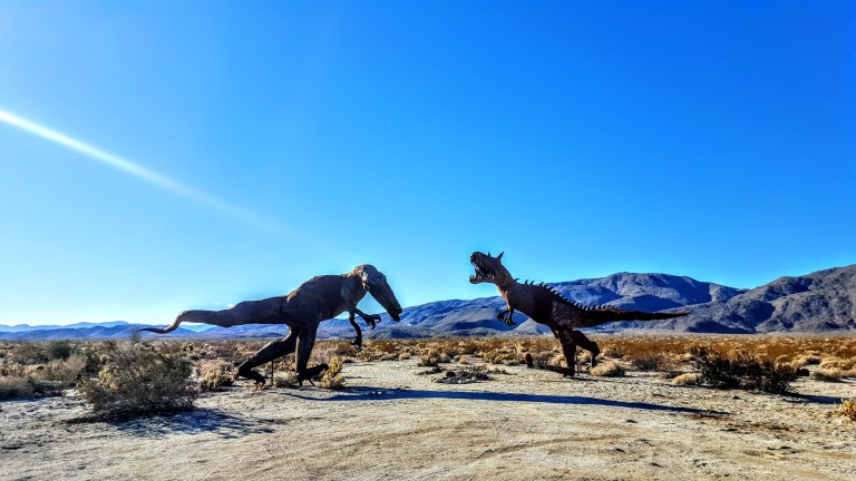
Thanks to the owner of Galleta Meadows Estate, Dennis Avery, there’s an incredible al fresco metal art sculpture exhibition to be discovered in Anza Borrego. Over 130 metal sculptures created by artist/welder Ricardo Breceda seem to appear out of nowhere in the barren, dramatic landscape. With a little imagination, you’re transported to the prehistoric times of dinosaurs, mastodons and saber-tooth tigers.
The exhibition spans about 10 square miles. Many of the sculptures can be seen from the road; others require some driving, hiking or mountain biking in on sandy roads. Some are in clusters, others quite spread out. You never now what kind of creature you’ll encounter next. Highlights include a giant scorpion, a 350 foot-long sea dragon and so many more. I’ll leave you to discover the rest yourself. My favorites, as you can tell, were the prehistoric sculptures.
It’s definitely worth seeing and no doubt a blast for the kids.
Getting there: Take the S22 into Anza Borrego and cruise the valley looking at both sides of the road. (If you want a guided map for the sculptures, you can pick one up at the visitor center in town.)
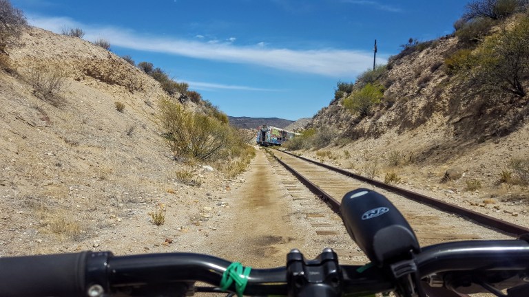
Deep in the heart of the Jacumba Mountains overlooking Carrizo Gorge in Anza Borrego State Park, you’ll find the Goat Canyon Trestle. Getting to the world’s largest curved wooden trestle is like being transported to the wild west of days done by. You’ll traverse dark tunnels in various stages of collapse, dodge rock slides, narrowly avoid precipitous drops into rock canyons, explore abandoned trains and endure the blazing desert sun. If this is your idea of fun, read on. Ok, it’s not that bad. In fact, it’s an easy, flat mtb cruise or a longish flat hike through some very cool (pun intended) desert terrain.
(Video credit and pics I’m in below: Ken Wells)
It’s slow going as there are several points where you have to lift your bike over one obstacle or another. You can’t speed through because you never know what’s around the next corner or if the bottom might drop out in front of you.
Be alert and cautious all the way out and back. Headlamps are a must for the tunnels, lots of obstacles in there. Workout-wise, it’s easy – safety-wise, it could be considered a bit sketchy.
As you bike along the railway, sometimes the path is quite narrow with a precipitous drop into the rocky canyon below. A moment of distraction could make for a very bad day. Wouldn’t suggest mountain biking for kids here, unless they are quite skilled and cautious riders.
Up close, the trestle seems a bit rickety, like a skinny, dilapidated Jenga set.
This slideshow requires JavaScript.
Background: The trestle was built in 1933, as part of the San Diego and Arizona Eastern Railway, aka “the impossible railroad” that ran through Baja California and Eastern San Diego County and ended in Imperial Valley. Over the years, collapsed tunnels and rock slides plagued the railroad, including the collapse of Tunnel 15, which led to the creation of the trestle. The trestle was constructed of wood (no nails used), rather than metal due to the area’s extreme temperature fluctuations, which can lead to “metal fatigue” / failure and it was designed with a 14 degree angle to offset Goat Canyon’s high winds. By 2008, rail traffic had ceased. As recently as last year, another tunnel, Number 6, near the trestle collapsed…(Yikes.)
Distance: Roundtrip 10 -14 miles, depending on where you start
Getting there: 8E from San Diego, take the Jacumba Exit
Parking: Park for free in the dirt lot right off the freeway at the Jacumba exit and follow the dirt portion of Carrizo Gorge Road 2 miles towards the DeAnza Spring Resort, the largest “clothing optional” resort in North America. Optionally, pay $5 to park at the resort. 1951 Carrizo Gorge Rd. There’s a Subway & gas station right off the freeway. You can also grab a bite & beer at the resort after your ride…
Note: This is the desert, plan accordingly – ample water, sunscreen, hat, etc…
Cowles Mountain (1,593-foot summit) is the highest point in the city of San Diego. It’s part of Mission Trails Regional Park, a 5,800-acre open space preserve that is the 7th-largest open space urban park in the United States. It contains sixty miles of hiking, mountain bike and equestrian trails.
To call Cowles a mountain is to be very liberal with the word. I should note that the park has a 5 “peak” challenge if your hiking peeps want a minor challenge and want to document your feats – here’s the scoop. Cowles is the highest peak. This might be fun for kids, but apparently lots of adults do it for bragging rights too. I will say that on a clear day, the stunning views span 360 degrees from Lake Murray, downtown San Diego, Point Loma, La Jolla, and Mexico and out across the glimmering Pacific to the San Carlos Islands. See feature picture above. (Unfortunately, I dropped my camera on a rock so I have limited pics.)
Distance: 2.9 miles up & back
It’s a very popular trail so expect lots of humans and their canines…There are a couple of different ways to reach the top from various starting points and parking lots. The hike itself is moderate (with some steeper sections that will get those calves & glutes burning). It’s decent workout, especially if you run it. There are single track trails and some fire road. It’s short from any direction so I explored up and down on a couple of trails and was a little disappointed that there wasn’t more to see. You can’t really get lost so do as much or as little as you like.
Getting there:
The main trailhead is in the San Carlos neighborhood on the corner of Golfcrest Drive and Navajo Road
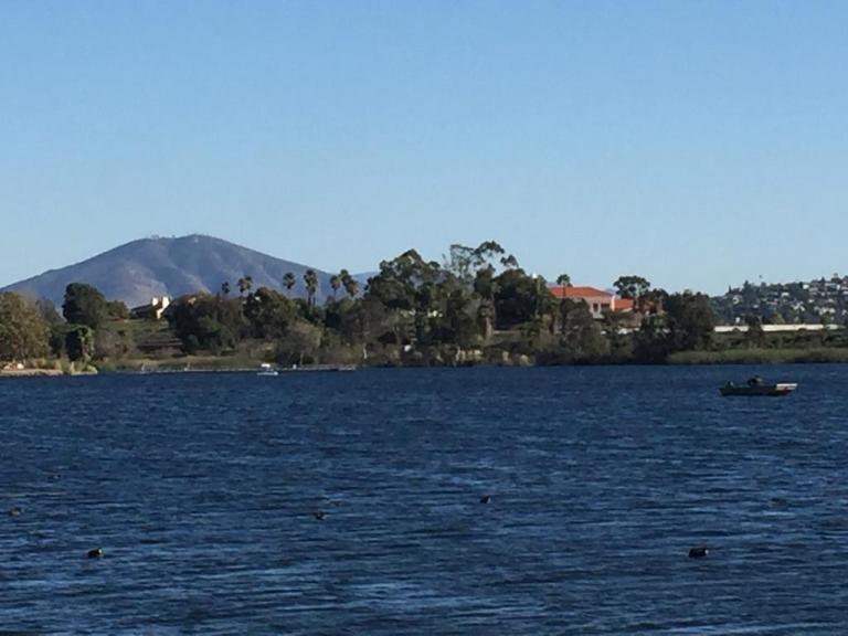
Lovely Lake Murray
Since I didn’t quite get enough enough of a workout / nature fix, I decided to check out alluring Lake Murray Reservoir, also part of the Mission Trails Regional Park. I strolled the paved road that navigates around most of the lake stopping short of the dam (no access). It’s another popular spot – walkers, runners, bladders, and even road bikers aplenty (the latter seems silly to me, because the path / road is only 3.2 mi long and there are many children and dogs on it).
Lake Murray is a great spot for birdwatchers with abundant ducks, geese, and herons abound and about 149 bird species to observe. It’s a pleasant spot for a picnic too.
Go Fish
Lake Murray is open for shore fishing and private boats, kayaks, and float tubes seven days a week from 5:30 a.m. to 8:00 p.m. Permits can be purchased onsite at the iron ranger boxes. The lake is stocked with Florida-strain largemouth bass, bluegill, channel catfish, black crappie, and trout. Minimum size limit for bass is 12 inches.
Fish limits: 5 trout, 5 bass (min. 12 inches), 5 catfish, 25 crappie and bluegill total, no other species limits
Monserate Mountain is more of a steepish molehill than a mountain. You can hike, bike or run up the trail for a short, steep, incline workout and the reward of expansive views of the mountains (Agua Tibia, Red Mountain, Santa Ana Mountains), farmland in the valley below, and a sliver of Pacific Ocean way out to the west. I have mixed feeling about this one for reasons detailed below…
History
Monserate Mountain was part of an 13,323-acre Rancho Monserate Mexican Land Grant from 1853 that originally extended south and east of the present day Fallbrook down to the San Luis Rey River.
Pros
If you’re in or near the area, you can get a quick workout here with sweet 360 degree views at the top. Also, I think that it might be the right balance of tough and short for hardy hiker kids who get a feeling of accomplishment from doing something challenging.
There are a couple offshoot trails on the way up: Canoninta Trail and Red Diamond. I didn’t take those, but once at the top, headed south along a Ridge Trail to the water tank. This was the best part of the hike for me – it faced away from the freeway on a little stretch of single track with views into the valleys below and east across the mountain ridges. The Ridge Trail descends gradually with the help of a short wooden staircase and then drops you out on a paved road. (In the pic below, I turned around and ran up the staircase for the pure joy of a little more incline.)
Glutton for the incline.Mountains to the east from the Ridge Trail.
Cons
The barren, dirt trail going up has little to no aesthetic appeal. This trail gets lots of traffic, human and dog (too much I’d say). And I’m afraid it smells like it too. (I have a sensitive schnozz and the trail smelt like dog poop most of the way up.) Also read a review that someone got bitten by a dog twice on this trail. The roar of the 15 freeway below is also a bit off putting as are the weekend crowds that you have to hike around. (I was so uninspired and turned off by the dog poop smell, I didn’t take any pictures on the way up.) Yes, that bad – but then again, I’m a hiking snob. You’ll see why if you visit some of my other posts.
If you’re in the area, do it. Otherwise, I wouldn’t go too far out of your way for this one. Distance: 3.2 miles up and back without add ons, or 4.4 mile loop adding on the Ridge Trail loop to the water tank. Elevation gain /loss: ~1150 feet, moderately strenuous, depending on what shape you’re in. If you’re a trail runner, you’ll like it and you’ll want to add on the Ridge Trail water tank loop. Terrain: Mostly wide dirt path with rocks and some erosion, some single track, paved road & fire road if you do the 4.4 mile loop.
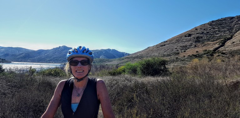
My back was a little tweaked from last week’s roller blade when I used my butt as a brake so I was looking for something mellow to do this weekend. That’s when I thought of mt.biking around Lake Hodges on the flat section of the San Dieguito River Park Coast to Crest Trail. This multi-use trail is open to hikers/runners, mountain bikers and equestrians. The main trail (a planned 70 miles – 45 miles of which currently exists ) extends from Del Mar to Volcan mountain in Julian. And there are over 20 miles of auxiliary trails within the River Park to play on.
I chose an easy cruise on a friendly wide dirt trail through the North side of the park. If you add on some single track on the flip side, you can make it around to the dam.)
(Option to stop in for some refreshments at Herandez Hidaway on Lake Drive.) We passed it up because my back was acting up (could have been the three falls). There are only about 3 spots where a mtb novice or clutz like me needs to walk (should have walked) hence the falls. Otherwise, super pleasant, beginner mtb trail. Managed to get about 16 miles in on the out and back.
Lake Hodges Dam in the DistanceSan Dieguito River Park Lake Hodges Bike & Pedestrian Bridge with Bernardo Mountain to the left.
I’ve ridden and run the South side too – not as much mileage there and much better views on the North side, in my opinion. If you’re tough and technical, you can go for the Bernardo Mountain Summit trail – looks fun. You can also find more trails under the pedestrian bridge, but you may encounter some challenging single track there. (I might hike a couple of these to scout them first and report back. I suspect they won’t be as scenic since they ride away from the lake.)
Other options to explore if you’re not afraid of some rugged single track
Getting there:
There are a number of ways to access the trails. The pedestrian / bike bridge is a good a starting point for explorations North or South.
I-15 freeway to West Bernardo/Pomerado Road, go west and park in the Bernardo Bay parking lot on the right just before Rancho Bernardo Community Park,
Or perhaps consider parking your car at Hernadez Hideaway on the other side of the lake so you can look forward to lunch and libations after your ride.
Hernadez Hideaway, 19320 Lake Drive Escondido, California 92029