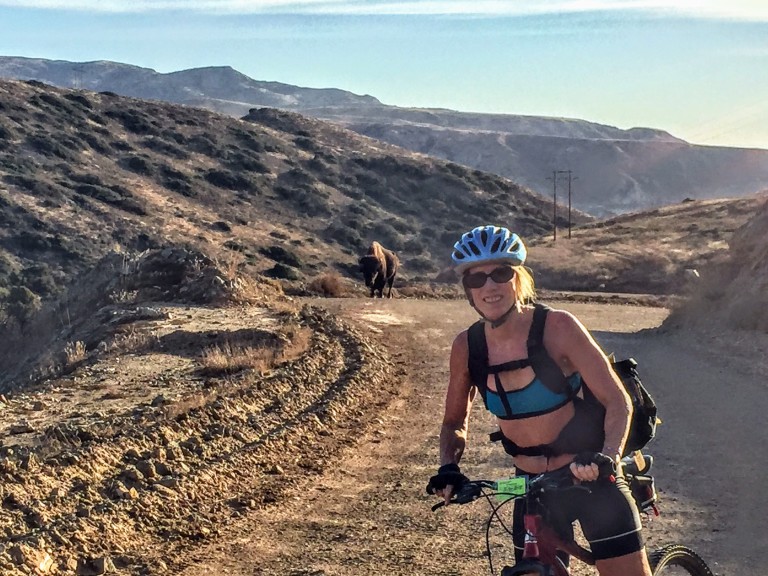
My back was a little tweaked from last week’s roller blade when I used my butt as a brake so I was looking for something mellow to do this weekend. That’s when I thought of mt.biking around Lake Hodges on the flat section of the San Dieguito River Park Coast to Crest Trail. This multi-use trail is open to hikers/runners, mountain bikers and equestrians. The main trail (a planned 70 miles – 45 miles of which currently exists ) extends from Del Mar to Volcan mountain in Julian. And there are over 20 miles of auxiliary trails within the River Park to play on.
I chose an easy cruise on a friendly wide dirt trail through the North side of the park. If you add on some single track on the flip side, you can make it around to the dam.)
(Option to stop in for some refreshments at Herandez Hidaway on Lake Drive.) We passed it up because my back was acting up (could have been the three falls). There are only about 3 spots where a mtb novice or clutz like me needs to walk (should have walked) hence the falls. Otherwise, super pleasant, beginner mtb trail. Managed to get about 16 miles in on the out and back.
Lake Hodges Dam in the DistanceSan Dieguito River Park Lake Hodges Bike & Pedestrian Bridge with Bernardo Mountain to the left.
I’ve ridden and run the South side too – not as much mileage there and much better views on the North side, in my opinion. If you’re tough and technical, you can go for the Bernardo Mountain Summit trail – looks fun. You can also find more trails under the pedestrian bridge, but you may encounter some challenging single track there. (I might hike a couple of these to scout them first and report back. I suspect they won’t be as scenic since they ride away from the lake.)
Other options to explore if you’re not afraid of some rugged single track
Getting there:
There are a number of ways to access the trails. The pedestrian / bike bridge is a good a starting point for explorations North or South.
I-15 freeway to West Bernardo/Pomerado Road, go west and park in the Bernardo Bay parking lot on the right just before Rancho Bernardo Community Park,
Or perhaps consider parking your car at Hernadez Hideaway on the other side of the lake so you can look forward to lunch and libations after your ride.
Hernadez Hideaway, 19320 Lake Drive Escondido, California 92029
A few people have asked me what I’d recommend for a couples’ 2 to 3 night camping trip in Catalina. For nature lover’s with limited time, I suggest you skip touristy (though charming) Avalon and head straight for Catalina’s “Wildland” gems. Most Catalina aficionados concur that the 2 most beautiful spots on the island (not that you can really go wrong anywhere) are Little Harbor Campground and Parson’s Landing Campground. I’ll focus this post on them.
If you like this sort of thing, you’ll love those 2 spots.
Contemplating the climb ahead from Little Harbor Cove
Leaving Lovely Little Harbor
Heading down to picturesque Parson’s Landing
MAP
How you plan your getaway comes down to your preferred balance of activity to relaxation.
If you want to see both Little Harbor and Parson’s Landing, the easiest way to do it is to take the San Pedro ferry direct to Two Harbors. Once there, you are equidistant to Parson’s Landing and Little Harbor – this gives you the most flexibility and the most relaxation and recreation options. You can grab a bite and set out for either destination as a day hike / bike or an overnight at one or both of them. You can also catch a shuttle one or both ways.
When you visit Two Harbors, enjoy a meal at Doug’s Harbor Sands – the only restaurant / bar in town. I recommend the Mahe and a Buffalo Milk or two for dessert. Buffalo Milk is a delicious libation named after the island’s iconic buffalo (think alcoholic chocolate milkshake). I’d post a picture of one, but I drank them so fast I forgot to take one.
Otherwise, you could stay over in Little Harbor night 1 and then work your way West to Two Harbors and Parson’s Landing. On a quickie? Perhaps you take the Safari Bus back to Two Harbors or Avalon. (Arrange in advance.)
Staying Overnight in Two Harbors
Two Harbors Campground (42 tent sites & 3 Group sites) about a 1/4 from “town” on a bluff overlooking the Pacific. Outdoor cold water showers & portapotties.
In “town”, the Camping Cabins offer simple comforts on a budget ($50-70 a night) They are available November through March only.
Note: There are coin operated hot water showers in Two Harbors.
After roughing it for a day or two, I always like to throw in a little luxury. See why the rustic Banning House Lodge in Two Harbors is myTop Pick .
Two Harbors Things to Do: Diving, snorkeling, swimming, stand-up-paddling, kayaking, fishing, exploring and relaxing. So yes, you can have tons of fun just hanging in gorgeous Two Harbors. Did I mention the Buffalo Milk? (Yeah, I did.)
Head from Two Harbors to Parson’s Landing (via West End Road – easy fire road ~7 miles & or the Trans Catalina Trail – hard single track ~11 miles) and camp out there. Note there is no running water at this campsite. You can hike from here to Starlight Beach (the Western most point of the island), but be prepared for 20 miles round trip as Starlight Beach is day use only.
Avalon to Two Harbors ~23 miles (MTB route – ~3,284 elevation gain)
Little Harbor to Two Harbors ~7 miles by fire road or shorter by single track, expect a fair amount of climbing in either direction
Two Harbors to Parson’s Landing ~7 easy miles West End Road or ~11 via a challenging portion of the Trans Catalina Trail (hikers only) Note: Parson’s Landing Campgraound has no running water.
Two Harbors to Starlight Beach ~17 to ~21 miles depending on your route (see above)
Catch the Catalina Express from San Pedro to go direct to Two Harbors ~$75 ea round trip.
Or treat yourself to a Helicopter ride, starting at ~$135 one way depending upon your departure point. It’s a quick way to spend $135, but it is a dazzling ~15+ minutes. (One way is enough, unless you’re in a hurry and have $ to burn.)
If you have a boat, you’ve got it made to explore your way.
If you start in Avalon, you can take the island’s Safari Bus to Little Harbor, Two Harbors, or Parson’s Landing, but you are limited by their schedule. Mountain biking or hiking is possible too, but only if you’re up for ~23 somewhat tortuous miles (especially if you’re going to be carrying a pack) see my Catalina mtb. adventure post 1 & 3). There is a new Catalina Back Country Concierge that offers gear haul and other services, but they may not be open on weekdays in the off season – – at least they weren’t when we called them.
Another option is to stay in Little Harbor the first night and save the final 7 miles to Two Harbors for Day 2…
So many fantastic options, so little time. Be safe and have a blast!
I’ve been all over the island, the terrain can be challenging and most of it is completely exposed. (Carry plenty of water and sunscreen.) Keep ~150 yards from Buffalo. (They don’t like bikers.) Stay on designated trails and fire roads. Taking that short cut through brush may be tempting, but my brother will tell you, it’s not worth it. He got bitten by a rattlesnake there doing just that and had to be airlifted off the island. He’s fine now, but it was a bit sketchy during his two weeks in ICU…And no, I wasn’t on that trip.
Let me know if you have questions and do tell me what you did on your Catalina getaway!
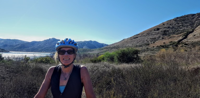
So I asked my athletic beau, Ken, “How about we take our mountain bikes to Catalina and ride from Avalon to Two Harbors, hang out and ride around there for a day, and then ride back? What do you think? ”
“Sure, sounds good,” he replied without blinking an eye…This is where I should have pulled out the disclaimers about the ~1700 foot climbs (that’s plural) that we’d be doing from sea level over the course of ~21 mile traverse across steep, unforgiving fire roads, and the fact that he’d be carrying a heavier pack than I…
I did dig out my old map of the marathon route with its epic elevation gains and losses, but he didn’t give it a glance. I declared with my usual exuberance, “It’s going to be a tough one, but it will be a great adventure!” You see, back in 2000, (yes, nearly two decades ago), I ran the Catalina Marathon, which takes you across some of the same routes so I had a distant, but visceral memory of how “challenging” the climbs on the island can be. (Decades of trail running has also taught me that’s it far easier to run up hills than it is to bike up them, especially if you are on heavy, beater bikes lugging packs on your back.) Of course, I’m nearly 2 decades older now and should also mention that we don’t mountain bike much (our last MTB adventure was Noble Canyon and we all know how that went. My bruises have finally faded,)
Bottom line, we both try to maintain a moderately-high fitness level for our weekend warrior and extended escapades and active adventures…(I’ve been focusing on yoga, swimming, hiking and a weekly road bike and he’s been running, and joining me for swims and road bikes as his schedule allows.) Unfortunately, I can’t run any more due to literally running out of cartilage in both my knees. Ugh, I know! For some reason, I thought I would be ok on the mountain bike with the hills…
About Catalina
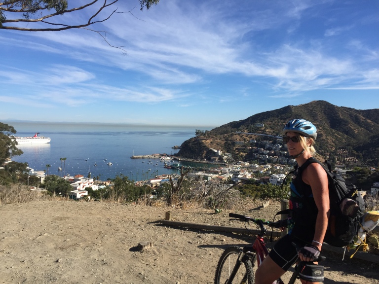
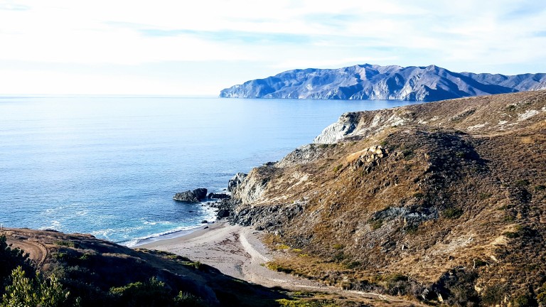
Catalina Island is a small (22 miles long & 8 miles at its widest point) rocky gem in the Pacific ~ 22 miles from Los Angeles, but thanks to nearly 50 years of the Catalina Islands Conservancy’s good work, it’s really worlds away! The island’s topography is a study in rugged beauty with steep cliffs and jagged coastline. Ninety percent of the island’s 4k population live in Avalon, which is also the Island’s major tourist destination with quaint shops, restaurants and bars. Yes, it has its charm, but you know by now that I’m more of a “wildlands” fan myself. That’s why we’re heading to the remote Westside of the island and staying in Two Harbors,
View point just after the initial climb out of Avalon on Stage Road – that’s the “What did I get us into this time?” look. Notice the over-packed backpack.
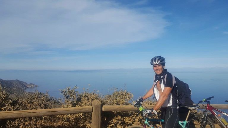
So I was wrong about that. Not long after the picture above was taken, 3/4 through the first climb from sea level up the airport road, I thought my knees were going to explode. No way I can make this, I thought. That’s when Ken pulled over and ordered me to empty everything heavy out of my pack and put it into his. I didn’t argue, toughing it out wasn’t an option if we were going to make it across. Yes, Ken is a stud and my hero! Wouldn’t have been able to make it without him taking on the extra poundage.
My hero, Ken, aka Superman, all smiles despite the extra weight in his pack. This is at the top of the first climb, he’s thinking the worst is over…I know we’ve only just begun.But views like these of the remote backside of Catalina can turn even my worst grimace into a smile…
We left Avalon after 1PM and we didn’t pass the halfway mark until 3PM with all my knee breaks so we were getting a little worried that we might not make it by dark. There were no hikers or bikers out except for us and only a few cars and Island Conservancy trucks passed us. We had decided not to camp as we’d be carrying the weight of sleeping bags and Thermarests and possibly a tent too. Instead, we decided to treat ourselves to a stay at the Banning House Lodge for both our recent birthdays. So instead of stopping and relaxing at one of these gorgeous deserted beaches we pushed on and on…
We came around a corner and a gorgeous Catalina Fox crossed in front of Ken. Unfortunately, my camera was in my backpack and getting it out would have scared it away so we both just sat still and watched in quiet wonder as the beautiful creature took 5 steps looked back at us, took five more, looked back again, and once more before disappearing into the roadside brush. As if to say, “Hey, I’m giving you guys plenty of photo ops, what’s your problem?” This would be the first of several fox sightings in which I would be camera cursed each time. (Luckily, we met a great couple from Carlsbad (John & Julie) who caught some great pics while we were having dinner together at Harbor Sands. Stay tuned.)
We would have one more notably larger critter encounter on our final climb out of Little Harbor, a brute of a buffalo was snorting and drooling his way up the hill. He was on the far right. We stayed as far left as we could.
Buffalo can charge at 35 mph and jump 6 feet high. And, we were told later, not unlike other aggressors, they have a thing for bikers. Yes, yikes. That’s my “Forget the picture and let’s keep moving.” look.
About Catalina’s Wild Buffalo
In 1924, 14 buffalo were brought to the island for a movie shoot and the rest, they say, is history. The bison thrived here and at one point the herd grew to 600. Today, the Catalina Island Conservancy manages the population (via birth control) to about 150, thereby striking the balance between protecting the sensitive ecosystem and keeping the herd healthy.
The weather was perfect and the visibility out to the mainland was the best I’ve ever seen it. Unfortunately, camera didn’t quite capture it. (Wasn’t going to bring my heavy Nikon.)
We made it just in time for sunset and the splendid wine and cheese welcome at the charming Banning House Lodge (another 150 ft climb) just to add insult to injury.
Big sigh of relief after our full, half-day adventure – brutal workout, spectacular views, a studly boyfriend who’s a great sport, a hot shower and a comfy bed – now that’s a birthday to remember. Stay tuned for Part II & III. (If you’re a mountain bike legend fan, you’re never going to believe who we ran into in the middle of the island on our way back to Avalon…)
Was gunho to get away to somewhere new this weekend. Perhaps a little too gunho…Wasn’t quite as thorough with the research as I usually am, but had done enough to know that the Laguna Mountain Recreation Area is a great spot for mountain biking and enjoying great scenery as you traverse 3 ecosystems: mixed-conifer/black oak forest, alpine meadows and desert.
And it certainly served up some heavenly single track around Laguna Meadow and beyond.
I’d call it Bait & Switch Trail
Still blissful in the meadows
Sublime, right? And so it went for about 6 miles before things took a gnarly turn for the worse. Scattered rocks, became bulky blocks with jagged edges, boulders and ankle bashing bruisers galore. I didn’t get pictures of these tortuous areas because, I was too miserable fending off hordes of face flies while hike-a-biking my hefty 35 pound bike. Even if I’d had a Go Pro, you wouldn’t have been able to see beyond the blur of flies – that’s how bad it was. Brutal – yes.
We only saw 2 other mountain bikers on the rough lower portion. They were wearing completely padded body armor suits with full face helmets. Another clue that I was way out of my element…I’m tough, but I’m not technical and have horrible eyesight and depth perception so this it was more than a bit hazardous. I’m extremely lucky to have escaped with only a handful of bruises and scratches.
( I later discovered – post-research – that this area is notorious among mt.bikers and is affectionately called Stairway to Hell and Roman Road.)
Here are a couple links to youtube videos on the area.
We kept looking for a route that would loop us back as a couple people at the trail head had mentioned, but we never found it. And there was no way we were going back up the Stairway to Hell…I even thought of abandoning my beater mt. bike and hiking out even though I only had my bikes shoes.
A smile (or grimace) of relief after surviving Stairway to Hell
Instead, we made it out to the Pine Valley picnic area and then out the road. Realizing then that we would have to ride up the mountain via Sunrise Highway. Not much of a shoulder there, but a lesser evil than Stairway to Hell. Climbing 8 miles and 3K feet back to the car after the tortuous Noble Canyon was its own purgatory, and certainly, I’ve learned my lesson about doing my research. Perhaps next time, my BF will read the links I send him prior to departure too. (Snarkyness aside – selfreliance is critical even when you’re with a partner. If we both had read the trail reports thoroughly, one of us likely would have retained which trail to loop back on – though we still might not have found it…)
This day certainly put us to the test. Even though we both keep a fairly high fitness level – it kicked our butts. And to both our credits, we didn’t bite each others heads off. I did come close to meltdown with the face flies on attack while I was hefting my bike over boulder after boulder, but I held it together. We both did, taking the punishment mostly in silent, focused suffering. What was going to be a pleasant morning adventure, ended up being a whole day ordeal. Great workout – not so fun.
I’ve reread some of the trail reports and it sounds like there are other options if you want to avoid the burly section of Noble Canyon. I may be back, but need a cooling off period and time for my bruises to heal first.
Where: 40 minutes from downtown San Diego, near Pine Valley, off of Pine Creek Road North of I8 or off of Sunrise Highway to go top to bottom
What: Noble Canyon Trail, Laguna Mountain Recreation Area
Distance: 19.9 Miles out & back
Elevation gain/loss: 3,346
Rating: For hiking: Moderate. For Mt. biking: Advanced+++
Notes: Adventure Pass required.
Tip: Bring bug spray and plenty of water. Consider a car shuttle for a 10 mile option. Given that it’s single track and a mountain biker destination, it’s not the most peaceful option for hikers…The trail head maps aren’t great, do your research first. ; )
Have you had any small adventures turn into challenging ordeals? Do tell.
Trailhead: 13852-, 13998 Jamul Drive, Jamul, CA 91935
~25 miles from downtown San Diego.Take 94 East, exit at Campo Road. Follow Campo Road for ~ 4.5 miles, turn left onto Lyons Valley Road and then left on Jamul Drive and you’ll see the dirt turnout / parking lot at 0.4 mile.Trail starts at the kiosk.
Main trail
~5 mile out & back
1,400 feet gain & loss
Moderate to strenuous depending on your fitness level
Dog and mountain bike friendly
My take
Drove down from North County for this one and so happy I did. Had low expectations as I’d never heard of this trail, but was pleasantly surprised. What a sweet little gem. This area is part of the San Diego National Wildlife Refuge. Not as well known as many of the popular SD area hikes nearby Mount Woodson, Iron Mountain, and Cowles Mountain, but definitely a contender for it’s beauty and views.
It’s a great hike with mostly friendly terrain, except for the steepest area not far from the top, which was a bit of a rock field. (If you have tender feet, you might be happier in hiking shoes versus running shoes.) Don’t worry, the steepest area is fairly short so you won’t suffer long.) Mountain bikes are allowed, but I didn’t see any and there were only a few hikers sharing the trail. It’s a good spot for a trail run too. It’s a relatively quick hike and a lovely way to spend a morning or afternoon.
Highlights
Late season wildflowers and wonderful views of San Miguel Mountain and Tecate peak to the East, Mount Helix , Cowles Mountain, El Cajon Mountain, and even Cuyamaca in the distance – apparently on some days you can see all the way to Coronado, Point Loma and the expanse of Pacific. And hiking uphill is always more rewarding —better views and better workout!
This slideshow requires JavaScript.
Rock scramble at the top – optional.
Caution
There are no trail signs so stay on the most obvious (widest & well traveled) route. (You can take a couple viewpoint detours, but return to the main trail.) Be on guard for rattle snakes and ticks and bring water. The trail is exposed the entire way so you’ll want to avoid hiking in the heat of the day.