Avalon to Two Harbors: Catalina MTB Adventure, Part 1

So I asked my athletic beau, Ken, “How about we take our mountain bikes to Catalina and ride from Avalon to Two Harbors, hang out and ride around there for a day, and then ride back? What do you think? ”

“Sure, sounds good,” he replied without blinking an eye…This is where I should have pulled out the disclaimers about the ~1700 foot climbs (that’s plural) that we’d be doing from sea level over the course of ~21 mile traverse across steep, unforgiving fire roads, and the fact that he’d be carrying a heavier pack than I…

I did dig out my old map of the marathon route with its epic elevation gains and losses, but he didn’t give it a glance. I declared with my usual exuberance, “It’s going to be a tough one, but it will be a great adventure!” You see, back in 2000, (yes, nearly two decades ago), I ran the Catalina Marathon, which takes you across some of the same routes so I had a distant, but visceral memory of how “challenging” the climbs on the island can be.  (Decades of trail running has also taught me that’s it far easier to run up hills than it is to bike up them, especially if you are on heavy, beater bikes lugging packs on your back.) Of course, I’m nearly 2 decades older now and should also mention that we don’t mountain bike much (our last MTB adventure was Noble Canyon and we all know how that went. My bruises have finally faded,)

Bottom line, we both try to maintain a moderately-high fitness level for our weekend warrior and extended escapades and active adventures…(I’ve been focusing on yoga, swimming, hiking and a weekly road bike and he’s been running, and joining me for swims and road bikes as his schedule allows.) Unfortunately, I can’t run any more due to literally running out of cartilage in both my knees. Ugh, I know! For some reason, I thought I would be ok on the mountain bike with the hills…

About Catalina

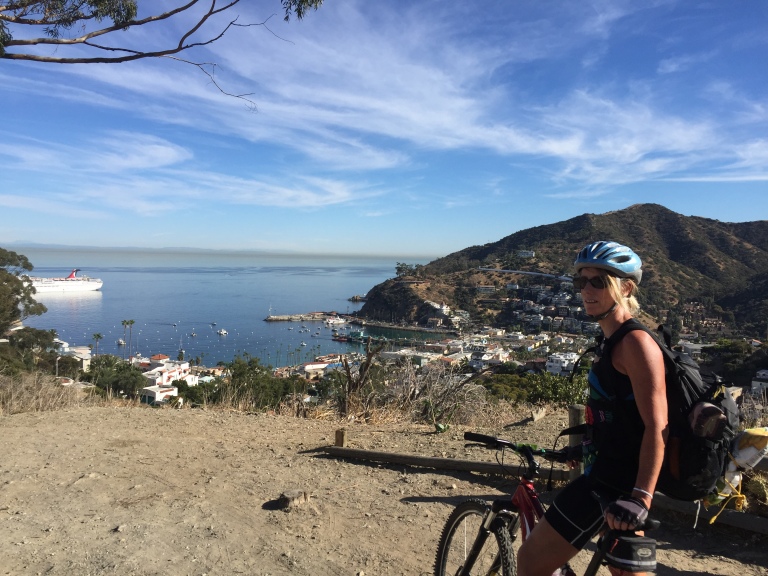
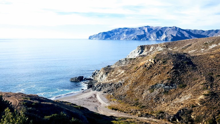
Catalina Island is a small (22 miles long & 8 miles at its widest point) rocky gem in the Pacific ~ 22 miles from Los Angeles, but thanks to nearly 50 years of the Catalina Islands Conservancy’s good work, it’s really worlds away! The island’s topography is a study in rugged beauty with steep cliffs and jagged coastline. Ninety percent of the island’s 4k population live in Avalon, which is also the Island’s major tourist destination with quaint shops, restaurants and bars. Yes, it has its charm, but you know by now that I’m more of a “wildlands” fan myself. That’s why we’re heading to the remote Westside of the island and staying in Two Harbors,

IMG_2190
View point just after the initial climb out of Avalon on Stage Road – that’s the “What did I get us into this time?” look. Notice the over-packed backpack.

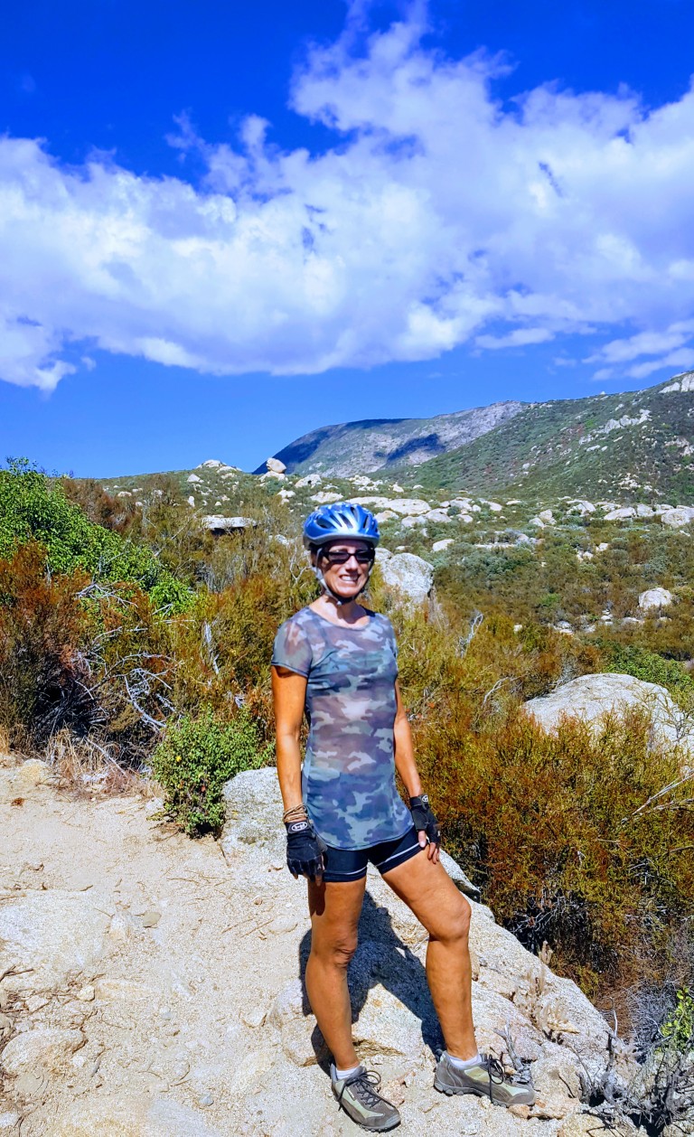
So I was wrong about that. Not long after the picture above was taken, 3/4 through the first climb from sea level up the airport road, I thought my knees were going to explode. No way I can make this, I thought. That’s when Ken pulled over and ordered me to empty everything heavy out of my pack and put it into his. I didn’t argue, toughing it out wasn’t an option if we were going to make it across. Yes, Ken is a stud and my hero! Wouldn’t have been able to make it without him taking on the extra poundage.


20171211_133852.jpg
My hero, Ken, aka Superman, all smiles despite the extra weight in his pack. This is at the top of the first climb, he’s thinking the worst is over…I know we’ve only just begun.
20171211_150342.jpg
But views like these of the remote backside of Catalina can turn even my worst grimace into a smile…

We left Avalon after 1PM  and we didn’t pass the halfway mark until 3PM with all my knee breaks so we were getting a little worried that we might not make it by dark. There were no hikers or bikers out except for us and only a few cars and Island Conservancy trucks passed us. We had decided not to camp as we’d be carrying the weight of sleeping bags and Thermarests and possibly a tent too. Instead, we decided to treat ourselves to a stay at the Banning House Lodge for both our recent birthdays. So instead of stopping and relaxing at one of these gorgeous deserted beaches we pushed on and on…

We came around a corner and a gorgeous Catalina Fox crossed in front of Ken. Unfortunately, my camera was in my backpack and getting it out would have scared it away so we both just sat still and watched in quiet wonder as the beautiful creature took 5 steps looked back at us, took five more, looked back again, and once more before disappearing into the roadside brush. As if to say, “Hey, I’m giving you guys plenty of photo ops, what’s your problem?” This would be the first of several fox sightings in which I would be camera cursed each time. (Luckily, we met a great couple from Carlsbad (John & Julie) who caught some great pics while we were having dinner together at Harbor Sands. Stay tuned.)

We would have one more notably larger critter encounter on our final climb  out of Little Harbor, a brute of a buffalo was snorting and drooling his way up the hill. He was on the far right. We stayed as far left as we could.

IMG_2201.jpg
Buffalo can charge at 35 mph and jump 6 feet high. And, we were told later, not unlike other aggressors, they have a thing for bikers. Yes, yikes. That’s my “Forget the picture and let’s keep moving.” look.

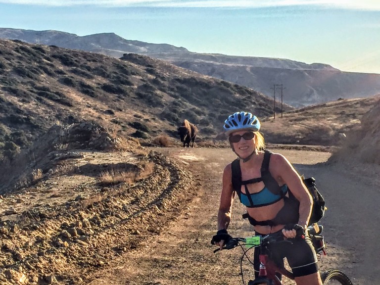
About Catalina’s Wild Buffalo

In 1924, 14 buffalo were brought to the island for a movie shoot and the rest, they say, is history. The bison thrived here and at one point the herd grew to 600. Today, the Catalina Island Conservancy  manages the population (via birth control) to about 150, thereby striking the balance between protecting the sensitive ecosystem and keeping the herd healthy.


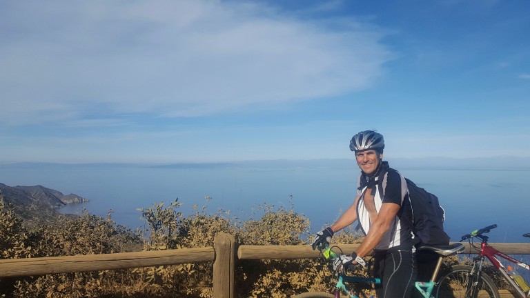
The weather was perfect and the visibility out to the mainland was the best I’ve ever seen it. Unfortunately, camera didn’t quite capture it. (Wasn’t going to bring my heavy Nikon.)

We made it just in time for sunset and the splendid wine and cheese welcome at the charming Banning House Lodge (another 150 ft climb) just to add insult to injury.

Big sigh of relief after our full, half-day adventure – brutal workout, spectacular views, a studly boyfriend who’s a great sport, a hot shower and a comfy bed – now that’s a birthday to remember. Stay tuned for Part II & III. (If you’re a mountain bike legend fan, you’re never going to believe who we ran into in the middle of the island on our way back to Avalon…)

Mt. Biking Noble Canyon, Pine Valley, CA: from Heavenly to Hellacious

Was gunho to get away to somewhere new this weekend. Perhaps a little too gunho…Wasn’t quite as thorough with the research as I usually am, but had done enough to know that the Laguna Mountain Recreation Area is a great spot for mountain biking and enjoying great scenery as you traverse 3 ecosystems: mixed-conifer/black oak forest, alpine meadows and desert.

And it certainly served up some heavenly single track around Laguna Meadow and beyond.


Sublime, right? And so it went for about 6 miles before things took a gnarly turn for the worse. Scattered rocks, became bulky blocks with jagged edges,  boulders and ankle bashing bruisers galore. I didn’t get pictures of these tortuous areas because, I was too miserable fending off hordes of face flies while hike-a-biking my hefty 35 pound bike. Even if I’d had a Go Pro, you wouldn’t have been able to see beyond the blur of flies – that’s how bad it was. Brutal – yes.

We only saw 2 other mountain bikers on the rough lower portion. They were wearing completely padded body armor suits with full face helmets. Another clue that I was way out of my element…I’m tough, but I’m not technical and have horrible eyesight and depth perception so this it was more than a bit hazardous. I’m extremely lucky to have escaped with only a handful of bruises and scratches.

( I later discovered – post-research – that this area is notorious among mt.bikers and is affectionately called Stairway to Hell and Roman Road.)

Here are a couple links to youtube videos on the area.

We kept looking for a route that would loop us back as a couple people at the trail head had mentioned, but we never found it. And there was no way we were going back up the Stairway to Hell…I even thought of abandoning my beater mt. bike and hiking out even though I only had my bikes shoes.


20170916_144652
A smile (or grimace) of relief after surviving Stairway to Hell

Instead, we made it out to the Pine Valley picnic area and then out the road. Realizing then that we would have to ride up the mountain via Sunrise Highway. Not much of a shoulder there, but a lesser evil than Stairway to Hell. Climbing 8 miles and 3K feet back to the car after the tortuous Noble Canyon was its own purgatory, and certainly, I’ve learned my lesson about doing my research. Perhaps next time, my BF will read the links I send him prior to departure too. (Snarkyness aside – selfreliance is critical even when you’re with a partner. If we both had read the trail reports thoroughly, one of us likely would have retained which trail to loop back on – though we still might not have found it…)

This day certainly put us to the test. Even though we both keep a fairly high fitness level – it kicked our butts. And to both our credits, we didn’t bite each others heads off. I did come close to meltdown with the face flies on attack while I was hefting my bike over boulder after boulder, but I held it together. We both did, taking the punishment mostly in silent, focused suffering. What was going to be a pleasant morning adventure, ended up being a whole day ordeal. Great workout – not so fun.

I’ve reread some of the trail reports and it sounds like there are other options if you want to avoid the burly section of Noble Canyon. I may be back, but need a cooling off period and time for my bruises to heal first.

Where: 40 minutes from downtown San Diego, near Pine Valley, off of Pine Creek Road North of I8 or off of Sunrise Highway to go top to bottom

What: Noble Canyon Trail, Laguna Mountain Recreation Area

Distance: 19.9 Miles out & back

Elevation  gain/loss: 3,346

Rating: For hiking: Moderate. For Mt. biking: Advanced+++

Notes: Adventure Pass required.

Tip: Bring bug spray and plenty of water. Consider a car shuttle for a 10 mile option. Given that it’s single track and a mountain biker destination, it’s not the most peaceful option for hikers…The trail head maps aren’t great, do your research first. ; )

Have you had any small adventures turn into challenging ordeals? Do tell.


A little slice of something nice: Annie’s Canyon, San Elijo Lagoon Ecological Reserve

If you live in the San Diego area or have visited, you’ve no doubt driven by picturesque San Elijo Lagoon Ecological Reserve countless times via the coast road or the freeway. Perhaps you’ve ventured on trails as well. I have, dozens of times for a run or stroll and I thought I knew all the trails there. (Pretty, but mostly flat and easy fare.) I hadn’t heard about Annie’s Canyon until someone asked me about it. Of course I had to investigate…

But first a couple words about these coastal wetlands. The reserve spans 1000 acres with a total of 7 miles of trails that connect the varied habitats from salt marsh to freshwater marsh areas to coastal sage and chaparral. Wedged between the freeway and the coast highway and surrounded on all sides by Solana Beach, Cardiff and Rancho Santa Fe, the lagoon remains home to more than 1,000 species of plants and animals – many endangered. Despite all the encroachment, it’s still a nice spot to savor nature and take in lagoon and ocean views.

Now for the unexpected delight of Annie’s Canyon. After a short, easy, less than mile hike to the canyon (look for signs), you’ll find yourself transported to a miniature canyon-land experience. Sure doesn’t feel like Southern California anymore, more like the slot canyons of Utah or Arizona. While it’s narrow, footing is fairly easy and there’s a steel ladder at the very top. Nothing treacherous here – just fun. It’s a super quickie (5 minutes), but super cool. What a great place to take young kids for a mini adventure with a little supervision and assistance. I know this kid at heart had some fun.

This slideshow requires JavaScript.

The view from the top. And no, it’s not a nudist colony, my hottie BF is wearing pants. ; )


Notes

Dog friendly in the lagoon – not so much for the canyon unless, they are trick pups trained to go up narrow steel ladders

No bikes

There’s a bunch of construction underway as part of the highway and rail improvements program in the North Coast Corridor. Click here for trail closure updates before you go.

Apparently this spot was previously vandalized and closed and has only recently reopened, which explains why I didn’t know about it. Please enjoy, respect and protect the nature around you.

Location

There are a number of entrances to the lagoon. Here’s ine

Solana Hills trail head address is 450 Solana Hills Drive, Solana Beach. From I-5, take the Lomas Santa Fe Drive exit (exit 37) West. At 0.2 mile  turn right onto Solana Hills Drive for 0.3 mile. Park along the dead end street. There’s also a great nature center on the Cardiff-by-the-Sea side, which is quite nice and you can rent it for private events.

Sun Valley, ID: Pioneer Cabin Hike

Tremendous hike in Sun Valley. Rewarding views, great workout, super cool cabin.

Distance: 8.5 miles                  Rating:  Difficult            Elevation gain: ~2,550 ft

Took the steady climbing Pioneer Cabin trail #122 up and descended the loop via the Long Gulch trail #123. Minus the snow and ice on the top and down the backside that we encountered, this would be a fantastic trail run. The terrain on 122 is pine needle smooth as you traverse 23 switchbacks through an old growth forest with glimpses of the Pioneer, Smoky, and Sawtooth Mountains through the trees. As you continue up into high alpine meadow, you’ll be rewarded with sweeping views .


But you’re not quite there yet. Just one more push and a panorama of peaks opens up and a rustic cabin welcomes you.

Pioneer Cabin was built by Sun Valley Company in the 1930’s to encourage Alpine skiing. (If I’d known the cabin was open, I would have made it an overnighter.) Underneath the snow, emblazoned on the roof greeting all those who ascend to its heights is its signature quote “The Higher You Get, The Higher You Get.”


Unlike trail#122, 123 is a bit tortuous, very rocky the last 2 miles or so.  Not to mention all the snow we encountered on that trail, but it was all so worth it! This hike makes most people’s list for the top ten in Sun Valley. It’s certainly tops with me.