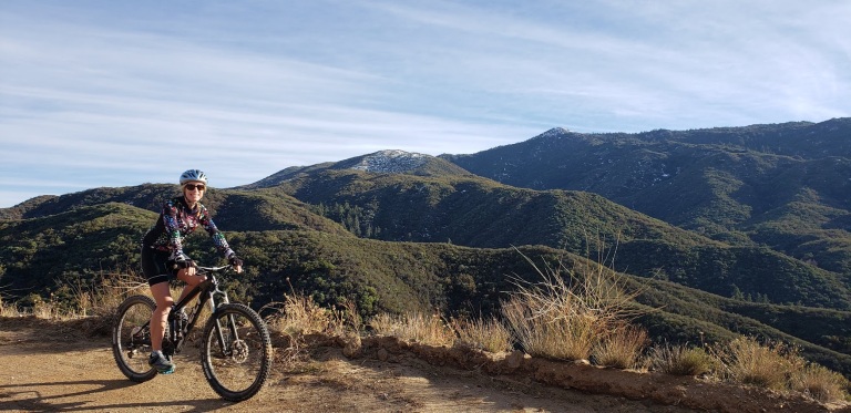
Bike up the backside of Palomar Mountain. Get a great workout while enjoying some solitude and splendid views of the San Diego back country, including Vail Lake and numerous snow-capped peaks (Thomas Mountain, San Jacinto, and San Gorgonio). This is nontechnical mountain biking at its best. If you like a climb with views, it’s a good one. Exceeded my expectations.
Their loss, our advantage.
When you can visualize a goal, you can attain it!
This slideshow requires JavaScript.
We turned around at mile 8 as the trail was getting muddy and we were running out of daylight. It’s worth coming back to finish it off. Will update this post when I do. Until then, let the good times roll! What a spectacular way to spend the first day of 2020!
Miles: 12 Miles / 24 Miles Roundtrip
Elevation: ~4,000 ft
Difficulty: Depends on your fitness level, knee health, and affinity for climbs. Very doable, the super steep sections are relatively short. Terrain has some rutty sections, but mostly good. This would also be a great trail run, or training for the Catalina Marathon, or any endurance races.
Directions: From Temecula, take HWY 79 east for 18 miles. Stay on HWY 79 and make a right 2/10ths of a mile past the junction of HWY 371 to an RV park/resort. Follow the paved road for 0.3 miles then park in the large dirt area in front of the Fire Service Road 8S05
Notes: There’s no water along this exposed route—plan accordingly. It’s hot during the summer and you may encounter snow during winter, or mud after heavy rains or melts. Vehicles are allowed on this route, but seasonal closures for motorized access often occur. (A bonus for mountain bikers and trail runners.) Further up the mountain, the Forest Service has labeled the High Point Truck Trail (8S05) as 9S09 between this junction and the Palomar Divide Truck. When in doubt, stay on the most “main” looking route.
Celebrity MTB Canine Sighting
Bonus: Be sure to top off your ride with a visit to Ricardo Breceda’s amazing outdoor gallery of metal sculptures. Also, check out his work in wild open spaces of Anza Borrego too!
A couple years back, I went for a pleasant mountain bike ride with a friend and have been wanting to return for a while. I couldn’t remember exactly where it was. Fortunately, my friend has a reliable memory and was able to direct me back to the spot. It’s part of the Coast to Crest Trail and in the San Dieguito River Park (92,000-acres)
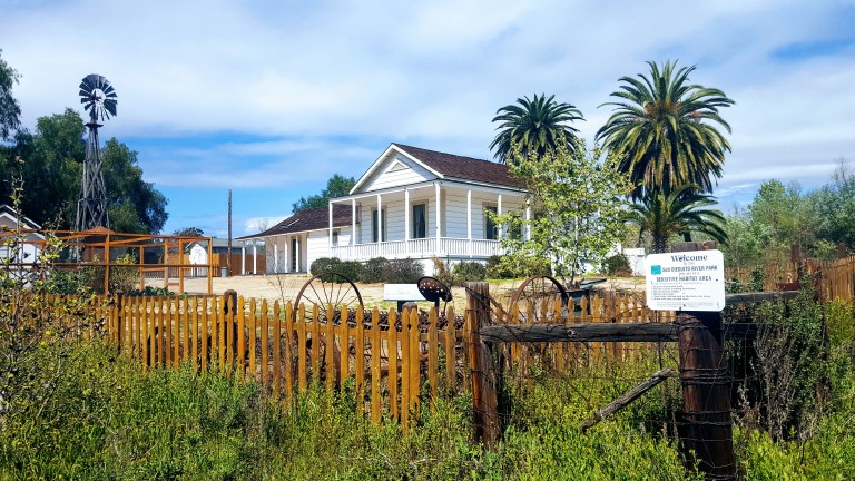
If you read my Lake Hodges MTB post, this spot is on the other side of the I-15 freeway. The trail begins at the historic Sikes Adobe.
Established around 1870, the Sikes Adobe Historic Farmstead is one of San Diego’s oldest adobe homes. Tours are offered on Sundays, more info here.
The first 3-4 miles or so are completely flat with easy terrain and valley views. Perfect for beginners and kids. Next you have 2 options, you can climb up some lovely single track to the Raptor Rodge lookout (and continue on to Ysabel Creek RD Staging Area) or cross the road to the Old Coach Trail and climb a steep paved road.
(I did both this time.) Previously, I had chickened out of the Raptor Ridge single track as it looked a bit rutted. This time it appeared smooth so I went for it and didn’t regret it. What a sweet ride, great for a trail run too. Only ran into 3 people out there despite a sign warning about congestion on the trail. It was gorgeous and a decent workout. Distance to Raptor Ridge is 6.1 miles ea way. The lovely valley views really open up as you climb. Once at the top, you can continue on down to the to the Ysabel Creek Road Staging Area, a somewhat rutted and scrappy fire road. Unless you have a car shuttle, you’d have to climb back up that road. I opted to return to the intersection and climb up the Old Coach Road instead. Once you navigate through the grove of trees and climb the steep paved road, you can continue to follow the Old Coach Trail signs across the 2 residential roads until you get to the single track. (I haven’t followed the single track to see where it goes as it’s gets a bit technical for me – trails is rougher, rocky, etc…) And the map ends at the paved road. Perhaps I’ll have the gumption to explore more next time.
This slideshow requires JavaScript.
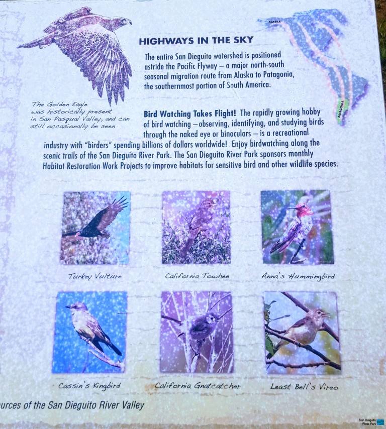
Raptor Ridge is aptly named. This area is great for bird watching.
Wonderful, well kept trails make for a splendid afternoon on foot or wheels. Gets hot in the summer so go early and bring water.
Getting there from the I-15:12655 Sunset Dr. Escondido
Exit Via Rancho Pkwy
Right onto Via Rancho Pkwy.
Right onto Sunset Dr. (1st traffic light from I-15N; 2nd traffic light from I-15S)
Left into the Sikes Adobe Staging Area (dirt lot ), or park along the street
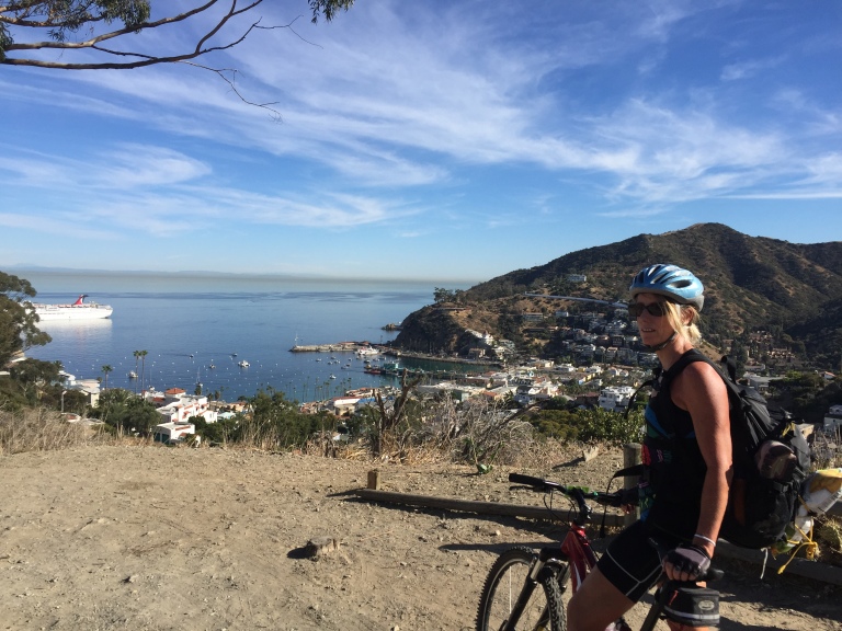
So I asked my athletic beau, Ken, “How about we take our mountain bikes to Catalina and ride from Avalon to Two Harbors, hang out and ride around there for a day, and then ride back? What do you think? ”
“Sure, sounds good,” he replied without blinking an eye…This is where I should have pulled out the disclaimers about the ~1700 foot climbs (that’s plural) that we’d be doing from sea level over the course of ~21 mile traverse across steep, unforgiving fire roads, and the fact that he’d be carrying a heavier pack than I…
I did dig out my old map of the marathon route with its epic elevation gains and losses, but he didn’t give it a glance. I declared with my usual exuberance, “It’s going to be a tough one, but it will be a great adventure!” You see, back in 2000, (yes, nearly two decades ago), I ran the Catalina Marathon, which takes you across some of the same routes so I had a distant, but visceral memory of how “challenging” the climbs on the island can be. (Decades of trail running has also taught me that’s it far easier to run up hills than it is to bike up them, especially if you are on heavy, beater bikes lugging packs on your back.) Of course, I’m nearly 2 decades older now and should also mention that we don’t mountain bike much (our last MTB adventure was Noble Canyon and we all know how that went. My bruises have finally faded,)
Bottom line, we both try to maintain a moderately-high fitness level for our weekend warrior and extended escapades and active adventures…(I’ve been focusing on yoga, swimming, hiking and a weekly road bike and he’s been running, and joining me for swims and road bikes as his schedule allows.) Unfortunately, I can’t run any more due to literally running out of cartilage in both my knees. Ugh, I know! For some reason, I thought I would be ok on the mountain bike with the hills…
About Catalina
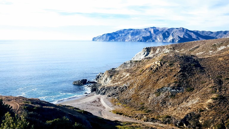
Catalina Island is a small (22 miles long & 8 miles at its widest point) rocky gem in the Pacific ~ 22 miles from Los Angeles, but thanks to nearly 50 years of the Catalina Islands Conservancy’s good work, it’s really worlds away! The island’s topography is a study in rugged beauty with steep cliffs and jagged coastline. Ninety percent of the island’s 4k population live in Avalon, which is also the Island’s major tourist destination with quaint shops, restaurants and bars. Yes, it has its charm, but you know by now that I’m more of a “wildlands” fan myself. That’s why we’re heading to the remote Westside of the island and staying in Two Harbors,
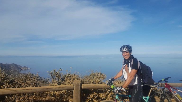
View point just after the initial climb out of Avalon on Stage Road – that’s the “What did I get us into this time?” look. Notice the over-packed backpack.
So I was wrong about that. Not long after the picture above was taken, 3/4 through the first climb from sea level up the airport road, I thought my knees were going to explode. No way I can make this, I thought. That’s when Ken pulled over and ordered me to empty everything heavy out of my pack and put it into his. I didn’t argue, toughing it out wasn’t an option if we were going to make it across. Yes, Ken is a stud and my hero! Wouldn’t have been able to make it without him taking on the extra poundage.
My hero, Ken, aka Superman, all smiles despite the extra weight in his pack. This is at the top of the first climb, he’s thinking the worst is over…I know we’ve only just begun.But views like these of the remote backside of Catalina can turn even my worst grimace into a smile…
We left Avalon after 1PM and we didn’t pass the halfway mark until 3PM with all my knee breaks so we were getting a little worried that we might not make it by dark. There were no hikers or bikers out except for us and only a few cars and Island Conservancy trucks passed us. We had decided not to camp as we’d be carrying the weight of sleeping bags and Thermarests and possibly a tent too. Instead, we decided to treat ourselves to a stay at the Banning House Lodge for both our recent birthdays. So instead of stopping and relaxing at one of these gorgeous deserted beaches we pushed on and on…
We came around a corner and a gorgeous Catalina Fox crossed in front of Ken. Unfortunately, my camera was in my backpack and getting it out would have scared it away so we both just sat still and watched in quiet wonder as the beautiful creature took 5 steps looked back at us, took five more, looked back again, and once more before disappearing into the roadside brush. As if to say, “Hey, I’m giving you guys plenty of photo ops, what’s your problem?” This would be the first of several fox sightings in which I would be camera cursed each time. (Luckily, we met a great couple from Carlsbad (John & Julie) who caught some great pics while we were having dinner together at Harbor Sands. Stay tuned.)
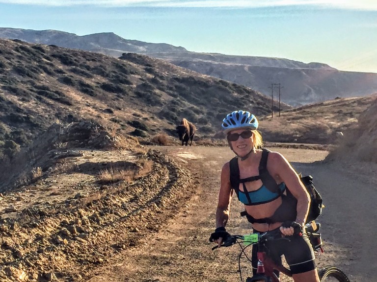
We would have one more notably larger critter encounter on our final climb out of Little Harbor, a brute of a buffalo was snorting and drooling his way up the hill. He was on the far right. We stayed as far left as we could.
Buffalo can charge at 35 mph and jump 6 feet high. And, we were told later, not unlike other aggressors, they have a thing for bikers. Yes, yikes. That’s my “Forget the picture and let’s keep moving.” look.
About Catalina’s Wild Buffalo
In 1924, 14 buffalo were brought to the island for a movie shoot and the rest, they say, is history. The bison thrived here and at one point the herd grew to 600. Today, the Catalina Island Conservancy manages the population (via birth control) to about 150, thereby striking the balance between protecting the sensitive ecosystem and keeping the herd healthy.
The weather was perfect and the visibility out to the mainland was the best I’ve ever seen it. Unfortunately, camera didn’t quite capture it. (Wasn’t going to bring my heavy Nikon.)
We made it just in time for sunset and the splendid wine and cheese welcome at the charming Banning House Lodge (another 150 ft climb) just to add insult to injury.
Big sigh of relief after our full, half-day adventure – brutal workout, spectacular views, a studly boyfriend who’s a great sport, a hot shower and a comfy bed – now that’s a birthday to remember. Stay tuned for Part II & III. (If you’re a mountain bike legend fan, you’re never going to believe who we ran into in the middle of the island on our way back to Avalon…)