Adventures Near & Far, St. George Yoga & Hike Retreats, Popup Yoga, Local Guiding
Search Icon
Author: livevigorously
Greetings, I’m a St. George local who is passionate about blending my love for yoga, and the great outdoors to create an unforgettable experience just for you. Enjoy outdoor yoga (all levels) in an iconic setting and/or a guided hike to secret petroglyphs, caves, and slot canyons. With stunning Snow Canyon as my backyard, I'd love to be your guide to the best this area has to offer! Ask about my "home stay" options.
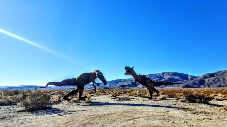
Thanks to the owner of Galleta Meadows Estate, Dennis Avery, there’s an incredible al fresco metal art sculpture exhibition to be discovered in Anza Borrego. Over 130 metal sculptures created by artist/welder Ricardo Breceda seem to appear out of nowhere in the barren, dramatic landscape. With a little imagination, you’re transported to the prehistoric times of dinosaurs, mastodons and saber-tooth tigers.
The exhibition spans about 10 square miles. Many of the sculptures can be seen from the road; others require some driving, hiking or mountain biking in on sandy roads. Some are in clusters, others quite spread out. You never now what kind of creature you’ll encounter next. Highlights include a giant scorpion, a 350 foot-long sea dragon and so many more. I’ll leave you to discover the rest yourself. My favorites, as you can tell, were the prehistoric sculptures.
It’s definitely worth seeing and no doubt a blast for the kids.
Getting there: Take the S22 into Anza Borrego and cruise the valley looking at both sides of the road. (If you want a guided map for the sculptures, you can pick one up at the visitor center in town.)
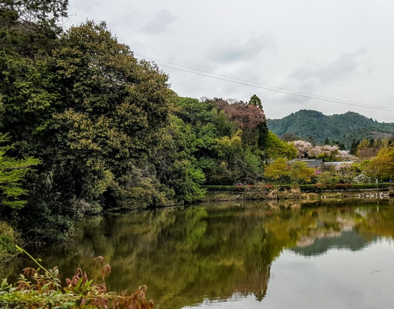
Whether you explore the historic Arashiyama District by foot, bike, boat, rickshaw or all of the above—it’s a Kyoto must do. Along the lovely scenic paths are temples, shrines, a bamboo forest, artisan shops and restaurants. Read on to discover the top 3 things to do in the area.
Wow, those strong legs!
Many of the signs are also in English so it’s easy to navigate.
You’ll pass through residential areas as well and see people going about their daily routines, sweeping the streets with handmade brooms, tending their gardens, etc.
I love that the Arashiyama District is very walkable and bikeable with something new to see around every blossom-lined corner. It easy to see why this charming area is one of the most popular sightseeing districts in Kyoto.
Plan on spending a half or full day here, soaking in the sights, shopping and getting a taste of the culture and cuisine. If you only have time for two quick stops, you’ll want to check out the Bamboo Forest and the Tenryu-ji Zen Temple. If at all possible, make the time for a leisurely explore and include an excursion on the Hozu River. You’ll be glad you did.
Arashiyama Bamboo Forest
Disapproving mother-in-law lurking in the background?
While many say that this bamboo forest is the “star” attraction of the Arashiyama District, I was a bit underwhelmed by it (crowds and a path running through it).
Tenryu-ji Zen Temple One of the Top 5 Zen Temples in Kyoto, this temple has an amazing Zen garden that dates back to the 14 Century. The beautiful garden features a pond that is framed by maple trees, rocks and mountain views. Admission Fee: ~$5
This slideshow requires JavaScript.
Hozu River You can take a short scenic boat ride here or start from nearby Tanba-Kameoka (16K away) and embark on a leisurely two hour boat ride that takes passengers down the winding Hozu River to Arashiyama. Unfortunately, I didn’t have time, but it sounds like a wonderful experience – self propelled on a rental canoe or escorted.
Cheers to another memorable day in Kyoto.
Getting there: Take the JR Sagano (also known as JR San-in) Line from Kyoto station to JR Saga-Arashiyma station.The local and express (or limited) lines are on platforms 32-35. The express makes 3 stops, local makes 6. It approximately a 15 minute ride and costs ~$3.
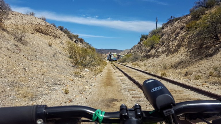
Deep in the heart of the Jacumba Mountains overlooking Carrizo Gorge in Anza Borrego State Park, you’ll find the Goat Canyon Trestle. Getting to the world’s largest curved wooden trestle is like being transported to the wild west of days done by. You’ll traverse dark tunnels in various stages of collapse, dodge rock slides, narrowly avoid precipitous drops into rock canyons, explore abandoned trains and endure the blazing desert sun. If this is your idea of fun, read on. Ok, it’s not that bad. In fact, it’s an easy, flat mtb cruise or a longish flat hike through some very cool (pun intended) desert terrain.
(Video credit and pics I’m in below: Ken Wells)
It’s slow going as there are several points where you have to lift your bike over one obstacle or another. You can’t speed through because you never know what’s around the next corner or if the bottom might drop out in front of you.
Be alert and cautious all the way out and back. Headlamps are a must for the tunnels, lots of obstacles in there. Workout-wise, it’s easy – safety-wise, it could be considered a bit sketchy.
As you bike along the railway, sometimes the path is quite narrow with a precipitous drop into the rocky canyon below. A moment of distraction could make for a very bad day. Wouldn’t suggest mountain biking for kids here, unless they are quite skilled and cautious riders.
Up close, the trestle seems a bit rickety, like a skinny, dilapidated Jenga set.
This slideshow requires JavaScript.
Background: The trestle was built in 1933, as part of the San Diego and Arizona Eastern Railway, aka “the impossible railroad” that ran through Baja California and Eastern San Diego County and ended in Imperial Valley. Over the years, collapsed tunnels and rock slides plagued the railroad, including the collapse of Tunnel 15, which led to the creation of the trestle. The trestle was constructed of wood (no nails used), rather than metal due to the area’s extreme temperature fluctuations, which can lead to “metal fatigue” / failure and it was designed with a 14 degree angle to offset Goat Canyon’s high winds. By 2008, rail traffic had ceased. As recently as last year, another tunnel, Number 6, near the trestle collapsed…(Yikes.)
Distance: Roundtrip 10 -14 miles, depending on where you start
Getting there: 8E from San Diego, take the Jacumba Exit
Parking: Park for free in the dirt lot right off the freeway at the Jacumba exit and follow the dirt portion of Carrizo Gorge Road 2 miles towards the DeAnza Spring Resort, the largest “clothing optional” resort in North America. Optionally, pay $5 to park at the resort. 1951 Carrizo Gorge Rd. There’s a Subway & gas station right off the freeway. You can also grab a bite & beer at the resort after your ride…
Note: This is the desert, plan accordingly – ample water, sunscreen, hat, etc…
A couple years back, I went for a pleasant mountain bike ride with a friend and have been wanting to return for a while. I couldn’t remember exactly where it was. Fortunately, my friend has a reliable memory and was able to direct me back to the spot. It’s part of the Coast to Crest Trail and in the San Dieguito River Park (92,000-acres)
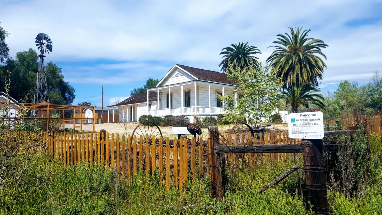
If you read my Lake Hodges MTB post, this spot is on the other side of the I-15 freeway. The trail begins at the historic Sikes Adobe.
Established around 1870, the Sikes Adobe Historic Farmstead is one of San Diego’s oldest adobe homes. Tours are offered on Sundays, more info here.
The first 3-4 miles or so are completely flat with easy terrain and valley views. Perfect for beginners and kids. Next you have 2 options, you can climb up some lovely single track to the Raptor Rodge lookout (and continue on to Ysabel Creek RD Staging Area) or cross the road to the Old Coach Trail and climb a steep paved road.
(I did both this time.) Previously, I had chickened out of the Raptor Ridge single track as it looked a bit rutted. This time it appeared smooth so I went for it and didn’t regret it. What a sweet ride, great for a trail run too. Only ran into 3 people out there despite a sign warning about congestion on the trail. It was gorgeous and a decent workout. Distance to Raptor Ridge is 6.1 miles ea way. The lovely valley views really open up as you climb. Once at the top, you can continue on down to the to the Ysabel Creek Road Staging Area, a somewhat rutted and scrappy fire road. Unless you have a car shuttle, you’d have to climb back up that road. I opted to return to the intersection and climb up the Old Coach Road instead. Once you navigate through the grove of trees and climb the steep paved road, you can continue to follow the Old Coach Trail signs across the 2 residential roads until you get to the single track. (I haven’t followed the single track to see where it goes as it’s gets a bit technical for me – trails is rougher, rocky, etc…) And the map ends at the paved road. Perhaps I’ll have the gumption to explore more next time.
This slideshow requires JavaScript.
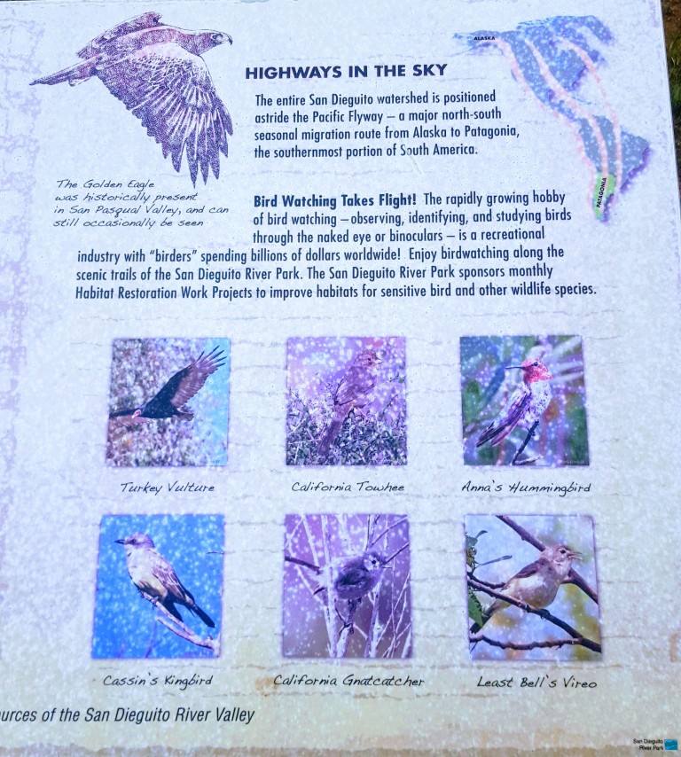
Raptor Ridge is aptly named. This area is great for bird watching.
Wonderful, well kept trails make for a splendid afternoon on foot or wheels. Gets hot in the summer so go early and bring water.
Getting there from the I-15:12655 Sunset Dr. Escondido
Exit Via Rancho Pkwy
Right onto Via Rancho Pkwy.
Right onto Sunset Dr. (1st traffic light from I-15N; 2nd traffic light from I-15S)
Left into the Sikes Adobe Staging Area (dirt lot ), or park along the street
Cowles Mountain (1,593-foot summit) is the highest point in the city of San Diego. It’s part of Mission Trails Regional Park, a 5,800-acre open space preserve that is the 7th-largest open space urban park in the United States. It contains sixty miles of hiking, mountain bike and equestrian trails.
To call Cowles a mountain is to be very liberal with the word. I should note that the park has a 5 “peak” challenge if your hiking peeps want a minor challenge and want to document your feats – here’s the scoop. Cowles is the highest peak. This might be fun for kids, but apparently lots of adults do it for bragging rights too. I will say that on a clear day, the stunning views span 360 degrees from Lake Murray, downtown San Diego, Point Loma, La Jolla, and Mexico and out across the glimmering Pacific to the San Carlos Islands. See feature picture above. (Unfortunately, I dropped my camera on a rock so I have limited pics.)
Distance: 2.9 miles up & back
It’s a very popular trail so expect lots of humans and their canines…There are a couple of different ways to reach the top from various starting points and parking lots. The hike itself is moderate (with some steeper sections that will get those calves & glutes burning). It’s decent workout, especially if you run it. There are single track trails and some fire road. It’s short from any direction so I explored up and down on a couple of trails and was a little disappointed that there wasn’t more to see. You can’t really get lost so do as much or as little as you like.
Getting there:
The main trailhead is in the San Carlos neighborhood on the corner of Golfcrest Drive and Navajo Road
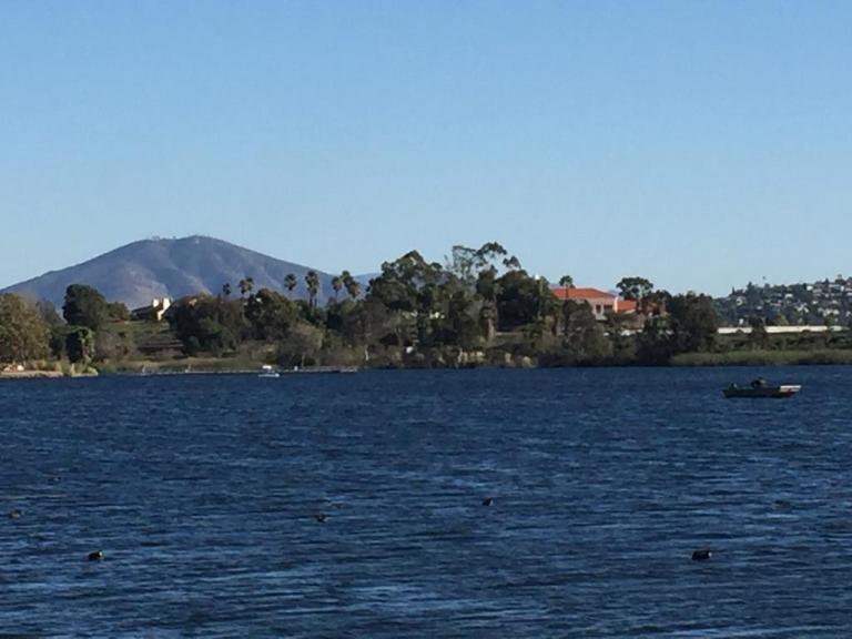
Lovely Lake Murray
Since I didn’t quite get enough enough of a workout / nature fix, I decided to check out alluring Lake Murray Reservoir, also part of the Mission Trails Regional Park. I strolled the paved road that navigates around most of the lake stopping short of the dam (no access). It’s another popular spot – walkers, runners, bladders, and even road bikers aplenty (the latter seems silly to me, because the path / road is only 3.2 mi long and there are many children and dogs on it).
Lake Murray is a great spot for birdwatchers with abundant ducks, geese, and herons abound and about 149 bird species to observe. It’s a pleasant spot for a picnic too.
Go Fish
Lake Murray is open for shore fishing and private boats, kayaks, and float tubes seven days a week from 5:30 a.m. to 8:00 p.m. Permits can be purchased onsite at the iron ranger boxes. The lake is stocked with Florida-strain largemouth bass, bluegill, channel catfish, black crappie, and trout. Minimum size limit for bass is 12 inches.
Fish limits: 5 trout, 5 bass (min. 12 inches), 5 catfish, 25 crappie and bluegill total, no other species limits


")
")


 Cheers to another memorable day in Kyoto.