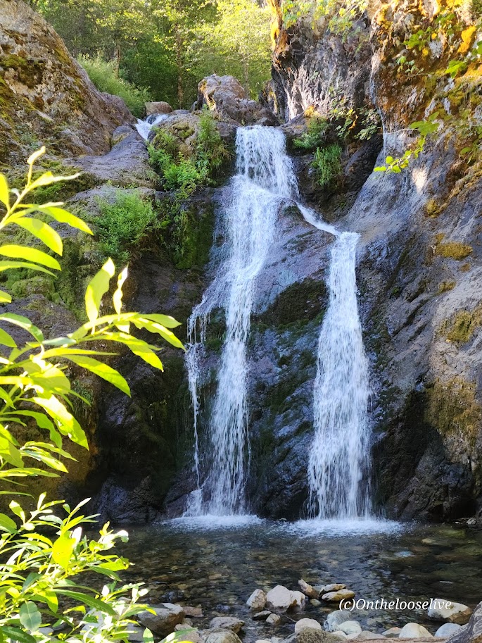
Sometimes enchantment is just a short stroll away, as is the case with Faery Falls. Nestled in the Shasta-Trinity National Forest, Faery Falls is an easily accessible, enchanting waterfall that drops about 50 feet into a small pool. The short, easy hike on a dirt road above Ney Springs Creek passes a few stone remnants of the fountain from the old Ney Springs Resort. Watch for the single-track drop-in trail to the waterfall on the left at .8 mile. Some have described this final section as difficult – in adverse conditions such as mud, snow, or ice, it could be. In dry conditions with appropriate shoes, it’s no problem.
The falls area is small and enclosed by rocks and trees. It can become crowded quickly. Especially important to go early on a weekday if you want your best chance of solitude. Luckily, I was there early and had it to myself.
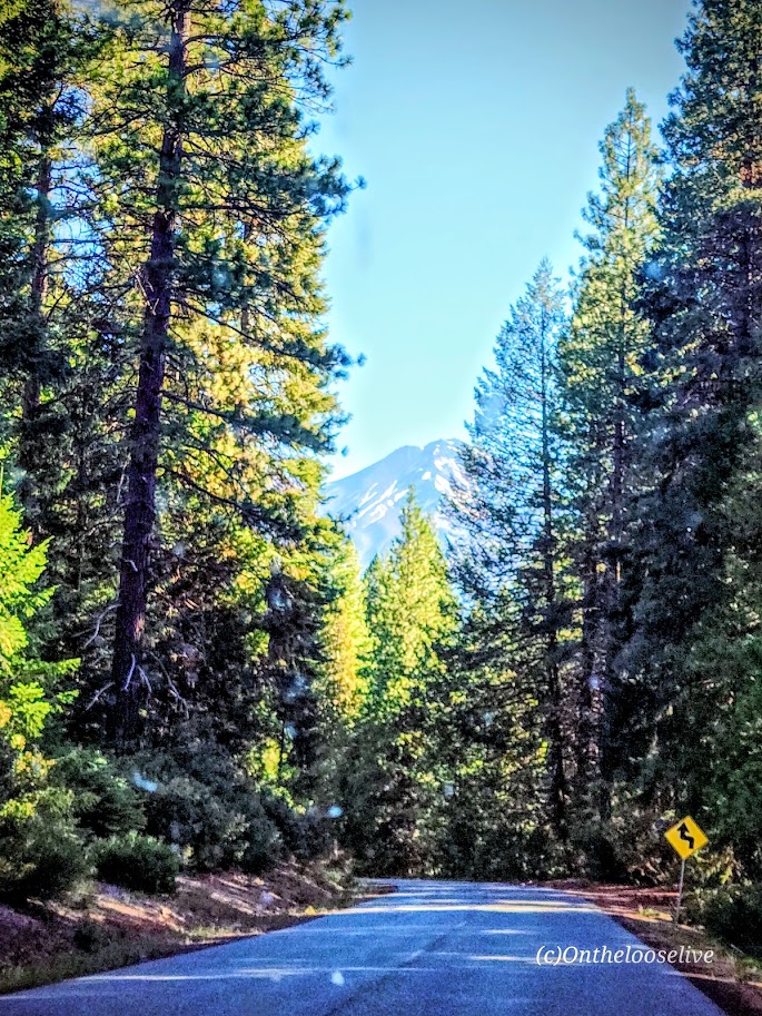
Views of Mt. Shasta on the way to the trail. Not sure what the rooster was doing there. Perhaps a pet from the VW double bus?
Notes: The Faery Falls “Trail” is the dirt road to the right of the large parking lot. Parking is free! This hike is easy to combine with the Castle Lake Trail to Heart Lake and beyond. (Post to come!)
Trailhead address: Ney Springs Road, Mount Shasta, CA 96067 Trailhead coordinates: 41.265953, -122.32439 (41° 15′ 57.43″N 122° 19′ 27.80″W)
Pro tip: Stop at Theory Coffee in Mt. Shasta City on the way in or out. They served me the BEST post-hike brioche breakfast sandwich I’ve ever had! It’s a bakery too, with incredible delights on display. (Didn’t get a shot of them as I was too busy drooling!)
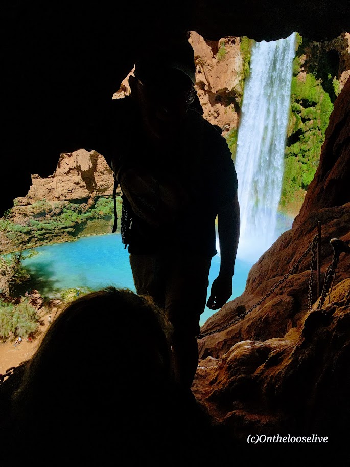
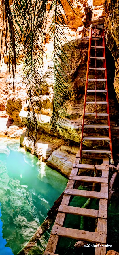
The descent to Mooney Falls requires ducking through a narrow, low sandstone tunnel carved into the cliffside, followed by cautious navigation down eroded and slippery sandstone “footholds” to the ladder far below. While there are chains bolted into the rock for handholds in the most exposed sections, even with them, it feels a bit sketchy. The new wood ladder was slick with mud and mist, and its rungs were spaced wider than a comfortable leg stretch for me. With 6 years of rugged hiking, scrambling, and the occasional canyoneering adventure in Utah under my belt, you’d think I’d have less trepidation navigating this than I did in my younger years. But still, it gave me moments of pause. (On the way back up, I saw a toddler and a young boy scramble ahead of their parents up the cliffside. Yikes!)
The power of the waterfall and the amount of mist the rushing water created were tremendous! The sunlight through the mist caused a magical effect in my photo on the right.
Beaver Falls
~3 Miles from Mooney Falls
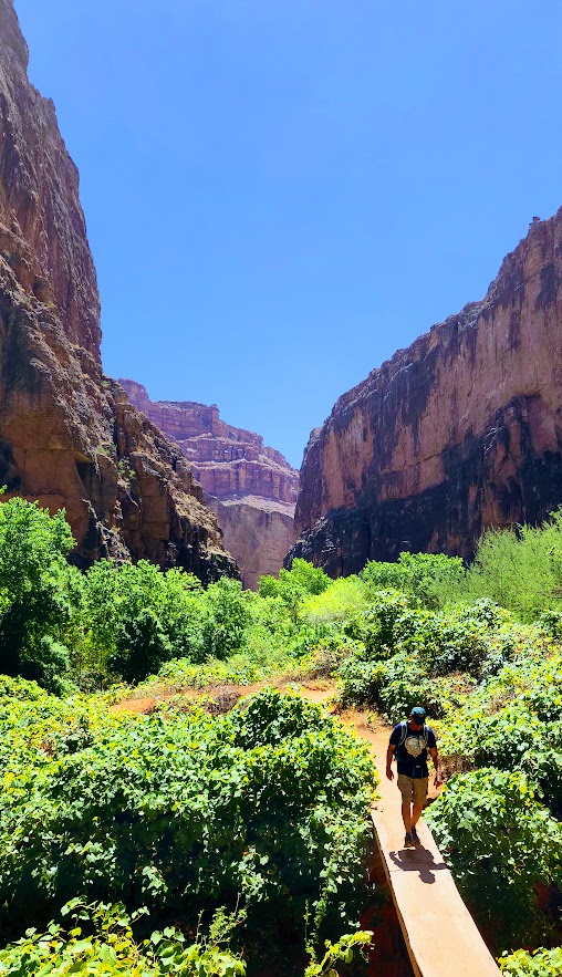
I’d never ventured beyond Mooney Falls before—there was never enough time. So I was especially grateful for the chance to explore further on this trip. The 3-mile hike from Mooney Falls to Beaver Falls is both enchanting and engaging, winding through a lush corridor of vines and trees along the turquoise creek. It feels like stepping into a jungle, with hidden oases revealing themselves around every bend.
After a few refreshing creek crossings, the trail leads you through a striking sandstone archway to a short make-shift mini-bridge water crossing, followed by a ladder cliff climb. Thankfully, the footing here was drier and more stable than the slippery ladder at Mooney Falls.
Beaver Falls was truly stunning—cascading tiers of turquoise water —but it was also crowded. I hardly took any photos. A brief moment of uninterrupted zen there below.
Thankfully, there were plenty of quieter “private” oases along the way, perfect for a peaceful dip or simply taking a moment to soak it all in. Beaver Falls is absolutely worth it, and the hike to it is fun—just be sure to get an early start if you’d like to experience it in solitude.
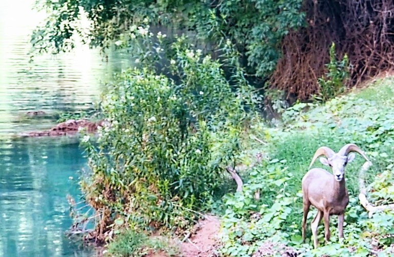
On the hike back, it was nearing critter hour. Much to my surprise, a bighorn sheep was just off the trail, seemingly scouting out a peaceful spot by the water to settle in for a nap. I had no idea that there were big horn down here!
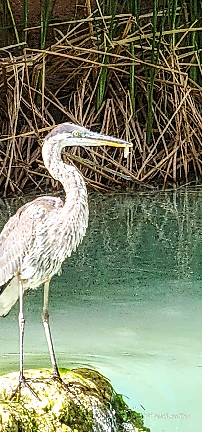
Closer to the campgrounds, I spotted a blue heron, focused, mid-hunt—clearly having some luck with its evening catch. Pics are a bit blurry due to distance.
Leaving Eden
We started our return hike from the village just after dawn, hoping to beat the heat. Fortunately, most of the trail remained shaded until the final climb out of the canyon, which is fully exposed. Fortunately, there are a few rocky overhangs along the way—perfect spots to catch your breath and escape the unforgiving sun for a moment.
This adventure was nothing short of epic. I felt a pang of sadness as it came to an end, but also immense gratitude for the chance to return (thanks to my friend Bernie for securing the permits) and the opportunity to explore more than I ever had before. Among all my adventures near and far, the exquisite beauty and spiritual essence of Havasupai will forever hold a special place in my heart. I’ve never experienced anything quite like it. It remains one of my all-time favorites.
I’ve had the privilege of visiting this sacred Eden three times before. The first time was in 1993. I’ve hiked in, camped twice, and stayed at the Lodge—now twice. On one of those trips, a friend surprised me with a scenic, 10-minute helicopter ride back up to the rim. (He wasn’t keen on hiking out with a pack—or waiting while I did—so I scored my first helicopter ride, a quick thrill in exchange for sacrificing a good workout.)
Those earlier trips were quick overnights, back in the day—before permit complications and prohibitive costs. And two of them were after recent flash floods, so the water was churning chocolate.
While still awe-inspiring in any state, the falls are much more magnificent in their rushing turquoise glory.
In all my worldwide adventure travels, Havasupai and its falls remain unmatched. I’m so grateful that I had the opportunity to experience this special place again.
Background
Havasupai Village at the bottom of the south rim of the Grand Canyon is considered one of the most remote Indian Reservations in the country. The Havasupai Native American tribe has lived in the Grand Canyon for ~ 800 years. The name Havasupai translates to “people of the blue-green water” and refers to the stunning turquoise waters of Havasu Creek and its spectacular waterfalls (Navajo Falls, Havasu Falls, Fifty-foot Falls, Mooney Falls, Beaver Falls). The water’s surreal turquoise hue comes from a high concentration of calcium carbonate (lime) in the water. Over time, the lime deposits build up around sticks, leaves, and other debris, forming natural terraces that add to the spectacular landscape.
Why Pay the Price?
Words can’t begin to capture the magic and spiritual energy of this place. Yes, the most popular waterfalls—Havasu Falls, Mooney Falls, and Beaver Falls—draw the crowds. But the good news is, tucked along the trail are hidden oases that you can have all to yourself. Hopefully, the pictures speak for themselves.
Day 1: Grand Canyon Rim to Havasupai Village and Havasu Falls
Distance to Village: 8 miles Elevation Loss: 2,500 Ft
Circa 1998 vs 2025. It’s hard to out 6-pack my younger self, but I’m still trying and still finding as much or possibly more joy in my active adventures.
The hike down from the rim, through the dry Hualapai Wash and into the village via the Havasupai Trail, may feel unremarkable to those familiar with other Grand Canyon hikes.
Aside from a few interesting rock formations, the trail is mostly a sandy, gravelly, waterless, hot, dusty, potentially blister-inducing slog.
(1993 and 2025 – same spot, but there must have been an enormous rock slide, as you can see the huge slabs to the right of me in the recent pic !)
But of course, every step is 100% worth it! (Just be prepared with ample water, sunscreen, hat, moleskin, etc.)
Distance to Havasu Falls from the Village: ~4 miles RT
The pic below is from my first visit in 1993.
After grabbing a bite at the restaurant, we dropped our bags at the lodge and made a beeline for Havasu Falls—one of Havasupai’s crown jewels.
The lovely views begin about a mile from the village.
Havasu Falls was even more breathtaking than I remembered. The only thing better than marveling at its splendor is immersing yourself in it.
What’s Changed
As mentioned, the costs of visiting this sacred place have skyrocketed. It has been dubbed the most expensive hike/camping trip in America.
As of July 2025, it’s $455 per person for a 3-night stay at the campground and $2,277 total for a 3-night stay at the lodge in a double room. Note it’s a mandatory 3-night payment requirement in both cases—no refunds for shorter stays. For the luxury of having a mule carry your pack, it’s $400 RT for up to 4 bags; each bag must weigh less than 32 pounds. All I can say is if the system keeps the crowds down and supports the locals, I’m for it.
The cost of a helicopter ride to/from the village is $150 per person each way, with the additional cost of $50 per pack/bag.
The Good
I noticed more families and younger locals living in the village than my past visits, a shift that reflects community renewal. There’s now a Head Start program for young children and a new, modern medical clinic. The Lodge has been renovated as well; the air-conditioned double rooms are clean and updated, featuring comfortable beds, a fridge, and a microwave.
The village restaurant has also been upgraded. Its expanded menu now includes healthier options like salads and grilled chicken sandwiches, alongside traditional frybread and the usual burger-and-fries fare. Barstools at a large window offer a front-row view of the village center—including the regular whirlwind of helicopter landings and takeoffs with their sudden sandstorms and dust clouds.
There also seemed to be far fewer dogs roaming the village than in past visits—and the ones I did see appeared relatively healthy. I want to be clear: I understand that when people are struggling with basic necessities, pet care can’t be a priority. Still, in previous years, the heartbreaking sight of malnourished nursing dogs and sickly puppies left a lasting impression that deterred me from visiting again – until now. ( A friend secured the permit, and when he offered me the opportunity, I couldn’t refuse.)
Those images stayed with me—not in photos, but in memory. Possibly in response to past negative press surrounding animal treatment here, a strict no-photography policy now applies to pack animals and dogs, as well as the village itself and its residents. This is entirely understandable to protect the villagers’ privacy, dignity, and culture.
The Bad—Paradise Lost?
I’m not sure how long ATVs have been in use in the village, but they seem to be increasingly popular with locals. While I understand their practicality—and, no doubt, their fun—they do detract from the experience, especially in such a remote and natural place. The noise, dust, and trail erosion are hard to ignore. A local woman I spoke with shared her unsolicited disapproval of them.
The Ugly—Soapbox Warning
What disturbed me most on this trip, though, was the amount of trash—mainly empty plastic water and Gatorade bottles—littered everywhere along the Havasupai Trail—literally a Trail of Trash. I don’t recall seeing anything like this on previous visits. Next to animal welfare, littering is my “pet peeve”.
I honestly don’t understand it. People are paying a premium to visit this incredible place—yet they are disrespecting it and the locals by littering? Yes, hiking in the heat with a heavy pack is tough, but these bottles are empty. Carrying them out takes almost no effort. What the heck, people? Who does this? It’s truly appalling.
Thankfully, there’s noticeably less litter in the campgrounds and around the waterfalls—likely thanks to regular cleanup crews and maybe because the Instagrammers don’t want to tarnish their photos there. But the trail itself deserves the same care and respect. This place is a treasure, and it deserves better from all of us.
Despite the cons, there are still moments of paradise here for me. What about you?
What’s the Solution?
Havasupai should implement steep penalties for littering—$1,000 fine—and use the revenue to fund a dedicated litter patrol program employing local workers. Another idea: offer small incentives to visitors who pack out the trash they collect along the trail—perhaps a discount at the restaurant, Lodge, or campground. (Though yes, I know… someone will always try to game the system by raiding the trash can near the village.)
I’m just brainstorming here, trying to imagine practical solutions to this heartbreaking issue. I will never understand how people can journey to such an awe-inspiring place only to defile it with trash. It makes no sense.
If Arizona adopted a “bottle bill” like some other states—placing a refundable deposit on bottles and cans—I have no doubt it would reduce the problem dramatically. Short of that, maybe they could offer an off-season camping weekend in exchange for a few hours of supervised trail cleanup. A give-back program for those willing to help restore what others have damaged.
Although the “Leave No Trace” policy is clearly stated in the reservations paperwork, including a $1,000 fine for leaving trash or gear behind, I didn’t see any signage reinforcing this policy on the trail or at the campgrounds. What I did see, unfortunately, was tons of litter. Posting visible reminders about the rules and the consequences might help discourage the defilers.
Perhaps the tribe could also consider installing designated trash receptacles at key points, with a budget allocated from the high permit fees to manage its removal. I understand the original goal of a strict pack-in/pack-out system, but it’s clearly not working. I’d be very curious to know how many fines have been issued—and whether those funds have gone back into trail maintenance or cleanup efforts.
What do you think would make a difference?
So that’s the good, bad, and ugly of it. Is it worth it still? Emphatically 100%!
Plan Ahead: Permits are hard to get. Camping permits are available from February 1 through November 30, and reservations for the Lodge are available from April 1 through November 30. The area is closed in December and January.
Permits go on sale February 1 at 8 AM Arizona Time/Mountain Time. Up to 12 people can be on a camping permit for $455 each. If you don’t land a permit on February 1st, you can check in their transfer page, where newly available permits are listed daily at 8AM.
In 2025, there was a 2-week presale from December 16 to January 3. You pay a non-refundable $20 per person fee for the chance of securing one of your 3 reservation start times. If you win your permit, you’ll then pay the full price of either camper or lodging reservations. (Permits are only transferable through the official website.)
Note, Havasupai can close unexpectedly due to flash floods. Monsoons are frequent in the summer months. Pay attention to the weather forecasts.
Since there is no refund policy to cover this or any other eventuality, you may want to consider securing travel insurance before your trip.
Before you begin your hike, the designated trip leader must check in at Grand Canyon Caverns Inn to pick up the required documents and bag tags the night before or by 12 noon the day you wish to hike in; otherwise, your reservation will be canceled.
Stay tuned for the videos and the Mooney and Beaver Falls post.
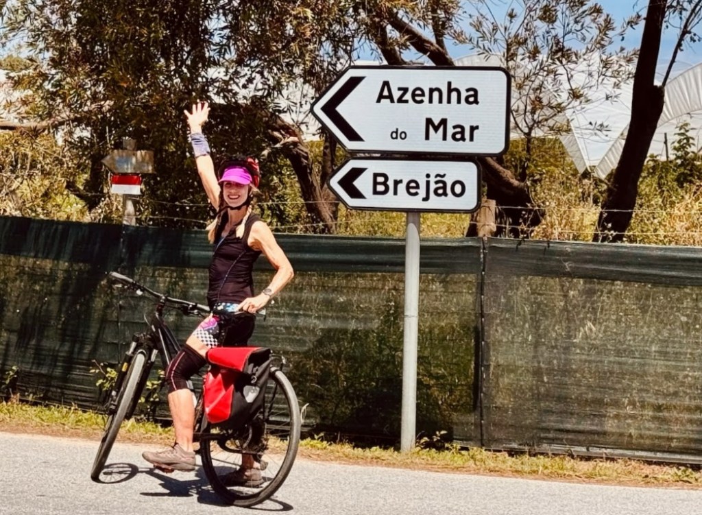
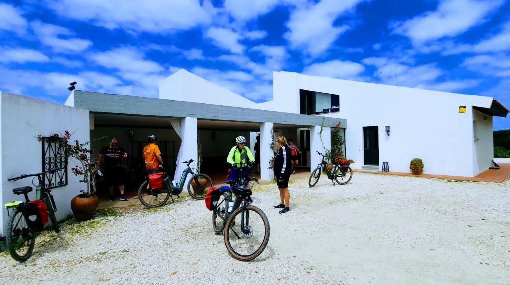
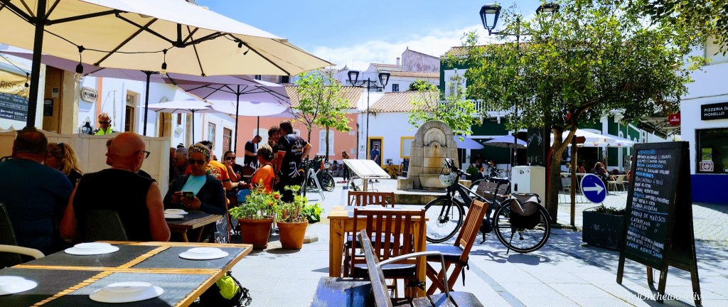
After a solid night’s sleep and another heavenly breakfast buffet, we hit the road for biking day 3 with Top Bike Tours Portugal.
We rolled through peaceful countryside and farmland on a mix of paved roads and dusty trails.
After huffing our way up a steep cobblestone hill —legs burning (well, those of us on regular bikes that is), spirits high—we were rewarded with a surprise at the top: a cluster of unlikely expats appearing like a mirage. Apparently, residents of the Safari Lodge Kuanza.
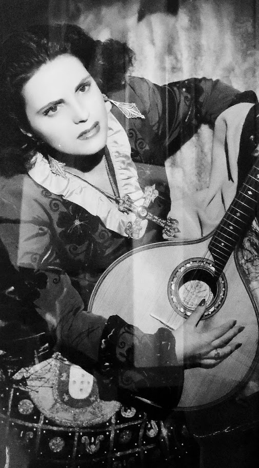
Our next surprise was a private tour of the legendary “Queen of Fado”, Amália Rodrigues’ spectacular cliffside estate. Telmo casually tapped in the code at the remote entrance gate and guided us in. Privileged!
Amália wasn’t just a singer; she was a force of nature. A poet, lyricist, actress, and Portugal’s most iconic voice, she poured raw emotion into every note of Lisbon’s soulful folk music. Her songs of longing and love captivated not just Portugal but the entire world, earning her accolades and honors from every corner of the globe.
Before the grand house took shape in the 1960s, Amália made her home in this cozy “cottage” tucked into the property.
Sign me up! Is there a more splendid setting than this for a B&B? Imagine waking up to the sounds of waves crashing into the shore of the rugged wild beach below, and surveying the last untouched, preserved coastal stretch of the Algarve, Vicentina Coast Natural Park. Oh my! If you’re in the area, I highly recommend that you book a room or at least take a tour.
The estate is hosted by Amalia’s charming cousin and engaging storyteller, Antonio Felipe Gomes, who gives tours and shares highlights and personal anecdotes of Amalia’s life and legacy.
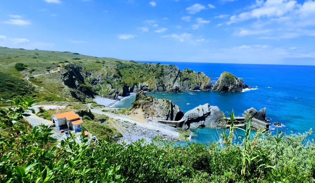
From “Herdade Amalia’s”, we continued our cycling journey along dirt roads with grand views of the coast, whitewashed houses, and verdant countryside.
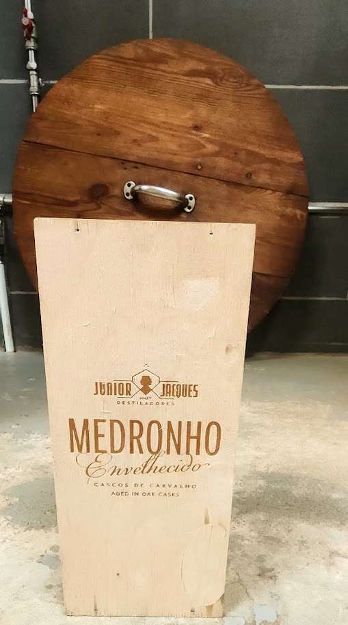
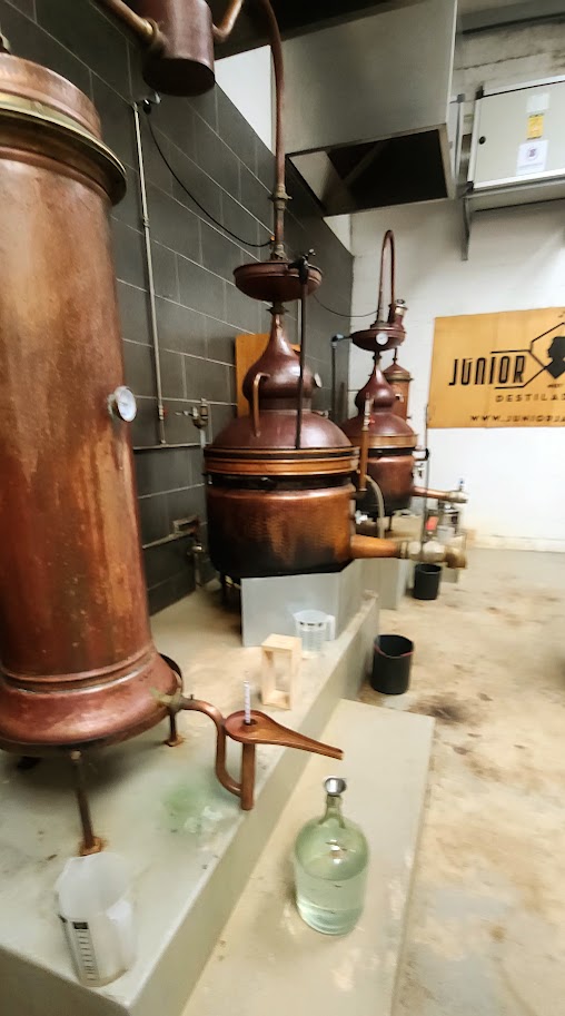
Our next surprise stop was at Junior Jaques Medronho Distillery, where one of the owners, Alfonso, passionately shared the story behind their journey to honor a cultural pastime and involve the local community in its revival. At the heart of it all is medronho, the fruit of the wild medronho tree.
Smoother than vodka, richer than whiskey with a fruity kick that leaves gin in the dust, it’s a flavor that tells a story. For centuries, locals in this region have handpicked medronho berries, using them in everything from homemade recipes to secret family distillations. Now, thanks to Alfonso and his team, that age-old tradition is being shared with the world, one handpicked berry and one sip at a time.
Of course, the experience couldn’t be considered complete without a tasting—there were a few varieties to sample. We politely sipped the tantalizing, heady spirits—it was 2PM, we’d long since burned off our breakfast buffet, and we still had a couple of miles to ride before lunch.
From the distillery, we rode back down the gravel road, crossed a short bridge, and followed a narrow, surprisingly busy, paved road into the picturesque village of Oxienta, nestled between the sea and the River Seixe.
At this point, we were all a bit overeager for lunch. The hollowness of our bellies had been punctuated by the intensity of the medronho spirits.
Along the road into the village was an amazing, vibrant, dynamic 260-foot mural. The group rode on, but I had to stop to marvel and capture pictures, only fragments, which don’t do justice to the splendor, scale, energy, or impact of this magnificent work of art.
A serene, beautiful native woman framed by hibiscus (mother nature?), and two birds anchors the far left of the mural, blue and red foxes spring into the air over mushrooms on either side of a hybrid fox man holding a rooster, a sea bird feeds her young, and at the other end a white-bearded, wool- capped fisherman amidst colorful fish and birds in flight (didn’t capture that section). See the entire span of the mural and learn about the artist, OZEARV, and his work here and on IG as OzeArv.
Commissioned by the Odeceixe Parish Board, Lisbon-born artist OZEARV, describes his work, “110 Steps to the Sea” on IG as follows: “[…]a reflection on the natural landscape and the socio-cultural fabric of the territory. I intended to celebrate the biodiversity[…]A painting that accompanies the River Seixe in which I tried to convey the feelings inherent to the transition from the past to modernity, reflecting the customs and traditions of the village that marks the border between Alentejo and the Algarve and what I consider to be a meeting place, inclusion and respect for nature. [Also, from the first to the last step, this is a mural that reflects on the journey of life, even if you are a human or any other animal, it’s part of life to take that walk from birth till death.
I would humbly ask the Odeceixe Parish Board to consider creating a walking and cycling path across from the mural so you can appreciate the artwork at your own pace without concern for traffic. After hastily snapping my pics of the mural, I joined the others for lunch in the delightful village square.
I devoured a fresh poke bowl.
After lunch, came a bit of unintended excitement.
We kicked off the final stretch of the day toward our overnight stop in Aljezur—riding along a fast, smooth, scenic section that hugged the river and ended with a punchy little climb that came out of nowhere. The group was riding faster than they had yet. (Yes, all but 3 of us were on ebikes, but despite being on ebikes, their pace had been surprisingly slow previously. You’ll understand why this is relevant in a moment.)
Just as we were gearing up for that ascent, I noticed something strange: no sign of Bradley. Usually, at the front of the pack with his clip-in bike shoes and steady pace, he was MIA. I turned around and sprinted back, calling out and checking with everyone I passed. Even our trusty volunteer “sweeper” gave me a clueless “nope” (though I’m pretty sure he mentally handed in his sweeper duties right then and there). Where’s Bradley?
So, off I went again—sprinting back up now to catch our fearless leader, Telmo, who was already powering up that hill. I shouted, but the wind swallowed the sound. It took some serious effort, but I finally caught up with him, and between gasps for air, I explained the situation. Cool and collected as ever, Telmo gathered the group in a scenic pullout to wait, then turned back and took off like a hero on a rescue mission.
With no cell service, it felt a bit hectic for a minute… until, moments later, who rolls up in the van with Pedro but Bradley, grinning sheepishly. Turns out he was head down strapping on his bike shoes when we disappeared into the cobblestone mini maze, all of us assuming he was right behind us. Luckily, he saw Pedro, our ever-reliable driver, and the van just around the corner. In the end, Telmo and I got some bonus cardio, and Bradley has a story to tell about that time he was “almost stranded” on a bike tour in Portugal.
After that hill I mentioned, the scenic, winding road continued to climb steadily for a few miles. Then suddenly, we were flying, soaring downhill for miles on a world-class descent straight into Aljezur. I do believe it was the longest downhill I’ve ever ridden. So smooth and fast that you forget every uphill pedal stroke that came before it. (Would certainly make for an “interesting” ascent.)
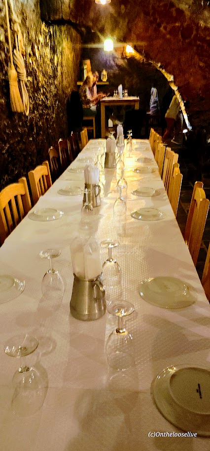
Whoohoo, what a day! We had just enough time to check in, freshen up, and swap out our bike outfits for something civilian. As the sun dipped low, we wandered over to the restaurant.
The restaurant was quite unassuming from the outside. Our host greeted us with a knowing smile and led us through a discreet side entrance. We ducked under the low stone arch entrance and stepped down into a hidden underground cavern with a private dining area for our group—it felt like we were guests in a medieval castle. Yet another unexpected and enchanting twist to end the day.
While the details of this meal are a bit fuzzy (we were all a bit wiped out from our full day at that point), I do recall the stroll back to the hotel in the magical moonlight.
Speaking of castles, little did we know then that the next morning’s first stop after a brutally steep cobblestone climb would be the ruins of an old fortress. Stay tuned for Biking Day 4 with Top Bike Tours Portugal.
Happy Adventures on Foot or Wheels! Loving Portugal! Can you tell?
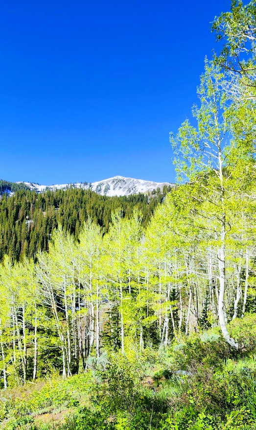
Difficulty: Easy +, depending on your fitness level and altitude acclimation
Elevation: 9,174 – 9,519 FT
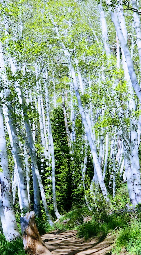
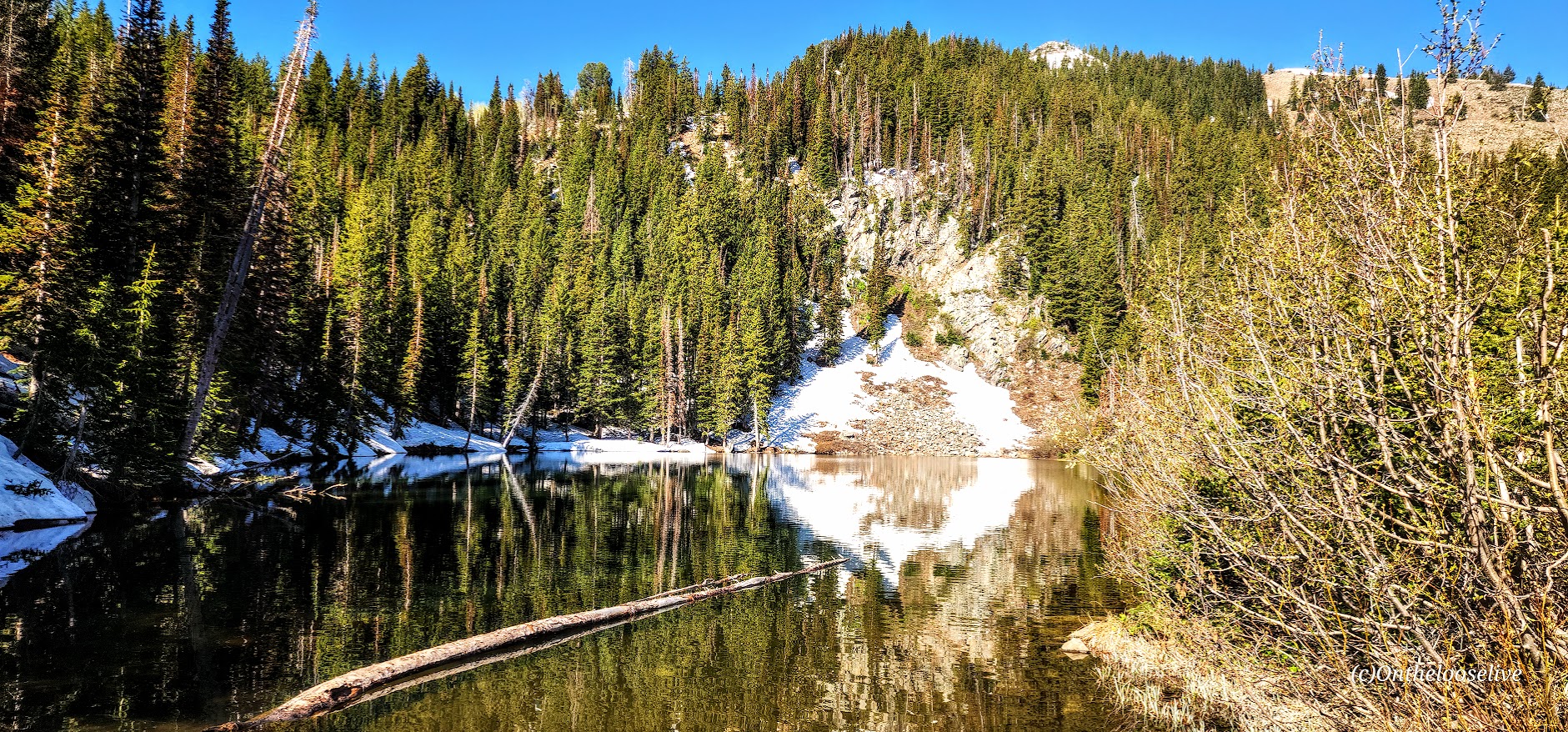
Named after the Bloods family, a pioneering family who homesteaded the area (not for what’s circulating in your veins or the lake color), the Bloods Lake trail is a short, pleasant stroll through the woods with a gradual incline on the smooth terrain of a well-groomed trail (trail runnable).
I wanted to make this shortie longer, but there was far too much snow beyond this lake. If you arrive after snow melt or have snowshoes, you can continue on to Lake Lackawaxen, named after its namesake river in Pennsylvania (2.6 miles, 1 way), Clayton Peak (2.7 miles, 1k FT elevation gain, 1 way), and Peak 10420 (2.5 miles, 1 way). Even if you hit them all, you won’t be able to get much mileage here.
This area is part of the Bonanza Flat Conservation Area, which was saved from development in 2017 thanks to a collaborative effort of various organizations and individuals. While that is indeed something to celebrate, they are recouping their costs aggressively, presumably to “manage increasing use, reduce congestion, and protect the area”. This is the most expensive trailhead parking scheme I have EVER encountered. They charge by the hour! It’s $5 per hour on weekdays and $8 per hour on weekends. Apparently, those who are privileged enough to live in the 84060 Park City zip code can apply for a free parking permit.
I paid $16 in advance, hoping I would make it to Clayton Peak and back. Deep snow stopped me at Bloods Lake, so I finished my hike within an hour with no recourse for a refund. Was it worth $8, yes – $16, no. As you can tell, I find this fee system utterly obnoxious. Though the silver lining is that it does motivate you to keep a fast pace, which I like- lol.
Getting there: The trailhead is one of several hiking trails along the super scenic Guardsman Pass.
Notes: Parking fills early on the weekends! Exorbitant hourly parking fees ($5 per hour on weekdays and $8 per hour on weekends)!