Kyoto is surrounded by mountains on three sides so the opportunities to hike abound. I haven’t been able to locate my trail notes on this one so I’m just going to post some photos from my Kyoto walkabout for now.
Sometimes your future
is clear and inviting. The
bridge appears; you cross.
Hmm…
Sometimes it’s hard to
know which way to go so let
the forest guide you.
Magical dappled light – must be the enlightened path
Find yourself in the
dazzling, dappled light-your path
to enlightenment.
Hidden shrines
Traditional buildings and cherry blossomsTemples
Never too far from civilizationSome signs are more helpful than others…Trail markers like this one at key intersections between Kyoto suburbia & Kyoto Forest trails were very helpful.
Cowles Mountain (1,593-foot summit) is the highest point in the city of San Diego. It’s part of Mission Trails Regional Park, a 5,800-acre open space preserve that is the 7th-largest open space urban park in the United States. It contains sixty miles of hiking, mountain bike and equestrian trails.
To call Cowles a mountain is to be very liberal with the word. I should note that the park has a 5 “peak” challenge if your hiking peeps want a minor challenge and want to document your feats – here’s the scoop. Cowles is the highest peak. This might be fun for kids, but apparently lots of adults do it for bragging rights too. I will say that on a clear day, the stunning views span 360 degrees from Lake Murray, downtown San Diego, Point Loma, La Jolla, and Mexico and out across the glimmering Pacific to the San Carlos Islands. See feature picture above. (Unfortunately, I dropped my camera on a rock so I have limited pics.)
Distance: 2.9 miles up & back
It’s a very popular trail so expect lots of humans and their canines…There are a couple of different ways to reach the top from various starting points and parking lots. The hike itself is moderate (with some steeper sections that will get those calves & glutes burning). It’s decent workout, especially if you run it. There are single track trails and some fire road. It’s short from any direction so I explored up and down on a couple of trails and was a little disappointed that there wasn’t more to see. You can’t really get lost so do as much or as little as you like.
Getting there:
The main trailhead is in the San Carlos neighborhood on the corner of Golfcrest Drive and Navajo Road
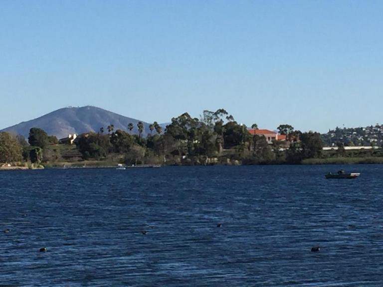
Lovely Lake Murray
Since I didn’t quite get enough enough of a workout / nature fix, I decided to check out alluring Lake Murray Reservoir, also part of the Mission Trails Regional Park. I strolled the paved road that navigates around most of the lake stopping short of the dam (no access). It’s another popular spot – walkers, runners, bladders, and even road bikers aplenty (the latter seems silly to me, because the path / road is only 3.2 mi long and there are many children and dogs on it).
Lake Murray is a great spot for birdwatchers with abundant ducks, geese, and herons abound and about 149 bird species to observe. It’s a pleasant spot for a picnic too.
Go Fish
Lake Murray is open for shore fishing and private boats, kayaks, and float tubes seven days a week from 5:30 a.m. to 8:00 p.m. Permits can be purchased onsite at the iron ranger boxes. The lake is stocked with Florida-strain largemouth bass, bluegill, channel catfish, black crappie, and trout. Minimum size limit for bass is 12 inches.
Fish limits: 5 trout, 5 bass (min. 12 inches), 5 catfish, 25 crappie and bluegill total, no other species limits
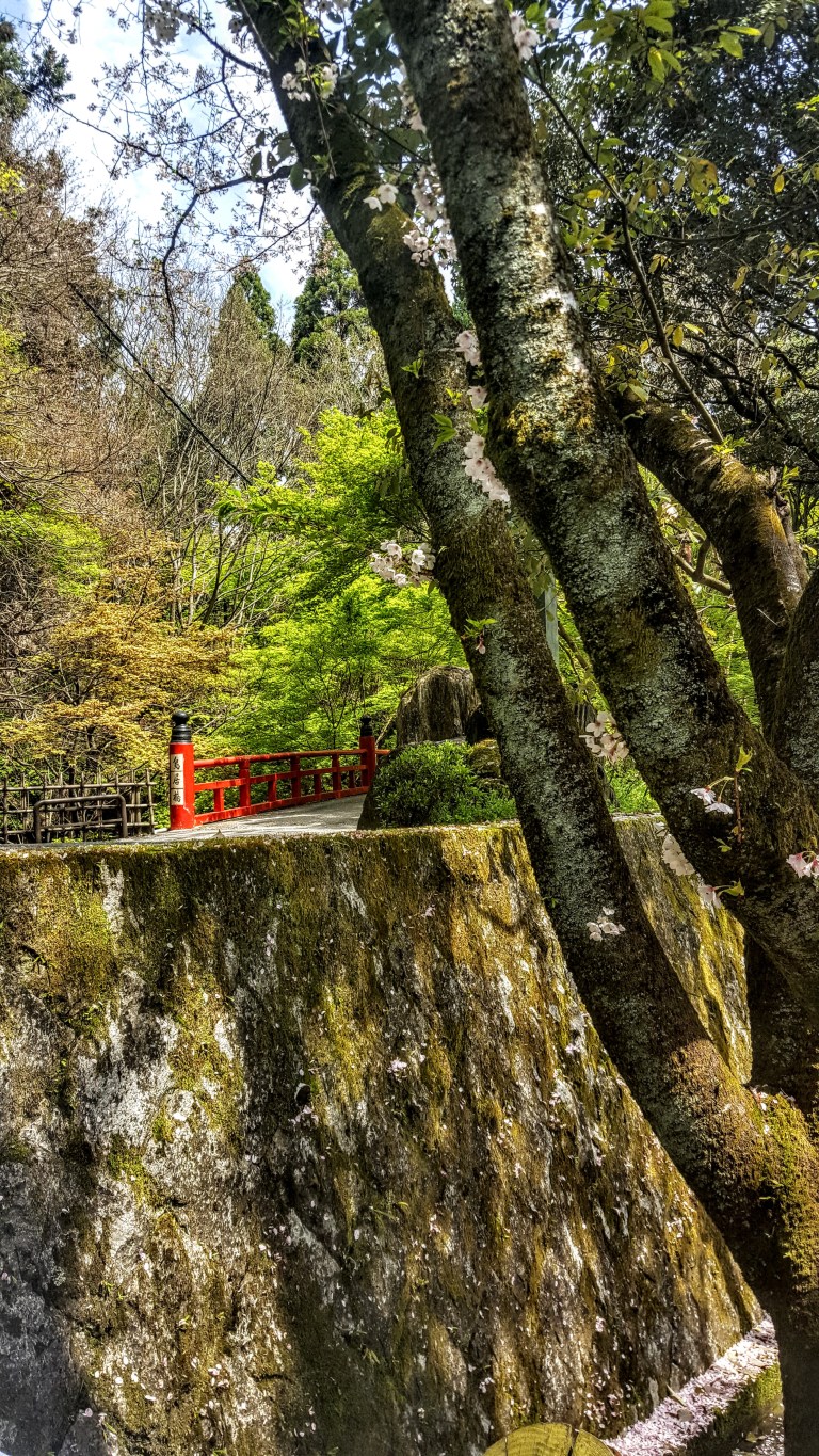
I’ve always been captivated by the idea of hiking from village to village – anywhere. When I was researching things to do near Kyoto before my trip, I learned of the short hike from Kibune village to Kurama village and decided it was a must do.
It was so much of a “must do” squeezed into my tight itinerary that I went ahead with my plans despite the downpour that day. Who knows when, if ever, I’ll return to Japan. (I was prepared with rain gear and warm clothes and no doubt the conditions would make the reward of the soaking in the Kurama Onsen even more decadent – it did.) Perhaps the title of this post should be : “Hike, get soaked and then soak.”
It didn’t take me long to explore the quaint, tiny hamlet of Kibune. In the heavy rain, few people were out and all the buildings seemed sealed tight against the elements. The only exception was the Kibune-jinja Shrine on the left hillside near the road.
I believe a wedding was taking place…
Apparently there are some amazing restaurants in Kibune with open dining platforms that extend over the rushing river below. Sadly, not today. After I checked the shrine out, I walked down steps, crossed the street, and walked over the river on the vermilion bridge to the trail head.
After paying the ~$3 entrance fee to the attendant in the little gate house and being warned of treacherous, muddy trail conditions, I cinched up my rain jacket hood and set out. (The attendant did not stop me or tell me that the trail was closed so I figured it would just be a muddy, slippery slog that would make me appreciate the onsen at the end even more – it did.) The hike is a mere 3.9km / 2.4 miles, but the mud and slippery conditions made what would have been a 40 min walk, much longer. It’s single track through the forest with Shinto shrines to discover along the way. You’ll know you’ve reached Kurama when you encounter picturesque Kurama dera, Buddhist temple.
Kurama dera, Buddhist Temple
Unfortunately, I have no pictures on the trail as it was raining so hard, I didn’t dare take my camera out. At the trails end, you have just 1 kilometer to go to reach Kurama Onsen.
At the Onsen, you have the option of soaking in an indoor spa or outdoor pool. I’m sure you can guess which one I chose. (For scoop on Onsen etiquette, see my previous post on the Fukuzumiro Ryokan.)
I soaked in the serene, lush mountain scenery, listening to the pitter patter of the rain drops on the leaves, watching the mist rise from the hot pool as the cool rain kissed my face and shoulders. I was transported to a different time, a different place, a different life. (Calgon eat your heart out.) And no, I don’t have pictures of this incredible setting – no cameras allowed for obvious reasons, but there are a couple of pictures on TripAdvisor…
Reluctantly leaving this scene behind, I enjoyed a sumptuous feast at the inn’s restaurant before returning by train to Kyoto.
Delightful Tempura Appetizers
Notes: You can hike the trail in either direction, but Kurama is a preferable end destination because it has more restaurants and is home to the Kurama Ryokan (traditional Japanese Inn) and Onsen (hot spring/ bath house). Apparently, this is the easier direction as well. Highly recommend this as a half day , full day or over-nighter out of Kyoto.
I imagine these villages are even more scenic in the fall with the red maple leaves and in the summer, when everything is green and glimmering.
Festivals:
On October 22, Kurama has a Fire Festival is that involves men and children carrying torches. It is a rite of passage for the town’s youth. I’ve read this is so overrun with tourist now that it’s difficult to see anything due to crowds.
Held in November at various Inari shrines on different days, including Kibune, the Ohitaki rice harvest festival is a thanksgiving event.
Distance: Relatively easy 3.9km / 2.4 miles – not quite as easy when muddy & slippery.
Getting there: It’s just a 30 minute train ride to Kibune via the Eizan Electric Railway from Demachiyanagi Station in northeastern Kyoto (each ~$4 one way). You can catch the Eizan Electric Railway train back in Kurama.
Top Pick: While I didn’t stay overnight at Kurama Ryokan, I can speak to my Onsen and restaurant experience, both of which were superb.
In many ways, Torrey Pines State Natural Reserve Extension, the quiet younger park outshines her excessively popular, bigger sister. Especially if you like your nature served up with a bit of solitude as I do mine. This area was acquired in 1970, 11 years after Torrey Pines itself became an official State Park thanks to the work of local conservation groups.
The pros: You still get stellar (though more distant) views of the glimmering Pacific and bedazzling Penasquitos Lagoon (if it’s a clear day) and close-ups of the dramatic red, other-worldy, sculpted, sandstones cliffs and Torrey Pines. Some of the trails are boarding rows of McMansions so you don’t quite escape from suburbia unless you put your blinders on.
The cons: There trails are really short and easy on sandstone or sandy terrain. (Could be considered a pro for some, I know.) Apparently there’s some way to eek out 4 miles, not sure how. You’ll be hard-pressed to get in a workout here – unless you run them quickly. Also, there is no beach access.
When I went there were no trail maps in the box so I just meandered through the network of short trails. You can’t really get lost. If you’re going, you may want to check out the online map first.
To share a “secret” locale or not, that is the question.
I’ve lived in the Sand Diego area for about a decade and had never heard of this area. This spot is relatively quiet and underutilized. Yes, it’s nice to keep it that way so am I betraying it by writing this post? Well, this is part of a State Park, which means it is open to the public and shouldn’t be a secret. So on one hand, I believe it’s appropriate to share the information. And I believe, perhaps naively, that people who love this sort of place will respect it and tread lightly. On the other hand, I’d hate to see it get overrun. (Much controversy surrounds the instagram and social sharing phenomenon.) Then again, since this place is part of a State Park, I imagine that park officials would intervene as necessary should the area become compromised due to excessive use. Tell me, what’s your opinion of sharing vs. keeping your favorite spots secret?
Warning soapbox
It seems strange that the signs and literature at Torrey Pines State Park don’t make any reference to this area. It almost feels like the Del Mar locals (who may include some of the original conservationists) have played a role in keeping this on down low. Ok, am I approaching conspiracy theory level yet? (I’m just saying it seems awfully convenient that they have managed to keep the trail and the views all to themselves and their dogs.) Dogs, you say? Are they allowed? No, they aren’t and there are “No Dogs” signs posted everywhere. Yet, of the half dozen or so people we ran into, most had their 4-legged companions with them. Not only that, when we started out on the trail a Golden Retriever bounded down from the one of the homes and raced in front of us, eager to guide us through “his park”. Hey, I’m a dog lover, but there’s a reason they’ve posted no dog signs everywhere, right? Fragile ecosystem, etc…I guess if you live in Del Mar, the rules don’t apply to you. Ok, maybe not all the hikers with dogs were from Del Mar, but chances are…
Getting there: From I-5, take the Del Mar Heights Road exit. Head west on Del Mar Heights Road for approximately half a mile. Turn left onto Mercado Drive, then left onto Cordero Road. Make a right onto Mira Montana Drive and follow it to the end where you’ll find a couple parking spots and a trail head next to Del Mar Heights Elementary School. Parking and entry is free. There are other access points in the neighborhood with ample parking along the street.
Notes
No Dogs (Even though plenty of entitled peeps and pooches were violating this rule.)
A few people have asked me what I’d recommend for a couples’ 2 to 3 night camping trip in Catalina. For nature lover’s with limited time, I suggest you skip touristy (though charming) Avalon and head straight for Catalina’s “Wildland” gems. Most Catalina aficionados concur that the 2 most beautiful spots on the island (not that you can really go wrong anywhere) are Little Harbor Campground and Parson’s Landing Campground. I’ll focus this post on them.
If you like this sort of thing, you’ll love those 2 spots.
Contemplating the climb ahead from Little Harbor Cove
Leaving Lovely Little Harbor
Heading down to picturesque Parson’s Landing
MAP
How you plan your getaway comes down to your preferred balance of activity to relaxation.
If you want to see both Little Harbor and Parson’s Landing, the easiest way to do it is to take the San Pedro ferry direct to Two Harbors. Once there, you are equidistant to Parson’s Landing and Little Harbor – this gives you the most flexibility and the most relaxation and recreation options. You can grab a bite and set out for either destination as a day hike / bike or an overnight at one or both of them. You can also catch a shuttle one or both ways.
When you visit Two Harbors, enjoy a meal at Doug’s Harbor Sands – the only restaurant / bar in town. I recommend the Mahe and a Buffalo Milk or two for dessert. Buffalo Milk is a delicious libation named after the island’s iconic buffalo (think alcoholic chocolate milkshake). I’d post a picture of one, but I drank them so fast I forgot to take one.
Otherwise, you could stay over in Little Harbor night 1 and then work your way West to Two Harbors and Parson’s Landing. On a quickie? Perhaps you take the Safari Bus back to Two Harbors or Avalon. (Arrange in advance.)
Staying Overnight in Two Harbors
Two Harbors Campground (42 tent sites & 3 Group sites) about a 1/4 from “town” on a bluff overlooking the Pacific. Outdoor cold water showers & portapotties.
In “town”, the Camping Cabins offer simple comforts on a budget ($50-70 a night) They are available November through March only.
Note: There are coin operated hot water showers in Two Harbors.
After roughing it for a day or two, I always like to throw in a little luxury. See why the rustic Banning House Lodge in Two Harbors is myTop Pick .
Two Harbors Things to Do: Diving, snorkeling, swimming, stand-up-paddling, kayaking, fishing, exploring and relaxing. So yes, you can have tons of fun just hanging in gorgeous Two Harbors. Did I mention the Buffalo Milk? (Yeah, I did.)
Head from Two Harbors to Parson’s Landing (via West End Road – easy fire road ~7 miles & or the Trans Catalina Trail – hard single track ~11 miles) and camp out there. Note there is no running water at this campsite. You can hike from here to Starlight Beach (the Western most point of the island), but be prepared for 20 miles round trip as Starlight Beach is day use only.
Avalon to Two Harbors ~23 miles (MTB route – ~3,284 elevation gain)
Little Harbor to Two Harbors ~7 miles by fire road or shorter by single track, expect a fair amount of climbing in either direction
Two Harbors to Parson’s Landing ~7 easy miles West End Road or ~11 via a challenging portion of the Trans Catalina Trail (hikers only) Note: Parson’s Landing Campgraound has no running water.
Two Harbors to Starlight Beach ~17 to ~21 miles depending on your route (see above)
Catch the Catalina Express from San Pedro to go direct to Two Harbors ~$75 ea round trip.
Or treat yourself to a Helicopter ride, starting at ~$135 one way depending upon your departure point. It’s a quick way to spend $135, but it is a dazzling ~15+ minutes. (One way is enough, unless you’re in a hurry and have $ to burn.)
If you have a boat, you’ve got it made to explore your way.
If you start in Avalon, you can take the island’s Safari Bus to Little Harbor, Two Harbors, or Parson’s Landing, but you are limited by their schedule. Mountain biking or hiking is possible too, but only if you’re up for ~23 somewhat tortuous miles (especially if you’re going to be carrying a pack) see my Catalina mtb. adventure post 1 & 3). There is a new Catalina Back Country Concierge that offers gear haul and other services, but they may not be open on weekdays in the off season – – at least they weren’t when we called them.
Another option is to stay in Little Harbor the first night and save the final 7 miles to Two Harbors for Day 2…
So many fantastic options, so little time. Be safe and have a blast!
I’ve been all over the island, the terrain can be challenging and most of it is completely exposed. (Carry plenty of water and sunscreen.) Keep ~150 yards from Buffalo. (They don’t like bikers.) Stay on designated trails and fire roads. Taking that short cut through brush may be tempting, but my brother will tell you, it’s not worth it. He got bitten by a rattlesnake there doing just that and had to be airlifted off the island. He’s fine now, but it was a bit sketchy during his two weeks in ICU…And no, I wasn’t on that trip.
Let me know if you have questions and do tell me what you did on your Catalina getaway!