Dazzling Panoramic Scenery: Dante’s View to Mt. Perry Hike plus Badwater Basin Bonus!

Distance: ~8 Miles

Elevation Gain: ~2,346ft

Difficulty: Strenuous to moderate, depending on your fitness level. Trail runnable until you reach the top scree and talus portion.

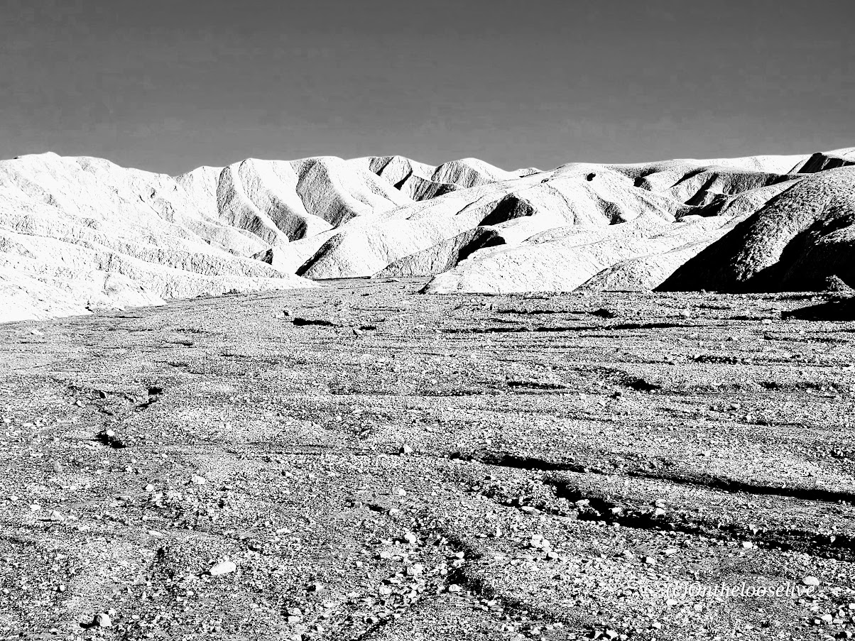
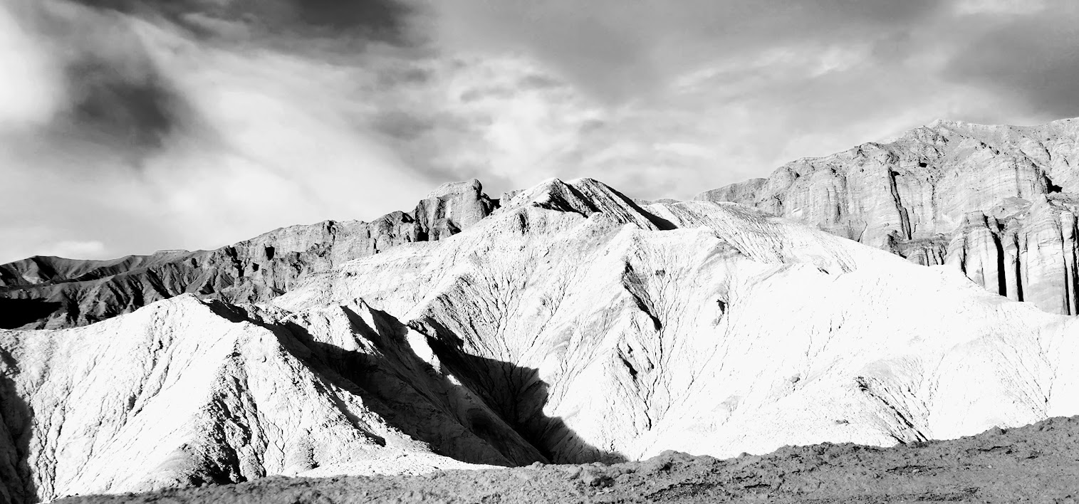
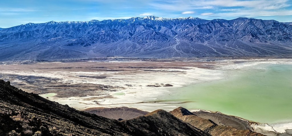
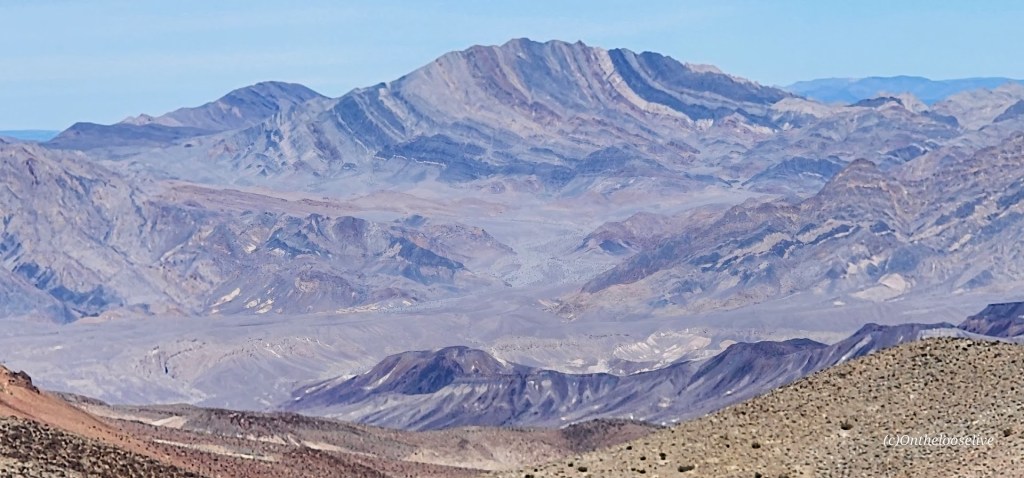
The unofficial trail begins at the north end of the Dantes View parking lot. The unmarked single-track rim trail climbs and descends different ridges eventually leading to the peak of Mt. Perry (5,378 ft). The vast views in every direction are enchanting—across the valley to snow-capped Telescope Peak and down to the mesmerizing turquoise, emerald waters of Badwater Basin below.

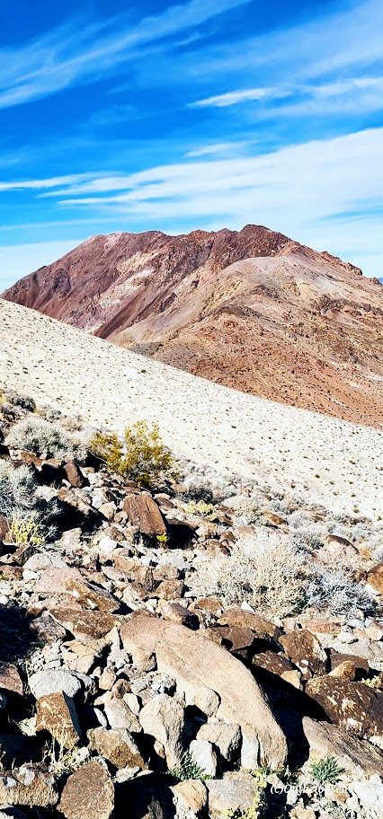
Towards the peak, the loose scree and talus field get gnarly and may require a “4 on the floor”(hands and feet) approach. There’s no shame in stopping short if the rugged terrain becomes too disagreeable—the view is spectacular all along the way and at any of 3 false summits.

If you don’t have time to hike, Dante’s View is worth the drive up, especially at sunrise or sunset.

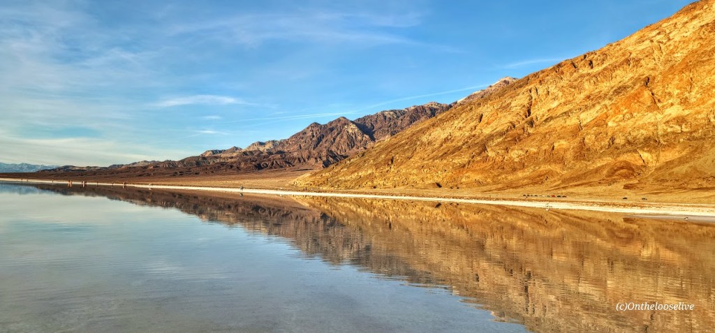
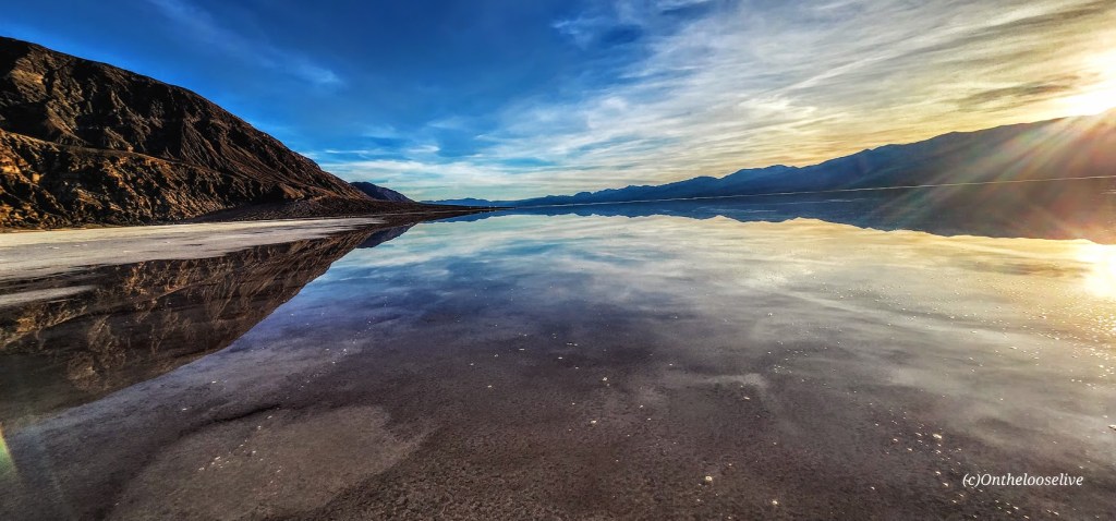
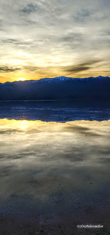
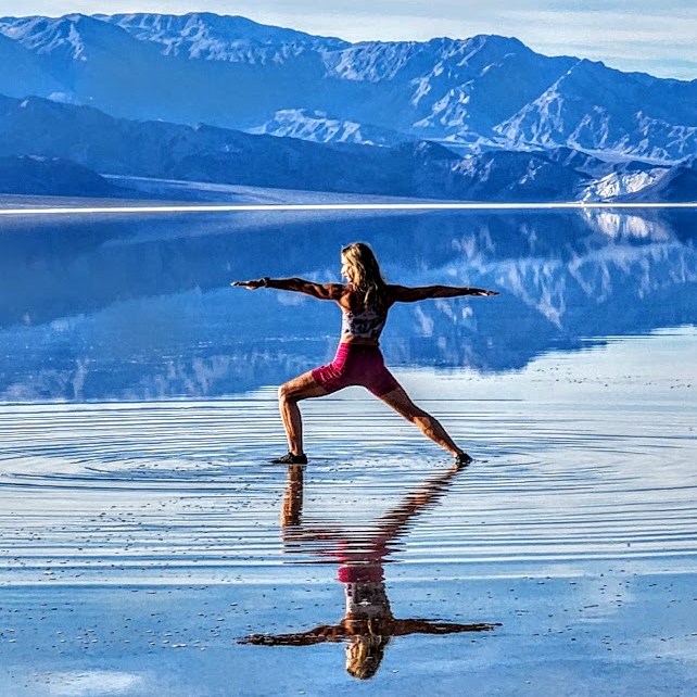
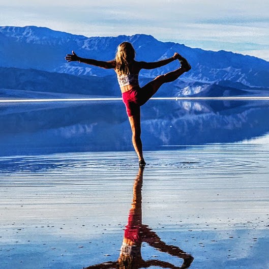
A once-in-a-lifetime opportunity to see Lake Manly/ Badwater Basin with water!

Whether you drive by it or up to Dante’s for the bird’s eye view, you must visit Badwater Basin, especially now! The lowest point in North America and the United States, Badwater Basin, an expansive salt flat, is the remnant of a vast and deep (600 ft deep) ancient lake that existed tens of thousands of years ago. During the past six months, thanks to the recent record-setting “atmospheric rivers,” the ancient  “lake” has resurfaced into a 6-mile by 3-mile shallow (1 ft deep) “lake”. With warmer temperatures around the corner, the lake will evaporate before long, leaving only the vast, barren salt flat. For those lucky enough to see Lake Manly with water, that ephemeral glimmering experience will remain imprinted like a mirage flickering in our memories (and captured in our photos).

Happy Trails!

Couldn’t resist the once-in-a-lifetime yogi pose reflection photoshoot at Badwater!

Getting there: Dante’s View is a ~45-minute drive from Furnace Creek. Take the main Highway 190 route SE for 11 miles. Pass Zabriskie’s Point and turn right on Dante’s View Road (13 miles). Badwater Basin is a 17-mile drive from Furnace Creek via the 190, turn right on Badwater Basin Road.

Hike smart: Dante’s View to Mt. Perry is completely exposed. Summer hiking after 10AM is not recommended.

Zooming around the Zabriskie Point Loop, Death Valley National Park

Miles: ~7, options for additional explorations along the way in Gower Gulch, Gold Canyon, and Red Cathedral. You can also take the shorter, easier Badlands Loop (2.5 miles) for a quick immersion. If you’re not up for a hike, you can take the ¼ mile walk up a hill on a paved path to the lookout.

Elevation gain: 827 ft

Difficulty: Easy to moderate, depending on your fitness level. The trail is “runnable” when crowds are light.

Rated # 3 top hike in Death Valley National Park.

Among the most photographed spots in Death Valley National Park, Zabriskie Point boasts expansive views of yellow and brown striped hills, the badlands and salt flats beyond, and the Eastern Sierras in the far distance. Great for sunrise and sunset pics! I got there just before sunset so made it a fast zoom around. I’ve explored Golden Gulch before that’s worth it too!

The dance of light and shadow on the stark dramatic landscape is compelling in color and black and white. It’s obvious why this area was one of Ansel Adam’s favorite photography playgrounds.

If you look closely at the picture on the right above, you can see the trail tracing its way up to the ridge.

Fun Fact: Death Valley is the hottest place on earth and the lowest, driest place in North America.

Getting there: The Zabriskie Point lookout and trailhead parking lot for both Badlands and the Zabriskie loop is a 15-minute drive East on Highway 190 from Furnace Creek Visitor Center.

Happy Trails!

A Tale of 2 Lolos From Catalina Island

Meet Lolo and his falconer, Dave Long, the founder of the Catalina Falconry Experience.
I met Dave and Lolo, the Harris hawk, on the beach while enjoying happy hour at a local establishment. Dave was nice enough to come by and tell my friend and me what he and Lolo were up to. He said Lolo is a working bird. His job is to keep the seagulls from camping out around the beach, restaurants, and shops of Avalon. The restaurants on the shore draw both tourists and seagulls in large numbers. When left to their own devices, seagulls will camp out and wait for crumbs and handouts. An excessive amount of seagulls in the area means an excessive amount of seagull poop in the water, which leads to excessive bacteria counts and that stinks for all. I always wondered why the bacteria levels were so high in what looks like crystal clear turquoise waters of Catalina. Now I know.
Lolo the hawk was named after Lolo Saldana, the legendary local barber of Avalon. Lolo’s father came to Catalina in 1919, the same year that William Wrigley, Jr. purchased the island. Born and raised in Catalina, Lolo is 94 years old and still tending shop and cutting hair in his barber shop as he has for last half-century. Watch the documentary about Lolo the barber on YouTube.
If you’d like to see what it feels like to have this majestic Southwestern hawk or other raptors land on your hand and learn about them, check out the Catalina Falconry Experience next time you’re on the island. And if you need a haircut, stop into the barbershop and get your hair cut by a legend.
https://www.visitcatalinaisland.com/things-to-do/land-tours/falconry-experience/
https://www.facebook.com/catalinafalconryexperience/

(800) 626-1496

The Social Distancing Antidote: Nature Immersion

Solace in nature, always. At least that’s what I’ve always said. And yes, you can say I’m an outlier as social distancing is my default mode anyway. However, I’ve always maintained that our lack of connection with nature and our physical selves is at the root of so many of our 21st century ailments—physical and emotional. We are wired to spend 8+ hours a day being active, outdoors and I believe that is the key to really thriving.

Of course, for most of us, that’s not practical. But certainly, squeezing in some form of outdoor activity every day is. Probably, if you’re reading this, it’s because you’re like-minded and already reap the benefits of outdoor activities. It’s our indoor, sedentary neighbors we need to convert.  Perhaps, the silver lining of social distancing is that people will get stir crazy enough to venture outside and explore their corner of the natural world.  #optoutside

Here are some pictures from yesterday’s suburban hike in San Marcos. What a pleasant surprise to find a little network of trails right behind Palomar College. You can take a steep, direct approach to the “P”, or opt for the more, roundabout, meandering one. (You can probably guess, which one I took.)

up

Once at the top, you can trace your way across the ridges as long as your heart desires.

P

Either way, you’ll be rewarded with lovely views of the surrounding mountains and out to the Pacific.  The air was so fragrant and clean. The red dirt and delicious post-rain scents reminded me of hiking in Hawaii.

flora

Pacific Views From the P

Apparently, this area is popular with the off-roaders as evidenced by the debris. It appears many of them have lost control—careening and crashing through the rocks and scrub.

truck

The social distance—just right for a suburban hike.

L on P Trail

Take the Road Less Traveled: Mountain Biking the High Point Truck Trail (FSR 8S05)

Bike up the backside of Palomar Mountain. Get a great workout while enjoying some solitude and splendid views of the San Diego back country, including Vail Lake and numerous snow-capped peaks (Thomas Mountain, San Jacinto, and San Gorgonio). This is nontechnical mountain biking at its best. If you like a climb with views, it’s a good one. Exceeded my expectations.

Road restrictions
Their loss, our advantage. 

L points to trail
When you can visualize a goal, you can attain it!

This slideshow requires JavaScript.

We turned around at mile 8 as the trail was getting muddy and we were running out of daylight. It’s worth coming back to finish it off. Will update this post when I do. Until then, let the good times roll! What a spectacular way to spend the first day of 2020!

L and Palomar

Miles: 12 Miles / 24 Miles Roundtrip

Elevation: ~4,000 ft

Difficulty: Depends on your fitness level, knee health, and affinity for climbs. Very doable, the super steep sections are relatively short. Terrain has some rutty sections, but mostly good. This would also be a great trail run, or training for the Catalina Marathon, or any endurance races.

Directions: From Temecula, take HWY 79 east for 18 miles. Stay on HWY 79 and make a right 2/10ths of a mile past the junction of HWY 371 to an RV park/resort. Follow the paved road for 0.3 miles then park in the large dirt area in front of the Fire Service Road 8S05

Notes: There’s no water along this exposed route—plan accordingly. It’s hot during the summer and you may encounter snow during winter, or mud after heavy rains or melts. Vehicles are allowed on this route, but seasonal closures for motorized access often occur. (A bonus for mountain bikers and trail runners.) Further up the mountain, the Forest Service has labeled the High Point Truck Trail (8S05) as 9S09 between this junction and the Palomar Divide Truck. When in doubt, stay on the most “main” looking route.

mtb dog
Celebrity MTB Canine Sighting

Bonus: Be sure to top off your ride with a visit to Ricardo Breceda’s amazing outdoor gallery of metal sculptures. Also, check out his work in wild open spaces of Anza Borrego too!