Enthralling Elephant Arch, Washington, UT

Distance:~3.5 miles

Difficulty: Easy with the following disclaimer: ~ 2 miles of THICK sand walking

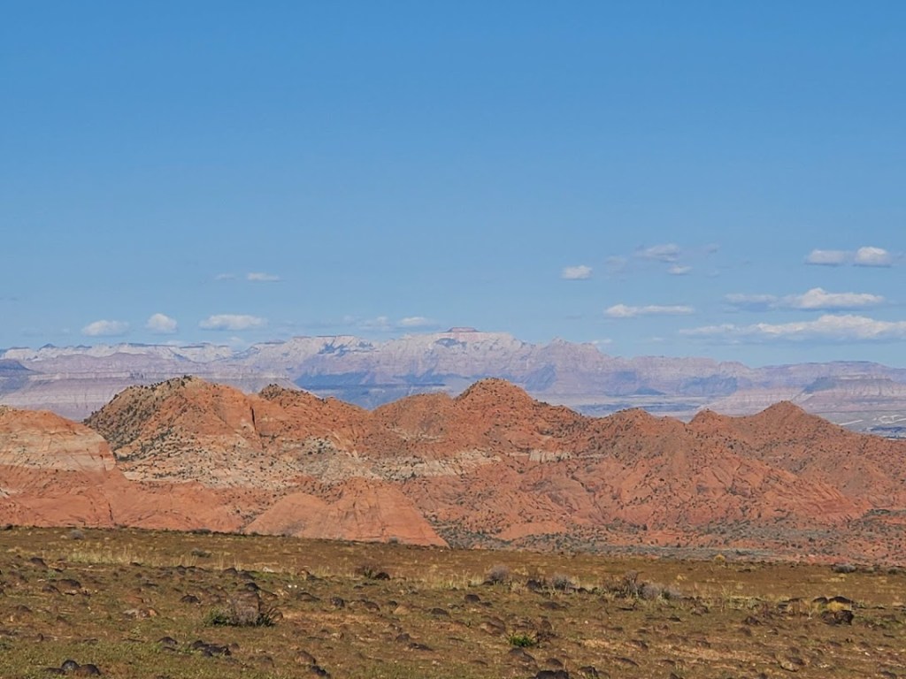
Part of the Red Cliffs Desert Reserve, this short hike delivers the reward of one of the coolest rock / arch formations that I’ve seen. (In my opinion, the Elephant rock in Valley of Fire doesn’t even compare.)  See it for yourself and let me know what you’ve seen that tops it.

Getting there: I-15N from St. George, Exit 10 to Washington. Left onto Green Springs Drive, immediate right onto Buena Vista Blvd. Follow. In about 1 mile, turn left onto the dirt road immediately after the fire station. Follow it for about 1.2 miles to the intersection of another dirt road and turn left onto this dirt road. In about a half mile you’ll see the parking area, gate and trailhead. (Directions are a bit tricky & terrain is variable–high clearance / 4-wheel drive vehicle helpful.) Took me 3x until I finally found it.

Trailhead GPS: 37.161671, -113.512897 Arch GPS: 37.177333, -113.494083

Notes: Full sun exposure, bring your water, hats, and sunscreen. (Spring, Fall & Winter are the best time of year for this one.) Leashed dogs allowed. Parking is free.

Happy trails!

Ice House Trail, Washington, UT

Distance: You decide, trail goes for 6+ miles out. (According to Alltrails, you can make it a 17.1mile loop, but that entails at least 5 miles of bland fire road, whereas an out and back avoids the fire road portion.)

Difficulty: Easy-+, depending on fitness level and length of your hike

Elevation gain:1,434

Highlights: Wildflowers, panoramic views, and some incline

The Ice House trail runs up the side of a mesa (Broken Mesa) with an initial elevation gain of about 600ft. The terrain for the first incline section is a bit technical with chunky and loose rock. Hats off to the mountain bikers who can make that section without walking, I’m sure that I couldn’t. (And not sure I’d want to hike-a-bike that first half mile or so – perhaps nontechies like me can do it in reverse and turn around here.) After that it’s a gradual incline up the mesa on a single-track trail that is ridable, runnable, or strollable. Enjoy panoramic views (Pine Mountain, Zion, etc.) and wildflowers if you hit it at the right time.

Great hike for spring flowers, sunset, and some solitude.

Pleasant, but not a “must do” in my book. Good trail for endurance runners and backpack training.)

The trail is so named because it was route pioneers use to take to bring ice down for food storage from a storage pit located at higher elevation in the Pine Valley Mountains.

Notes:100% exposed trail so recommend avoiding it in the summer and suggest you bring plenty of water, a hat, and sunscreen.Leashed dogs allowed.

Getting there: The trailhead is at the back edge of the Green Springs Terraces development in Washington between house 2255 and 886. You can also access the Mustang Pass trail (looks like it could be interesting) and the Middleton Powerlines trail (looks like you can get some mileage on a mountain bike, but not very interesting for bike or hike).

Washington’s Beacon Rock Trail: a shortie with sweet views

Geological origins

According to some experts, Beacon Rock or  Che-Che-op-tin, which means the navel of the world, is the second largest, free-standing monolith in North America.  (Supposedly approaching the ranks of El Capitan, Devils Tower, Uluru/Ayers Rock, and other notables.) Composed of Basalt, it is the core of an ancient volcano. Through the ages, massive floods carved their way through the Columbia River Gorge and through the volcano, leaving only the core of Beacon Rock in their wake.

The trail

The Beacon Rock Trail was built directly onto the side of the rock, and ascends to the top of the rock (850’ elevation) by way of 52 switchbacks. Along the way there are sparkling panoramic views of the Columbia River Gorge, the Bonneville Dam, and the Pierce Wildlife Refuge. The “peak” area is small and doesn’t offer much in the way of scenery. It’s a short and relatively easy ~1.6 mile out and back with a 680 foot elevation gain. There’s  a fair amount of traffic as it’s right off Highway 14, perfect for a quick run up and down. (Of course, I happened to hit it at high noon on Washington’s hottest day in a record-breaking heat wave. Dangerous for pets or anyone not up to extreme temps.)

The story behind the trail

The story goes that the United States Army Corps was going to cannibalize the rock for material to build a jetty at the mouth of the Columbia River. In 1915, philanthropist, Henry Biddle, bought the rock for $1, and together with Charles Johnson, built the trail over the next 3 years. After Biddle’s death, the family offered to make it a state park. Washington initially declined, but accepted the offer after Oregon expressed interest.


Details

Located near Stevenson, WA off of Highway 14

Discover Pass must be purchased and displayed in your car.


Spokane Quickie

First impressions: Fantastic fall foliage, clean, bike-friendly city, easy to navigate, nice parks, incredible vistas, great centennial trail, rainy.

Arrived at the small airport at noon, rented a car, and headed directly to Spoke ‘N Sport. Pete set us up on a couple hybrids for our quick tour of Spokane. Just a half hour after landing, we’re pedaling through Riverfront Park, meandering by Gonzaga University where the fall’s display was in its full glory.

20161029_132941

Despite the brisk, wet weather, there were many runners (one stud without a shirt), bikers, and skateboarders about. In addition to nature’s displays, the city also features many outdoor art sculptures.

20161029_145551
Monroe Street Bridge, built in 1911

A little history:

Built in 1911, the 896 foot Monroe Street Bridge spans the Spokane River, which flows at 7,946 cubic feet per second here. The Spokane River is a tributary of the Columbia River, approximately 111 miles long, in northern Idaho and eastern Washington. At one time, Spokane was internationally known for its fishing, including Chinook, steelhead and coho salmon and, above the falls, a huge population of cutthroat trout. Sadly, those days are long gone.The Little Falls Dam, built in 1911 had only had a rudimentary fish ladder and the Long Lake Dam built in 1915 didn’t have one at all. In 1939, the Grand Coulee Dam blocked the Columbia, which sealed the salmon off from the entire Spokane River and thus destroyed a dietary staple and way of life of the Spokane Indians and many other tribe’s.

20161029_141651
Another lovely view of the Spokane River from the Riverfront Park bike trail

We managed to get in some great views of Spokane Falls, Riverfront Park and cruise an upscale neighborhood on Summit Road before the rain became more insistent.

20161029_150623 (1)
Moose sighting along Spokane’s Riverfront Park Bike Trail

Very enjoyable afternoon spent in Spokane. Would like to return and explore some more and do the Centennial bike trail to Coeur d’alene and back.

Coeur d’alene was next on the agenda, but the overly-manicured waterfront park, upscale shops and restaurants didn’t appeal in the pouring rain. We kept driving and happened upon the charming gem of Sandpoint, Idaho, where we spent the night.