A designated national natural landmark and wilderness study area, Hell’s Half Acre Lava Field is a basaltic lava plain found in the desert ecosystem of the Snake River Plain of Idaho. It consists of about 150 sq miles of other-wordly terrain created by a lava flow from about 4,100 years ago. There’s a 1/2 mile trail marked by blue poles, you can follow those to the red poles that lead you out 4.5 miles to the central vent, where the lava broke through the surface thousands of years ago (9.4 mile round trip).
Hiking across a lava field is not for everyone, especially not for the tender footed. It’s cool, but the novelty wears off fast. While the trail is flat and easy, the terrain itself is tough and unforgiving. Lava rock is extremely sharp – like glass shards- and fragmented and the field is a trap of open cracks, gaping holes, jagged rocks and uneven, tortuous footing. It’s slow and treacherous going. One misstep can land your foot or your body in a hole. And if you trip, you’re likely to be broken, bruised or bleeding. Sneakers are not enough, the lava will eat them up. I’d recommend sturdy hiking shoes even for the short stroll. Also, it’s easy to get lost in the vast monotonous beauty of the lava field, you really have to look for those trail pole markers. Not a hike to set the kids loose on. Do not attempt the long hike in the summer as this place gets hot as hades.
Normally, I’m up for a hiking challenge, but I was happy to keep it short here, especially when I heard the rednecks firing shotguns close by…(sigh).
So I asked my athletic beau, Ken, “How about we take our mountain bikes to Catalina and ride from Avalon to Two Harbors, hang out and ride around there for a day, and then ride back? What do you think? ”
“Sure, sounds good,” he replied without blinking an eye…This is where I should have pulled out the disclaimers about the ~1700 foot climbs (that’s plural) that we’d be doing from sea level over the course of ~21 mile traverse across steep, unforgiving fire roads, and the fact that he’d be carrying a heavier pack than I…
I did dig out my old map of the marathon route with its epic elevation gains and losses, but he didn’t give it a glance. I declared with my usual exuberance, “It’s going to be a tough one, but it will be a great adventure!” You see, back in 2000, (yes, nearly two decades ago), I ran the Catalina Marathon, which takes you across some of the same routes so I had a distant, but visceral memory of how “challenging” the climbs on the island can be. (Decades of trail running has also taught me that’s it far easier to run up hills than it is to bike up them, especially if you are on heavy, beater bikes lugging packs on your back.) Of course, I’m nearly 2 decades older now and should also mention that we don’t mountain bike much (our last MTB adventure was Noble Canyon and we all know how that went. My bruises have finally faded,)
Bottom line, we both try to maintain a moderately-high fitness level for our weekend warrior and extended escapades and active adventures…(I’ve been focusing on yoga, swimming, hiking and a weekly road bike and he’s been running, and joining me for swims and road bikes as his schedule allows.) Unfortunately, I can’t run any more due to literally running out of cartilage in both my knees. Ugh, I know! For some reason, I thought I would be ok on the mountain bike with the hills…
About Catalina
Catalina Island is a small (22 miles long & 8 miles at its widest point) rocky gem in the Pacific ~ 22 miles from Los Angeles, but thanks to nearly 50 years of the Catalina Islands Conservancy’s good work, it’s really worlds away! The island’s topography is a study in rugged beauty with steep cliffs and jagged coastline. Ninety percent of the island’s 4k population live in Avalon, which is also the Island’s major tourist destination with quaint shops, restaurants and bars. Yes, it has its charm, but you know by now that I’m more of a “wildlands” fan myself. That’s why we’re heading to the remote Westside of the island and staying in Two Harbors,
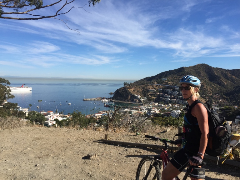
View point just after the initial climb out of Avalon on Stage Road – that’s the “What did I get us into this time?” look. Notice the over-packed backpack.
So I was wrong about that. Not long after the picture above was taken, 3/4 through the first climb from sea level up the airport road, I thought my knees were going to explode. No way I can make this, I thought. That’s when Ken pulled over and ordered me to empty everything heavy out of my pack and put it into his. I didn’t argue, toughing it out wasn’t an option if we were going to make it across. Yes, Ken is a stud and my hero! Wouldn’t have been able to make it without him taking on the extra poundage.
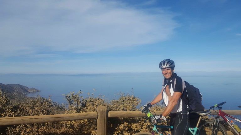
My hero, Ken, aka Superman, all smiles despite the extra weight in his pack. This is at the top of the first climb, he’s thinking the worst is over…I know we’ve only just begun.But views like these of the remote backside of Catalina can turn even my worst grimace into a smile…
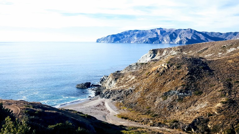
We left Avalon after 1PM and we didn’t pass the halfway mark until 3PM with all my knee breaks so we were getting a little worried that we might not make it by dark. There were no hikers or bikers out except for us and only a few cars and Island Conservancy trucks passed us. We had decided not to camp as we’d be carrying the weight of sleeping bags and Thermarests and possibly a tent too. Instead, we decided to treat ourselves to a stay at the Banning House Lodge for both our recent birthdays. So instead of stopping and relaxing at one of these gorgeous deserted beaches we pushed on and on…
We came around a corner and a gorgeous Catalina Fox crossed in front of Ken. Unfortunately, my camera was in my backpack and getting it out would have scared it away so we both just sat still and watched in quiet wonder as the beautiful creature took 5 steps looked back at us, took five more, looked back again, and once more before disappearing into the roadside brush. As if to say, “Hey, I’m giving you guys plenty of photo ops, what’s your problem?” This would be the first of several fox sightings in which I would be camera cursed each time. (Luckily, we met a great couple from Carlsbad (John & Julie) who caught some great pics while we were having dinner together at Harbor Sands. Stay tuned.)
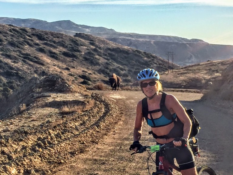
We would have one more notably larger critter encounter on our final climb out of Little Harbor, a brute of a buffalo was snorting and drooling his way up the hill. He was on the far right. We stayed as far left as we could.
Buffalo can charge at 35 mph and jump 6 feet high. And, we were told later, not unlike other aggressors, they have a thing for bikers. Yes, yikes. That’s my “Forget the picture and let’s keep moving.” look.
About Catalina’s Wild Buffalo
In 1924, 14 buffalo were brought to the island for a movie shoot and the rest, they say, is history. The bison thrived here and at one point the herd grew to 600. Today, the Catalina Island Conservancy manages the population (via birth control) to about 150, thereby striking the balance between protecting the sensitive ecosystem and keeping the herd healthy.
The weather was perfect and the visibility out to the mainland was the best I’ve ever seen it. Unfortunately, camera didn’t quite capture it. (Wasn’t going to bring my heavy Nikon.)
We made it just in time for sunset and the splendid wine and cheese welcome at the charming Banning House Lodge (another 150 ft climb) just to add insult to injury.
Big sigh of relief after our full, half-day adventure – brutal workout, spectacular views, a studly boyfriend who’s a great sport, a hot shower and a comfy bed – now that’s a birthday to remember. Stay tuned for Part II & III. (If you’re a mountain bike legend fan, you’re never going to believe who we ran into in the middle of the island on our way back to Avalon…)
Peaceful Blue Sky Ecological Reserve, a 700 acre canyon, is a welcome reprieve from the over-populated Mt. Woodson trail. I’d had enough of the crowds, but not enough of nature and workout so after lunch at a nearby Mexican cantina, I followed up the Mt. Woodson hike with this one.
Distance: 4.8 RT Difficulty: Moderate ++ It’s all mild and friendly until you get the last half mile’s fierce grade, which is paved. Overall, the terrain itself is easy (fire road primarily) so it’s a great spot for trail running.
Trail advisory: It’s exposed so equip yourself with sunscreen and water rations. Also, you could be sharing the trail with bees, mountain lions, mosquitoes, poison oak, rattlesnakes & ticks (Friendlier potential trail mates include: deer, bobcats, quail, raptors, roadrunners, coyotes, squirrels, rabbits, and bats.)
This slideshow requires JavaScript.
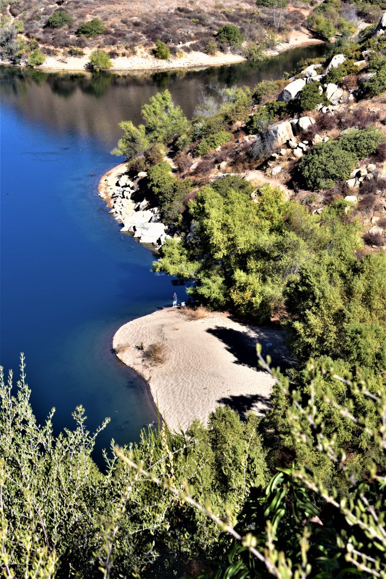
And yes, you can fish at Lake Ramona Reservoir. While bite-friendly, the huge bass population here is comprised of small largemouth because few fisherpeople want to hike up that great big hill. (Did I get enough size comparison in there to make your head spin?) Unfortunately, the bass overpopulation results in their stunted growth. Come on fisher peeps, work for it! You’re missing a beautiful opportunity. Besides, where’s the fun in driving up and parking at Lake Poway?
Lake Ramona was lovely and the reserve was pleasant enough though small. Personally, I wouldn’t go out of my way to get here, but if you’re in the neighborhood – do it.
Difficulty: Moderate + (Depends on your fitness level and the weather (heat/sun factor)
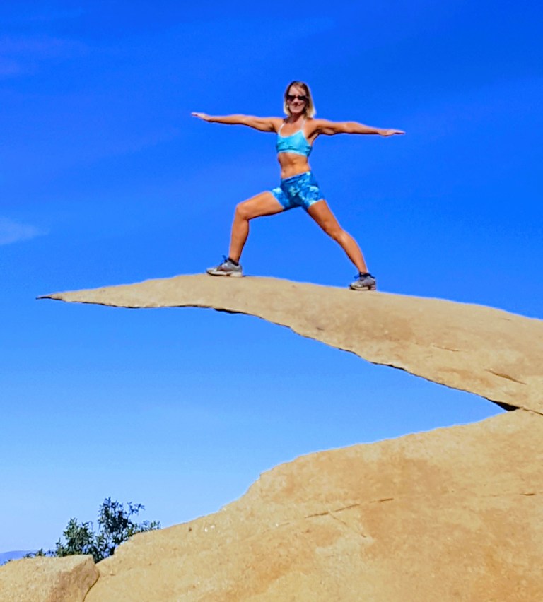
No, the featured image is not Potato Chip Rock. It’s some cool unnamed split rock along the top of the trail with a great view out to the rocky playground below and Lake Romona.
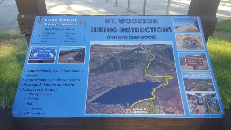
If you’re looking for solitude, you won’t find it here. This is one of the most popular hikes in San Diego because of the iconic Potato Chip Rock and obligatory photo op at the top.
Spoiler alert.
The trail starts at Lake Poway and leads you up a fire road for a mile or so before it narrows and steepens.
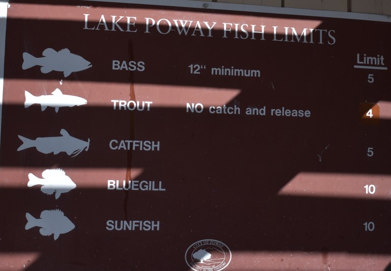
And the answer is yes, you can fish in Lake Poway. Sadly, swimming is not allowed.
Here’s the scoop
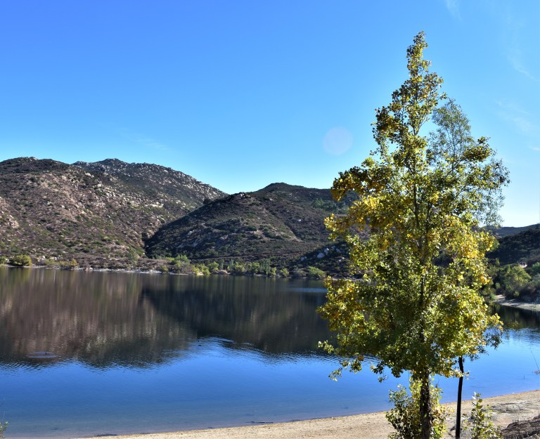
The view of the lake is lovely from the trail above. You can see how clean and clear the water is.
The view from the top depends on how clear of a day it is. Unfortunately, it was a bit hazy, In the picture below, you can make out Point Loma and the Pacific in the distant horizon on the right and the high rises of San Diego to the left of it.
.
Another cool spot along the trail – my rock throne
So yes, lots of highlights and a great workout. (I hike fast and made it up in an hour and 15min – down in 1hour 5.min.) The downhill gets my knees. There were a number of people using poles. The downside of this hike is way too many humans, but what do you expect from a cool hike near a city? If I ever do it again, I’m going for dawn patrol. The parking lot opens at 6AM for early birds who enjoy more solitude and sunrises.
Because this hike didn’t quite sate my appetite for nature and solitude, after lunch I went up the road to the Blue Sky Ecological Reserve and hiked up to Lake Ramona.
Headed to Palomar Mountain with hiking in mind and got much more out of the excursion than expected.
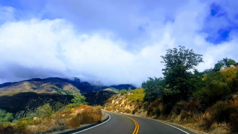
The drive up the South Grade (S6) mountain road is winding and scenic. You’ll want to keep your eyes on the road if you’re driving. Apparently this road has been compared to the L’Alpe d’Huez on the Tour de France Route so it’s popular with road cyclists, motorcyclists and sports car drivers too… Beware of those dare devil motocyclists crossing the center line as they race down the mountain
The clouds and fog made for some dramatic vistas on the way up.
The small park headquarters has a mini natural history exhibit. I didn’t know we had gray fox around here. Signs were up about a recent mountain lion sighting in the park.
Hiking Scoop
As far as the hiking here goes, most trails are short and dogs aren’t allowed on them. We did the longest loop we could find, starting at the Doane Pond, which is open for fishing year round and stocked with trout. It’s a great spot for a picnic too.
Overall, the terrain is easy on the feet – mostly dirt, not too many rocks or roots. It’s ideal for a quick trail run. (Note the seasonal tick and rattle snake warnings.)
We went up the Thunder Springs and the Silver Crest Trails and down Scott’s Cabin Trail and Chimney Flats. (Spoiler alert – the trails name is a misnomer as there is no standing cabin, just a placard at the site with no historic details on it or in the park’s brochure). The hike is interrupted by the road a couple times and the road is always within a stones throw. The good news – you won’t get lost. The bad news, if you’re a hiking snob like me, it’s a bit anticlimactic, but that’s ok – the views along the ridge, at the Boucher Hill Fire Tower, and by the Observatory are quite epic. And the road and the drive by locations make it accessible for all.
Here’s a video clip of a particularly lovely section of trail.
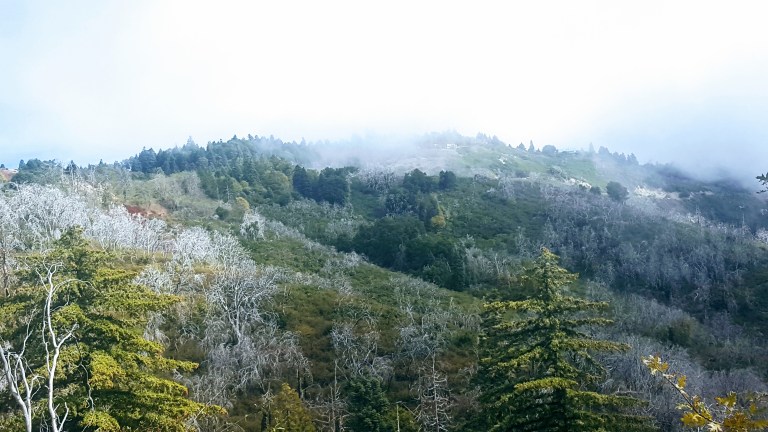
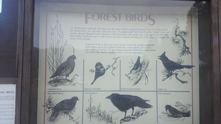
Tree lovers will delight in the variety that this section of the Cleveland National Forest yields: Douglass fir, white fir, incense cedar, live oak, black oak, coulter pine and yellow pine. Approximately 40 inches of annual rainfall keeps them thriving. Of course all these trees make it a haven for birds and bird lovers as well.
We saw all but the quail today.
Camping Scoop
The Doane valley Campground has 31 campsites, each outfitted with a table, fire ring, BBQ and food locker. Nearby restrooms have flush toilets and coin-operated hot showers. Many comforts of home in a forest setting – great for an introduction to camping. The Cedar Grove Campground has 3 areas for group camping. For more info and to reserve a spot up to 7 months in advance call 1-800-444-7275.
Enjoy Epic Views from the Boucher Hill Historic Fire Tower
The Boucher Hill Historic Fire Tower is definitely worth a stop too – whether you drive by or hike the 1.2 miles up from the visitor center. This is one of only 2 fire towers left in California. From the observation deck, you don’t even have to use the provided binocular gizmo to see the glimmering Pacific ~50 miles away.
This slideshow requires JavaScript.
Even with my bad eyes, I could make out Tamarack Tower / Smoke Stack that marks my home beach. You have to know what to look for to make it out in the video, but you can definitely tell that you’re looking out to sea.
Visit the Impressive Palomar Observatory & Museum
And no, the field trip’s not over yet. Next, we headed over to the Palomar Observatory. The structure itself is quite impressive (see feature photo), but it’s definitely worth looking inside. (Hours are 9-4 daily.) The Hale Telescope is considered one of most important scientific innovations of the last century and was the most productive and prominent telescope in the world from 1948 to 1993.
This slideshow requires JavaScript.
Don’t miss the Museum either. It’s got great displays, info and videos. The small gift shop was closed as we got there late, but I’m sure there’s some cool stuff and souvenirs for the kids in there too.
If you aren’t an astronomy or science buff going in, you might be when you leave. ..
So many fun things to do, see and learn here. Highly recommend Palomar Mountain as a field trip for the whole family. Great way to spend a Sunday afternoon.
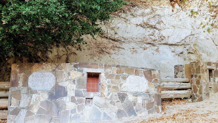
Almost forgot to mention, be sure to bring a water bottle and get your fill of refreshing fresh (and free) spring water on the way up or down at the Palomar Artesian Springs.