If you like alpine lakes, sublime scenery, and trail terrain that’s gentle on feet (good for trail running too), you’ll want to spend a day here, immersed in natural bliss. I loved this hike. The lakes and mountain scenery are SPECTACULAR. It felt easy to me despite my hiking book’s rating of it as a 4 out of 5 for difficulty due to the 2,100 ft elevation gain. The trail is quite gradual with many switchbacks, but it didn’t really seem like a big climb. Maybe I just woke up strong and altitude acclimated. The good news is the elevation gain keeps the crowds away.
There was something magical about this tree. Look for it on the trail after Lake Sherwin and let me know if it stopped you in your tracks too. The pictures don’t do it justice. I named it the Medusa tree.
If you’re not up for hiking up to Valentine Lake (9,698 ft – 5.6 miles), you can always make Sherwin Lake (2-3 miles) your destination instead, but just so you know, you’ll be missing this:
Valentine Lake, you stole my heart and nearly froze it too! I can’t resist the allure of an alpine lake, even when it’s snow melt cold. Can you?
My boyfriend was taunting me in the video below. Note: HE DID NOT JUMP IN THE LAKE. (And somehow I resisted pushing him into it.)
Distance Round Trip: 11.2 miles
Elevation Gain / Loss: 2,100
Getting There: South from Lee Vining on the 395, you’ll find Sherwin Creek Road two miles south of the Mammoth Lakes exit. Take Sherwin Creek Road west and drive ~2.5 miles and then turn left on the spur road before you reach Sherwin Creak Campground.
They say that 100-acre Lundy Lake (ele. 7,800′) is one of the most overlooked drive-to lakes in the Eastern Sierras. Named after W.J. Lundy who operated a sawmill near Lundy Lake, it’s hidden in the easily accessible foothills above Mono Lake. Part natural beauty, part manmade, originally, Lundy Lake was a smaller lake that was expanded to its current size in 1910.
I didn’t go jump in the lake as is my habit, because I only had a couple hours to Go Take a Hike and Go Chasing Waterfalls
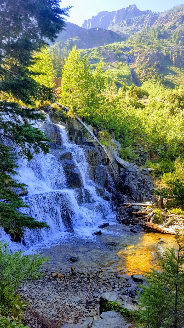
The hike was rated as a 3 for difficulty and a 9 for scenery in my old school, 1995 Cali hiking book. They were spot on for the scenery and a bit off on the difficulty level. The book said we would pass 2 small waterfalls and then at 3 miles arrive at Lake Helen to be followed by Odell Lake a mile beyond. There were many waterfalls some were narrow snow melt tracing their way down from mountain ridges above and others were thundering tiered falls along the trail–all were quite beautiful.
Snow melt tracing its way downWonderful WaterfallsGranite, Green and Rushing WaterSerene & Sublime Scenery
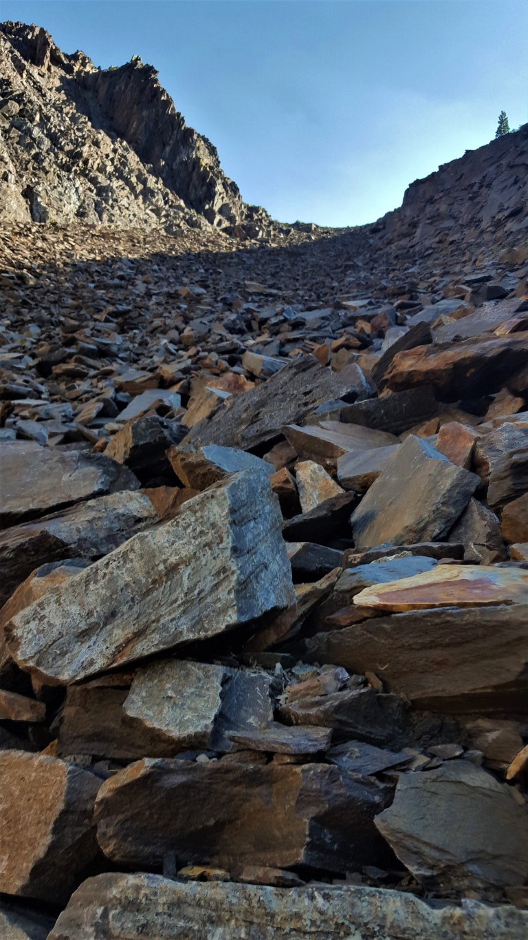
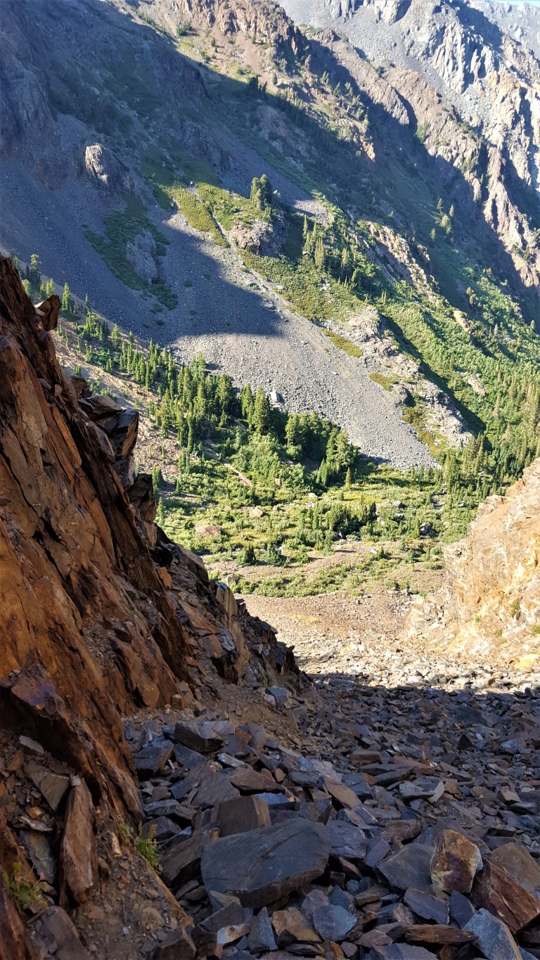
We only had a couple hours before sunset so we thought, with a good pace, we could at least make it the 3 miles to Lake Helen and back. Nope. The book didn’t mention the mountain of scree that had to be conquered before encountering Lake Helen. It also, didn’t mention that the beginning of the trail would be all but obscured due to floods and avalanches. (How could it predict 2018 conditions?) I didn’t find anything about it online either. Of course, I wanted to see what was up and around the corner of this massive mountain of scree so I kept going only to find yet another, steeper mountain of scree and no sign of the Lake Helen. Sunset was upon us so I reluctantly “skied” (not really, well maybe on my backside) the scree downhill and headed back down the trail.
Massive MT. of ScreeScree & Rockslide
A young hiker who missed her loop trail from above said she had read about the scree mountains somewhere online and knew she’d be contending with them. We gave her and her little dog, Beast, a ride back to her car on Tioga Pass. It would have been a very cold night to bed down in the woods.
Back at home as I was writing this post I discovered that AllTrails rates the trail as difficult and one person noted this: The only downside is that you can no longer reach Lake Helen due to the shale slides. The mountain has wiped out the last portion of the trail and the shale is not stable.
Oops. Just as well, I turned around when I did. I’d say it’s an easy hike if you turn around before the scree / massive rock slide, which is the safe thing to do. (Do as I say, not as I did.) Thankful the forest fairies were watching over me.
Lake Lundy is a lovely area to explore, take a dip in the lake or under a waterfall, hike and / or fish. Maybe someday I’ll be back to meet up with Lake Helen and Odell Lake when new trails are established. Note: You can approach Helen and Odell Lakes from the top instead via Tioga pass, but should stop short of the scree for safety. Happy Trails.
Go Fish
And enjoy easy shore access, the natural beauty and your fishing without the crowds. Lundy Lake is home to healthy populations of rainbow (26K stocked each season) and some large brown trout and because it lacks the pressure of some of its neighboring lakes, the fish are known for being slightly more gullible and often slightly larger than you’ll find elsewhere.
Below the lake, Mill Creek is also known for its small, wild trout population.
You’ll have your best luck in the wet years, of course.
Lundy Lake Campground: First come first serve, no reservations
36 campsites with restrooms and non-potable water.
The Lundy Lake “Resort”
RV hook ups, additional regular campsites, cabins, a general store and boat rentals in paradise.
For more information or to book reservations at the “Resort”, call 626-309-0415.
Getting there: Hoover Wilderness, Inyo National Forest: From Highway 395 north of Lee Vining, turn west onto Lundy Lake Road and follow roughly five miles to the lake and two miles beyond on the dirt road top get to the trail head.
One misty morning, I drove to the park from Santa Cruz on windy Highway 9. I turned one of the many blind corners and almost ran over a vagrant walking down the middle of the road (literally the middle of the road) pulling his rolling suitcase. Yikes. Luckily I was driving cautiously through here because when I drove into town the day before I couldn’t help but notice that the pullouts were polluted with groups of what I am going to call “car people” in various states of inebriation and agitation and ankle-deep in their own litter and debris. Yes, that was my off-putting experience with the “Santa Cruz city greeters.”
I thought early morning might be a good time to explore Henry Cowell State Park, avoid those car transients and the crowds in general. I was mostly correct.
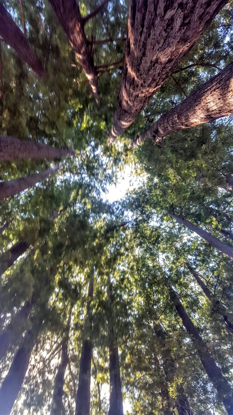
The 4,650 acre park is best known for its 40-acre grove of towering old-growth redwood trees, but it also includes 3 other habitats (grasslands, river/riparian and sand hills). The redwoods here are said to have inspired some of California’s earliest redwood preservation efforts. The tallest tree in the park is ~277 feet tall, ~16 feet wide, and estimated to be ~1,500 years old. Some trails run alongside the Sans Lorenzo River and there’s even a swimming hole.
When I arrived, the parking lot was empty as were the trails. I just ran into a couple trail runners and dog walkers.
The .8 Redwood Grove Loop trail is, of course, a must do. I also did the Cowell Highlights Loop to the Observation Deck (the park’s highest point at a meager 805 feet) Overlook Bench, Cathedral Redwoods, and Cable Car Beach about 6 miles.
It was pleasant but I never felt I was away from civilization – one “trail” is a paved road and you can hear people at the campground from different points on the trails. It’s a good place for a quick leg stretch or trail run, family hiking and camping experience. If you’re a hard-core hiker, I’d say if you miss it, you won’t miss that much. If you get it on a clear day, you might be rewarded with spectacular views of Monterrey Bay. I wasn’t, but the Santa Cruz mountains views were certainly pleasant. By the time I finished my hike, the parking lot was full of people crowding onto the trails in hopes that the mist would clear for them. It may have, but I’m glad I got out of there when I did. Go early, if you want to avoid the crowds.
This slideshow requires JavaScript.
After 2 somewhat disappointing days in Santa Cruz, I headed south for adventures in Carmel and Monterrey. They did not disappoint.
Had I known what my Santa Cruz experience would be like ahead of time, I might have decided to stop and stay awhile at Sanborn Park, instead of just doing a quickie leg stretch here.
I was enjoying driving along CA 9, taking the scenic route from San Jose airport to Santa Cruz. I’d just passed through the quaint hamlet of Saratoga when I started inhaling a fragrant, slightly cooler breeze and enjoying the dense forest shade on both sides of the winding road. That’s when I saw the sign for Sanborn County Park and decided to stop for a little explore.
Nestled in the Santa Cruz Mountains, the park covers 3,449 acres and has over 18 miles of trails amidst mixed evergreen forests of Oak, Tanborn Oak, Madrone, Redwoods and Douglass fir. During the summer, the park features the only outdoor Shakespearean company in Silicon Valley. The day use area has a 1 mile nature trail, picnic areas and restrooms – perfect for those on a road trip like me.
I read that the upper reaches of the John Nicholas Trail connect Lake Ranch Reservoir with the Skyline Trail and reward hikers with spectacular vistas of the San Francisco peninsula. (This trail that is open to all users – hikers, equestrians & mountain bikers.) If i’m ever in this area again, I’ll definitely do it. Until then a quick immersion in nature with a glimpse of wildlife was just what I needed.
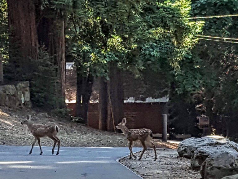
Sanborn Park Residents
Most interesting geological feature of the park is the San Andreas Fault which cuts through it diagonally.
Have you been to this park? If so, let us know what trails you did and how you liked it.
Hours: 8AM-Sunset
Day Use Entry Fee: $6
Mountain Biking: Allowed on park roads and designated trails only.
Camping: RV (year-round) & Tent (April through October)
Getting there: The main park entrance is on Sanborn Road, about 1.75 miles from Saratoga via CA 9.
A crown jewel indeed. Point Lobos is absolutely breathtaking. The pristine rugged seascape here is brimming with life. A small park from a hiking trail mileage perspective – about 6 miles total – this park delivers big with stunning, spectacular vistas. Here, you’ll encounter plant communities, archeological sites, geological formations, and the incredibly rich flora and fauna of the jagged landscape and rolling surf. There’s also a whaling museum on site.
Blue Heron MediataionCharming, Secluded CovesThe Carmelite Monastery of the cloistered Sisters by The Sea, a heavenly spot to cultivate spirituality.
Sea Blues by Monastery BeachWildflowers and Wild ViewsPoint Lobos is home to 3 species of trees: the Monterey Pine, the Coast Live Oak, and the Monterey Cypress. The Allan Memorial Grove in Point Lobos is a native stand for the Monterey Cypress, which is listed as a Category 1 rare and endangered species,
This is an absolute must do if you’re in the area. The trails are all quite accessible and you don’t have to go far to feel like you in the midst of the coastal wild. If you’re like me, you won’t want to leave. It’s a mesmerizing, magical place. (It’s like California before man.) We are so fortunate to have this area preserved. So grateful to the Point Lobos Foundation for protecting this natural wonder and national treasure. A great destination for nature lovers, painters, photographers, poets and all artists and pantheists alike. (The foundation actually puts on a poetry walk / Haiku hike- how cool is that???!)
This is my bliss. Soaking in the natural beauty as I channel Copenhagen’s Little Mermaid.
Given that Point Lobos State Marine Reserve is one of California’s richest marine habitats, it is a scuba diver’s, snorkeler’s, kayaker’s, stand-up paddler’s paradise with 70 foot kelp forests brimming with lingcod, rockfish, harbor seals and sea otters.
Diving is allowed only at Whalers and Bluefish Coves. Proof of certification is required. Reservations are recommended for the weekdays and are a must for weekends and holidays.
Stand-up-paddle and kayaking are also allowed in the Reserve. (There’s a $10 fee to launch from Whaler’s Cove. You can also launch from Monastery Beach, 1/4 mile north of the park.) This would be an exceptional way to explore the captivating coves and coastal. Surprised I didn’t see anyone kayaking or stand-up paddling here; it was a perfect day with glassy calm water. Next time, I’m going for a SUP tour of my own. And yes, there will be a next time, because once you visited, all you can think about is going back.
Notes:
Poison oak flourishes here and is everywhere. While the park does its best to keep the trails clear and rope off areas, they can’t keep up with the robust growth. Pants and long sleeves are recommended. Keep an eye on young children with wandering hands…
No pets allowed in the reserve or left in parked cars.
Keep a minimum 50 feet away from marine mammals.
Dangerous conditions, including rip currents occur – be ocean-wise and safe.
Hours: 8AM-7PM
Address: 62 California 1, Carmel-By-The-Sea, CA 93923
Fees: You can park and enter for free via Coast Highway (their small parking lot is often full), otherwise it’s $10 to park, $5 for Seniors & Disabled.

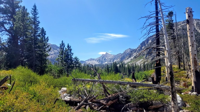


 Valentine Lake, you stole my heart and nearly froze it too! I can’t resist the allure of an alpine lake, even when it’s snow melt cold. Can you?