Mt. Whitney: Deja Vu: Repeat hiking the highest peak in the Continental US (24 years later)

L  and K Whitney sign cropped.JPG
All smiles at the start. Pack Weight: His 40 lbs & Hers 20 lbs

Whitney Route

Distance: 22 mi, rt

Difficulty: Yes, challenging – all depends on your fitness level & your knee health. Peak is 14, 505 ft elevation with a gain & loss of 6,100 ft & rocky, uneven, occasionally treacherous terrain. If you have arthritis in your knees, like me, going down is going to hurt. A lot. Even with poles.

First of all, I probably wouldn’t have done Whitney again since I’d already been there and done that (1994) and I’m not much for redos.

20180831_150037
Circa 1994

But we were up in the area. And my swim buddy, Rosie, and a group of her friends were doing it, and Ken wanted to do it, so I figured let’s leave it to fate.

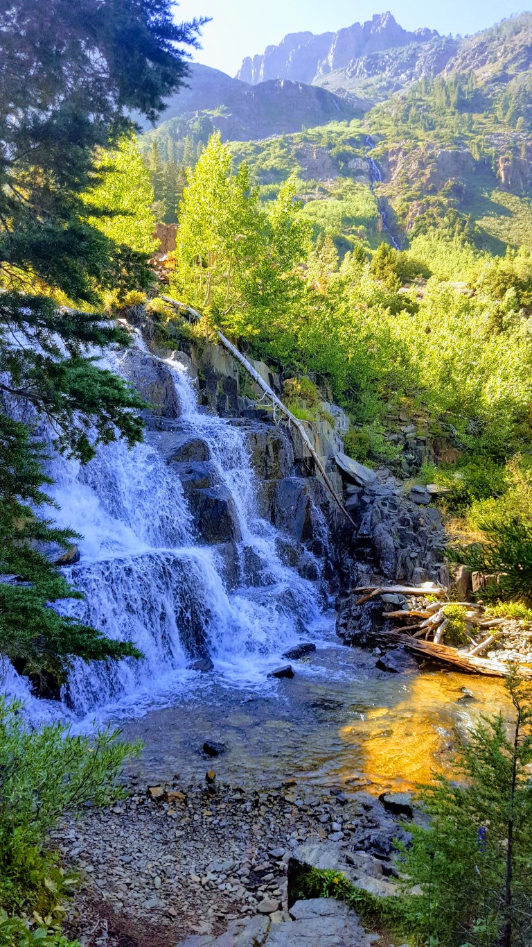
If we’re able to get a last-minute permit, we’ll do it. We had planned on doing at least 1 overnighter anyway so why not make it Whitney? Trouble is, day hike and overnight permits for Whitney are tough to get–only about 15% of people who want a permit get a permit so I didn’t have high hopes. No big deal, there are so many wonderful places to explore in the sierras, we were just winging it day by day anyway. We’d started in the Mammoth area 2 days prior and had already enjoyed a short lovely waterfall-filled, sunset hike with a tricky ending at Lundy Lake and a spectacular 11 mile day hike to Valentine Lake.

We raced down from Mammoth Lakes to Lone Pine and  lined up at the Ranger and Visitor Center at 11AM sharp as instructed. Ken picked a lucky  #3 out of the hat, which put us in the lead to capture a spot. Fate would have it that Mt. Whitney and I would meet again. Off we went equipped with the requisite bear canister.

Note the trail is difficult (altitude, terrain, length, elevation gain/loss). Many people train and prepare for months to do it. We are both endurance athletes and accustomed to pushing our boundaries (sometimes we are [i am] a bit too ambitious though  – see our Catalina mt. bike adventure). While we were a little concerned about altitude sickness, we were relatively sure we could handle the hike.

Our trip to the mountains was last minute. We packed up in about 30 minutes and accidentally left out some key items (water purifier, hats, gloves, headlamps) at home. We stopped at the Lone Pine grocery and loaded up on munchies and water and then strolled across the street to pick up a couple headlamps at the Outfitters store.

Note, we were not prepared for high-altitude sub-freezing temps the night we camped (without a tent to keep the packs light) and the morning we hiked to the peak. I’m going to put together a camping checklist and post it here so we don’t leave home without the essentials again.

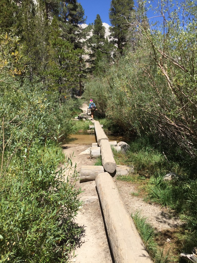
We could have cut the weight in our packs significantly if we’d brought the water purifier. Contrary to memory of 1994 there was plenty of water along the trail and at Trail Camp – lakes, streams and waterfalls.

IMG_3569

We started on the trail at 2:30 PM with the goal of camping at Trail Camp 6 miles up, elevation 12,000 ft. I had a vision of sunrise on the peak that I wanted to fulfill – that would certainly make hiking this monster twice worth it. I had no memory of the lovely lakes, streams, and waterfalls (perhaps it was a dry year) and the beauty of the Whitney.

Note there is an earlier opportunity to camp near a waterfall at Outpost Camp just 3.8 miles up and 10,800 feet elevation.


IMG_3535

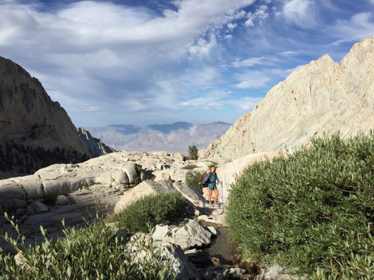
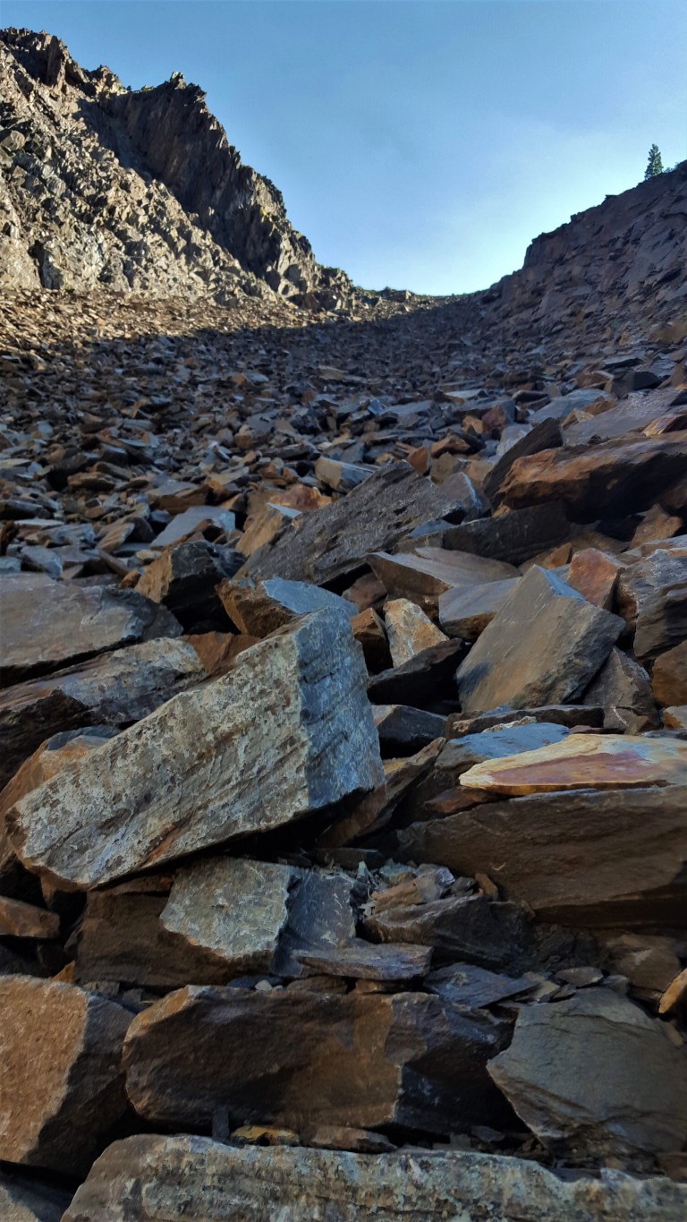
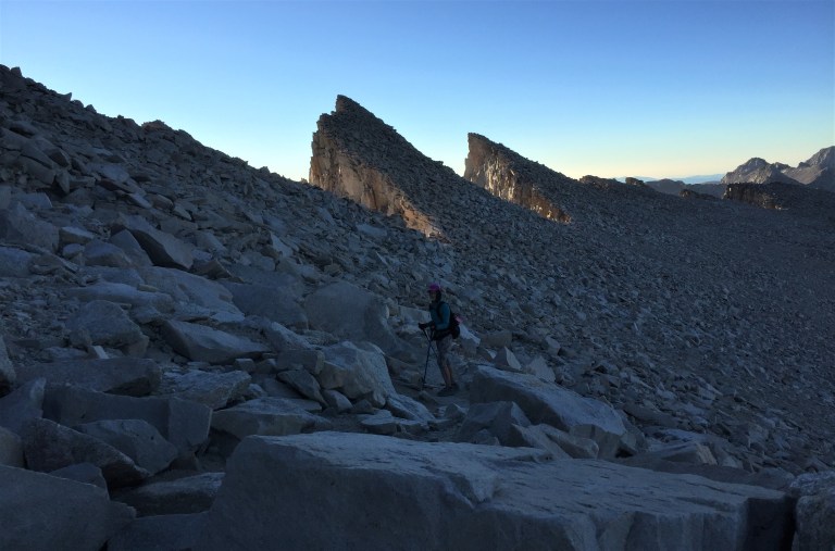
About a mile after Outpost Camp the terrain begins to get a bit more ornery (rocky)…Of course, the views become more beguiling to take your mind off the occasionally tortuous footing. Speaking of footing, I hiked both times in trail runners. Ken wore running shoes and said his feet took quite a beating. It’s really personal preference. A visual poll of hikers, coming and going, was about 50/50 hard-toe hiking shoes, running / trail running shoes.

Some hikers wore no shoes at all.

marmot

IMG_3536


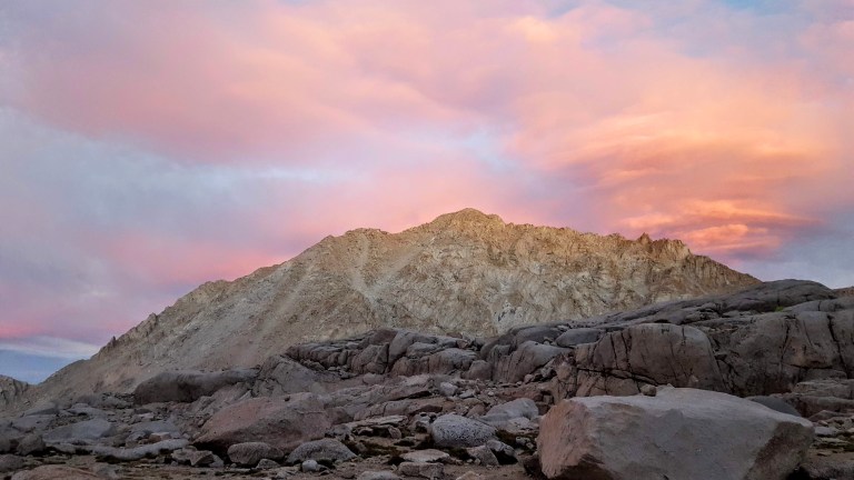
We arrived at Trail Camp at 6:30 PM just in time for sunset. At least a half dozen other hiking parties had already set up their tents. We laid out our mats and sleeping bags. I jumped in immediately, the temperature was already dropping. The video and the picture below were taken from my sleeping bag vantage point. How dreamy to experience sunset on Whitney and (fingers-crossed) sunrise too.

Trail Camp Sunset

After chowing down on some nuts, Slim Jim’s and other munchies “in bed”, Ken put the bear canister ~150 yards away and it was lights out. My plan was for a 3:30 AM start. We didn’t sleep much—it was quite chilly (understatement). At 2:30, I saw another group rustling around with their headlamps and beginning their hike to summit. We got our start around 30 minutes later, rising at the crack of darkness to make a run for sunrise at the summit. Watching the string of headlamps bobbing in the darkness ahead and above us, snaking around the ridges through the infamous 97 switch backs was like being in an adventure film. I wish I had taken some pictures or videos, but my phone battery was low and my hands were freezing, despite my improvised sock mittens.

Unfortunately, my headlamp failed (note to self – bring extra batteries – duh). Since my eyesight is so bad, Ken let me lead with the other headlamp. The footing is quite tricky and some areas were wet so it slowed us down a bit. (The puddles had turned to ice when we reached them on the way back.)

trail crest
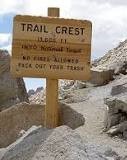
When we arrived at Trail Crest, the highest trail pass in the US (13,645 ft) it was still pitch dark and we were half -asleep and perhaps a bit altitude touched. Somehow, we misread the sign and went the wrong way – going about 1/2 mile off course. We thought it was odd that we’d be descending before the peak, but we saw some headlamps down there and none in the other direction…Despite the wrong turn, we made it to the top in time for one of the most memorable sunrises of my life.


Dawn on Whitney

Land K top


This time, no altitude sickness at all, but you can hear me slurring my speech a tad in the video – from the cold & altitude (no mimosas, unfortunately). These past 24 years and my history of running have not been kind to my knees so the way down was much harder (hurt more) than the way up. Not sure I’ll be back again, but ya never know. Maybe I should do it every 24 years? Maybe not. Anyway, it was totally worth it.

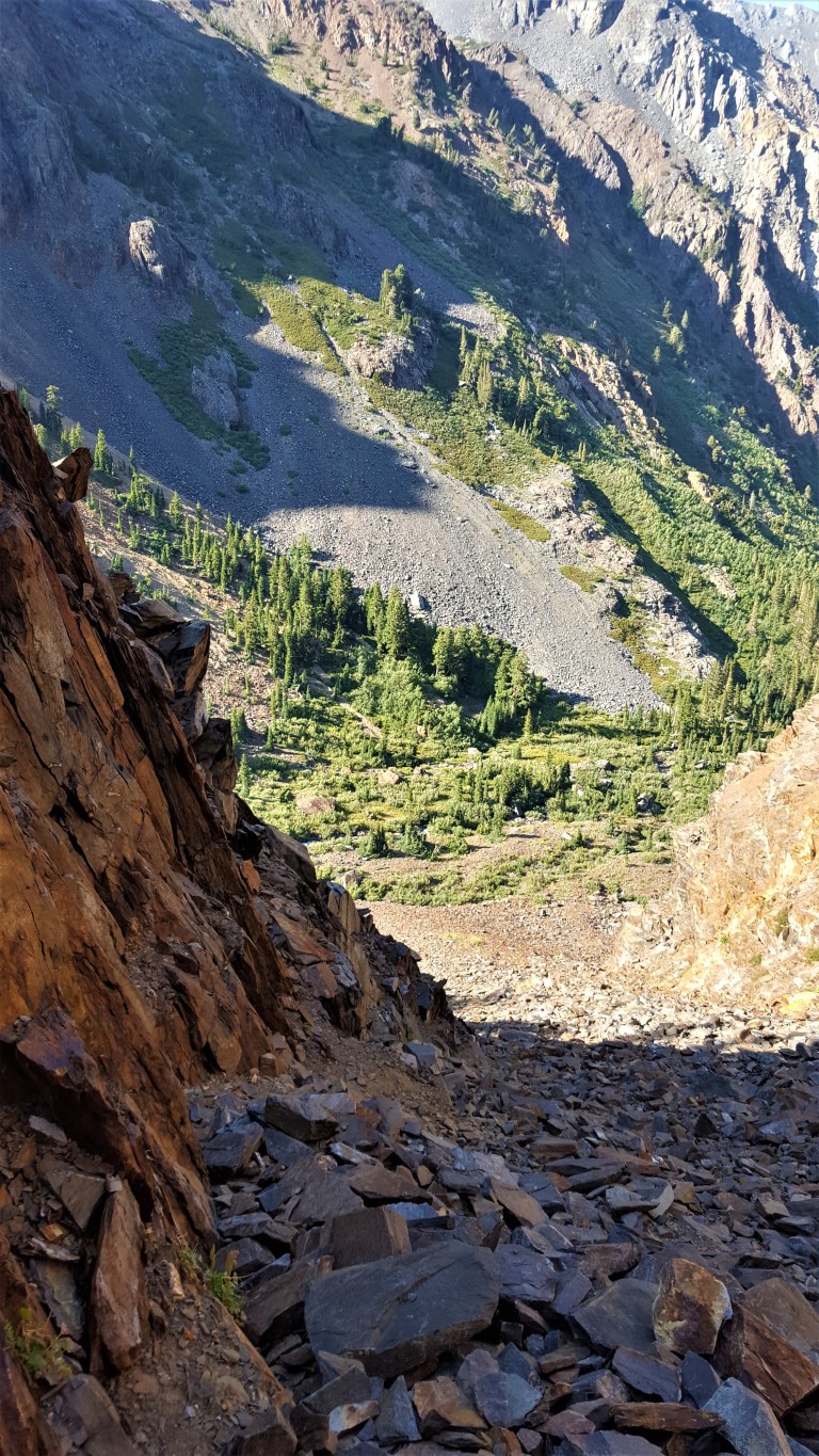
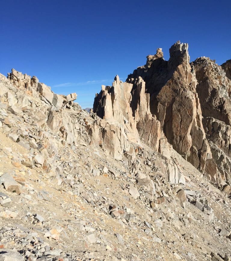
The steep drop-offs on the upper trail were equally daunting in the dark and in the daylight.

IMG_3564

IMG_3563

IMG_3560

IMG_3549
Yes, those are socks on my frozen hands.

The view of a few of the infamous 99 switchbacks and the little lake by Trail Camp on the way down.

switchbacks.JPG


Ran into my swim buddy, Rosie, on the way down – her way up.

Image may contain: 2 people, people smiling, mountain, sky, outdoor and nature
Ran into my swim buddy, Rosie, on my way down – her way up.

We made it back to Trail Camp by 9AM and out the bottom by 1:30PM – all in a days work – 23 hrs with camping. I recommend camping if you can, you get to enjoy the hike more and see more.

Many thanks to Ken for capturing and sharing his great photos on this post, for always being a great sport on my crazy escapades, and for carrying the heavier pack.

20180822_134536
After – still smiling

My toenail causality. Guess my foot modeling days are over.

20180906_145321.jpg

Getting there: Take Whitney Portal road from Lone Pine

Permit details: https://www.recreation.gov/wildernessAreaDetails.do?contractCode=NRSO&parkId=72201


Sherwin Creek Trail: Awesome Hike to 2 Spectacular Lakes. Mammoth Lakes, CA.

If you like alpine lakes, sublime scenery, and trail terrain that’s gentle on feet (good for trail running too), you’ll want to spend a day here, immersed in natural bliss. I loved this hike. The lakes and mountain scenery are SPECTACULAR. It felt easy to me despite my hiking book’s rating of it as a 4 out of 5 for difficulty due to the 2,100 ft elevation gain. The trail is quite gradual with many switchbacks, but it didn’t really seem like a big climb. Maybe I just woke up strong and altitude acclimated. The good news is the elevation gain keeps the crowds away.

peaks and timber


There was something magical about this tree. Look for it on the trail after Lake Sherwin and let me know if it stopped you in your tracks too. The pictures don’t do it justice. I named it the Medusa tree.


If you’re not up for hiking up to Valentine Lake (9,698 ft – 5.6 miles), you can always make Sherwin Lake (2-3 miles) your destination instead, but just so you know, you’ll be missing this:


Lydia Valentine lake
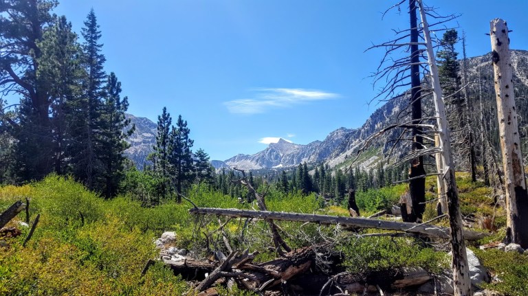
Valentine Lake, you stole my heart and nearly froze it too! I can’t resist the allure of an alpine lake, even when it’s snow melt cold. Can you?

My boyfriend was taunting me in the video below. Note: HE DID NOT JUMP IN THE LAKE. (And somehow I resisted pushing him into it.)


Distance Round Trip: 11.2 miles

Elevation Gain / Loss: 2,100

Getting There: South from Lee Vining on the 395, you’ll find Sherwin Creek Road two miles south of the Mammoth Lakes exit. Take Sherwin Creek Road west and drive ~2.5 miles and then turn left on the spur road before you reach Sherwin Creak Campground.


Exploring the Lovely Lundy Lake Trail, Hoover Wilderness, Inyo National Forest

Go Jump in the Lake

They say that 100-acre Lundy Lake (ele. 7,800′) is one of the most overlooked drive-to lakes in the Eastern Sierras. Named after W.J. Lundy who operated a sawmill near Lundy Lake, it’s hidden in the easily accessible foothills above Mono Lake. Part natural beauty, part manmade, originally, Lundy Lake was a smaller lake that was expanded to its current size in 1910.

I didn’t go jump in the lake as is my habit, because I only had a couple hours to Go Take a Hike and Go Chasing Waterfalls

The hike was rated as a 3 for difficulty and a 9 for scenery in my old school, 1995 Cali hiking book. They were spot on for the scenery and a bit off on the difficulty level. The book said we would pass 2 small waterfalls and then at 3 miles arrive at Lake Helen to be followed by Odell Lake a mile beyond. There were many waterfalls some were narrow snow melt tracing their way down from mountain ridges above and others were thundering tiered falls along the trail–all were quite beautiful.

snow melt fall
Snow melt tracing its way down
3 tiered waterfall
Wonderful Waterfalls
granite, gree nand water fall
Granite, Green and Rushing Water
Along the Lundy Lake Trail
Serene & Sublime Scenery

We only had a couple hours before sunset so we thought, with a good pace, we could at least make it the 3 miles to Lake Helen and back. Nope. The book didn’t mention the mountain of scree that had to be conquered before encountering Lake Helen. It also, didn’t mention that the beginning of the trail would be all but obscured due to floods and avalanches. (How could it predict 2018 conditions?) I didn’t find anything about it online either. Of course, I wanted to see what was up and around the corner of this  massive mountain of scree so I kept going only to find  yet another, steeper mountain of scree and no sign of the Lake Helen. Sunset was upon us so I reluctantly “skied” (not really, well maybe on my backside) the scree downhill and headed back down the trail.

second mt of scree
Massive MT. of Scree
scree descent
Scree & Rockslide

A young hiker who missed her loop trail from above said she had read about the scree mountains somewhere online and knew she’d be contending with them. We gave her and her little dog, Beast, a ride back to her car on Tioga Pass. It would have been a very cold night to bed down in the woods.

Back at home as I was writing this post I discovered that AllTrails rates the trail as difficult and one person noted this: The only downside is that you can no longer reach Lake Helen due to the shale slides. The mountain has wiped out the last portion of the trail and the shale is not stable. 

Oops. Just as well, I turned around when I did. I’d say it’s an easy hike if you turn around before the scree / massive rock slide, which is the safe thing to do. (Do as I say, not as I did.) Thankful the forest fairies were watching over me.

Just me and the forest faires

Lake Lundy is a lovely area to explore, take a dip in the lake or under a waterfall, hike and / or fish. Maybe someday I’ll be back to meet up with Lake Helen and Odell Lake when new trails are established. Note: You can approach Helen and Odell Lakes from the top instead via Tioga pass, but should stop short of the scree for safety. Happy Trails.

 Go Fish

And enjoy easy shore access, the natural beauty and your fishing without the crowds. Lundy Lake is home to healthy populations of rainbow (26K stocked each season) and some large brown trout and because it lacks the pressure of some of its neighboring lakes, the fish are known for being slightly more gullible and often slightly larger than you’ll find elsewhere.

Below the lake, Mill Creek is also known for its small, wild trout population.

You’ll have your best luck in the wet years, of course.

Lundy Lake Campground: First come first serve, no reservations

36 campsites with restrooms and non-potable water.

The Lundy Lake “Resort”

RV hook ups, additional regular campsites, cabins, a general store and boat rentals in paradise.

For more information or to book reservations at the “Resort”, call 626-309-0415.

Getting there: Hoover Wilderness, Inyo National Forest: From Highway 395 north of Lee Vining, turn west onto Lundy Lake Road and follow roughly five miles to the lake and two miles beyond on the dirt road top get to the trail head.

A Romp Around in Henry Cowell Redwoods State Park, Felton CA

One misty morning, I drove to the park from Santa Cruz on windy Highway 9. I turned one of the many blind corners and almost ran over a vagrant walking down the middle of the road (literally the middle of the road) pulling his rolling suitcase. Yikes. Luckily I was driving cautiously through here because when I drove into town the day before I couldn’t help but notice that the pullouts were polluted with groups of what I am going to call “car people” in various states of inebriation and agitation and ankle-deep in their own litter and debris. Yes, that was my off-putting experience with the “Santa Cruz city greeters.”

I thought early morning might be a good time to explore Henry Cowell State Park, avoid those car transients and the crowds in general. I was mostly correct.

The 4,650 acre park is best known for its 40-acre grove of towering old-growth redwood trees, but it also includes 3 other habitats (grasslands, river/riparian and sand hills). The redwoods here are said to have inspired some of California’s earliest redwood preservation efforts. The tallest tree in the park is ~277 feet tall, ~16 feet wide, and estimated to be ~1,500 years old. Some trails run alongside the Sans Lorenzo River and there’s even a swimming hole.

When I arrived, the parking lot was empty as were the trails. I just ran into a couple trail runners and dog walkers.

The .8 Redwood Grove Loop trail is, of course, a must do. I also did the Cowell Highlights Loop to the Observation Deck (the park’s highest point at a meager 805 feet) Overlook Bench, Cathedral Redwoods, and Cable Car Beach about 6 miles.

It was pleasant but I never felt I was away from civilization – one “trail” is a paved road and you can hear people at the campground from different points on the trails. It’s a good place for a quick leg stretch or trail run, family hiking and camping experience. If you’re a hard-core hiker, I’d say if you miss it, you won’t miss that much. If you get it on a clear day, you might be rewarded with spectacular views of Monterrey Bay. I wasn’t, but the Santa Cruz mountains views were certainly pleasant. By the time I finished my hike, the parking lot was full of people crowding onto the trails in hopes that the mist would clear for them. It may have, but I’m glad I got out of there when I did. Go early, if you want to avoid the crowds.


This slideshow requires JavaScript.

After 2 somewhat disappointing days in Santa Cruz, I headed south for adventures in Carmel and Monterrey. They did not disappoint.


Henry Cowell State Park 101 North Big Trees Park Road, Felton CA 831.335.4598

Campground 2951 Graham Hill Road, Scotts Valley, CA  831.438.2396