Had I known what my Santa Cruz experience would be like ahead of time, I might have decided to stop and stay awhile at Sanborn Park, instead of just doing a quickie leg stretch here.
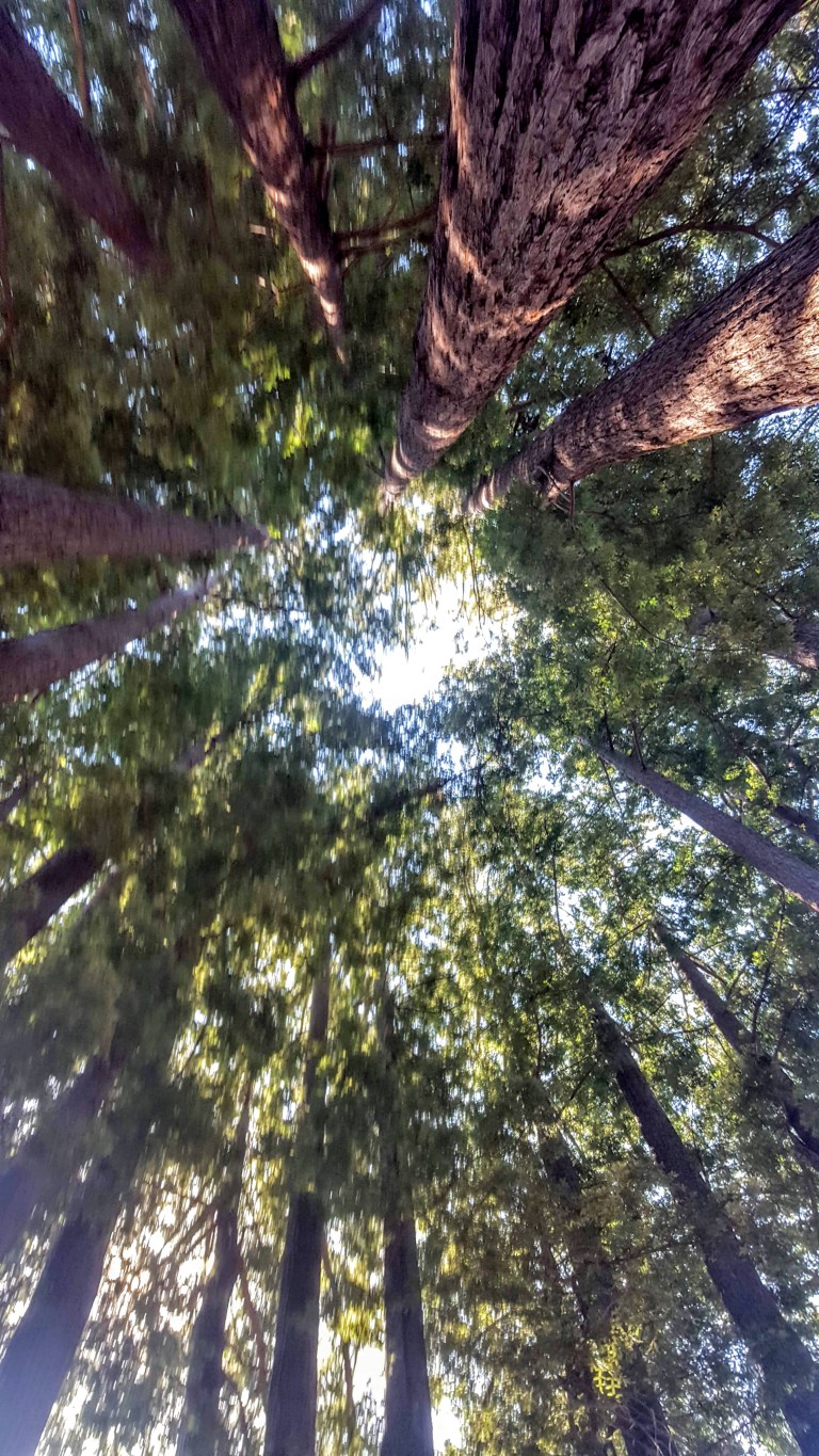
I was enjoying driving along CA 9, taking the scenic route from San Jose airport to Santa Cruz. I’d just passed through the quaint hamlet of Saratoga when I started inhaling a fragrant, slightly cooler breeze and enjoying the dense forest shade on both sides of the winding road. That’s when I saw the sign for Sanborn County Park and decided to stop for a little explore.
Nestled in the Santa Cruz Mountains, the park covers 3,449 acres and has over 18 miles of trails amidst mixed evergreen forests of Oak, Tanborn Oak, Madrone, Redwoods and Douglass fir. During the summer, the park features the only outdoor Shakespearean company in Silicon Valley. The day use area has a 1 mile nature trail, picnic areas and restrooms – perfect for those on a road trip like me.
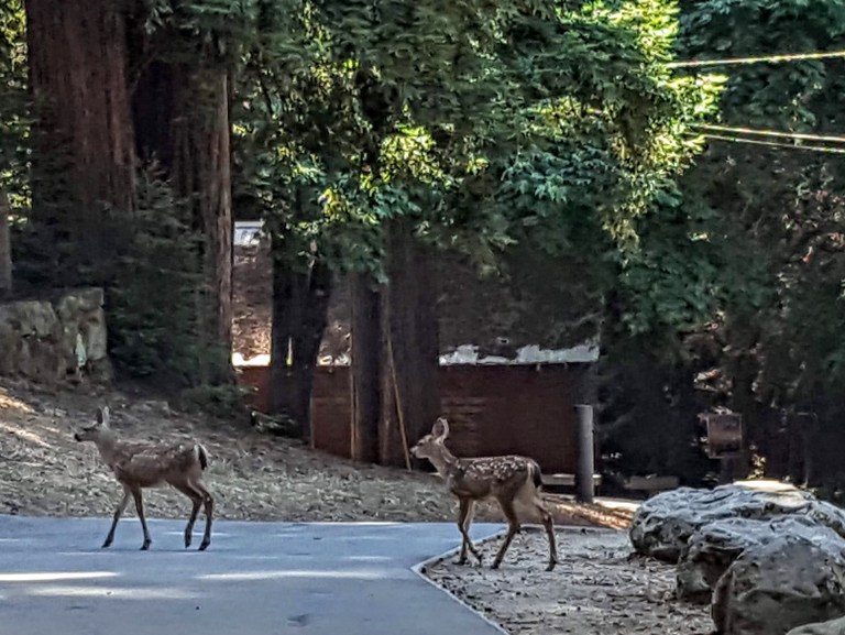
I read that the upper reaches of the John Nicholas Trail connect Lake Ranch Reservoir with the Skyline Trail and reward hikers with spectacular vistas of the San Francisco peninsula. (This trail that is open to all users – hikers, equestrians & mountain bikers.) If i’m ever in this area again, I’ll definitely do it. Until then a quick immersion in nature with a glimpse of wildlife was just what I needed.
Sanborn Park Residents
Most interesting geological feature of the park is the San Andreas Fault which cuts through it diagonally.
Have you been to this park? If so, let us know what trails you did and how you liked it.
Hours: 8AM-Sunset
Day Use Entry Fee: $6
Mountain Biking: Allowed on park roads and designated trails only.
Camping: RV (year-round) & Tent (April through October)
Getting there: The main park entrance is on Sanborn Road, about 1.75 miles from Saratoga via CA 9.
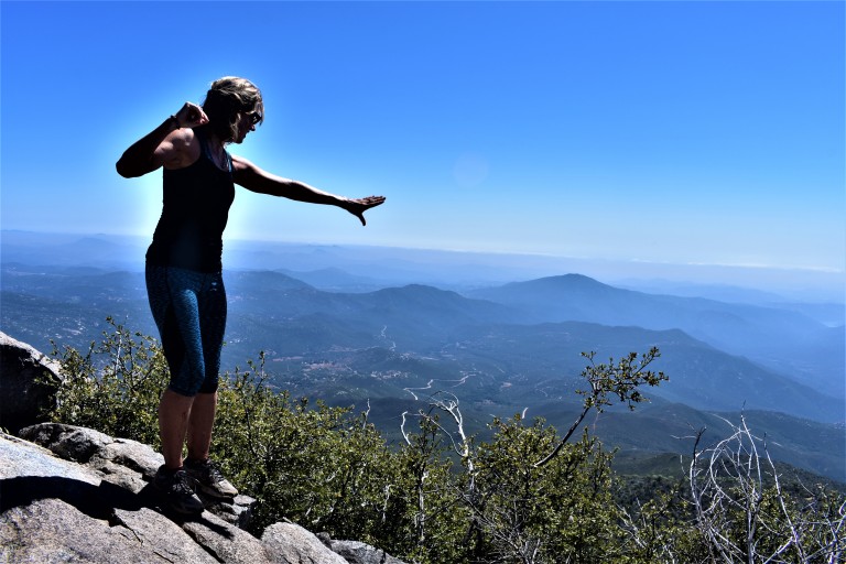
Cuyamaca Peak‘s little sister, Stonewall Peak, (5,730 feet) outshines her big sister with her stunning granite crown, haunting tree skeletons (remnants of the Cedar Fire) and lovely vistas of Cuyamaca State Park and out to Anza Borrego. Before I moved to North County and started exploring the area, I had no idea that all this wonderful natural beauty is an easy drive from greater San Diego.
Gradual ascent on a friendly trail
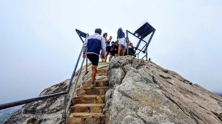
Expansive viewsInteresting rock formations along the wayStairway to heavenly vistas
Something about these beautiful trees and bouldersA bit crowded at the actual peak – silly people looking down at their phonesLovely Lake Cuyamaca views on the way downA sprinkling of dazzling wildflowers
Takes you back to the start
Biggest Dandelion Ever???
Planning your Cuyamaca adventure
You can make it a day or a weekend adventure and do as much or as little hiking as you like. Ambitious, fit hikers can take on both peaks (Cuyamaca & Stonewall) in a day. For the less ambitious, there are plenty of opportunities to add on easy short strolls by the lake and up to Stonewall Mine. Lots of wildlife viewing with trails for the whole family. Stay tuned for my next post. Happy trails!
The historic gold mining town of Julian is a mile or two away with its quaint shops, B&Bs, restaurants and famous pies.
Notes: This is the most popular hike in the park so go early to avoid the crowds. After you reach the Stonewall Peak spur trail and make a right, there’s a really short scramble over some rocks before you hit the last rocky stairway. Keep your eyes open for the metal handrails. On the way back, I recommend taking a right at the junction for a different route down ton what becomes a pleasant single track trail d. At about 3.7 miles, you come to a trail intersection. Make the left onto Vern Whitaker Trail. Shortly after that (around 3.9 miles) there’s another junction, continue to stay left. At 4.2 miles or so,you’ll encounter another side trail; stay your course to the left again.
Miles: ~<4 miles rt if you just go up and down the main trail. My scenic route adds about a mile & a half for ~5.5 miles rt.
Elevation gain: 1,050 feet
Terrain: Mostly sweet, clear terrain (as in trail runnable). It’s gets a bit rocky and pesky for a while near the top so watch your footing. .The single track down was mostly friendly.
Difficulty: Easy to moderate. Depends on your fitness level and the route you take.
Trailhead: Across the street from the Paso Picacho campground, Cuyamaca State Park
Parking: $10 State Park Fee
Dogs: Only allowed on paved roads and must be leashed.
Camping: Paso Picacho campground has family campsites with tables, firepits, running water and bathrooms.
It’s relatively easy to “bag”the second highest peak in San Diego County as it tops out at just 6,515 feet. You’ve got a choice between two routes or a combo of them. I opted for the scenic trails up and took the paved road down to make a loop. Views were good on both routes, but far more solace, solitude and wildflowers on the less traveled, natural trail.
In 2003, the Cedar Fire , California’s biggest wildfire (started by a lost hunter who lit a signal fire that burned out of control) decimated 290, 278 acres, including 90% of the Park’s 24,700 acres. The ravages from that fire are still rampant, but these formerly rich forest (oaks, willows, adlers, and sycamore tress, cedar, white fir, ponderosa, Coulter, sugar and Jeffrey pine) and meadowlands are slowly making a comeback. More than 100 bird species abound in the park, including acorn woodpeckers, northern flickers and red tailed hawks, Mammals you might encounter here include gray fox, badger, bobcat, mountain lion and deer.
Azelea Glen Loop Trail
If you reach this sign, refill you water at the spring, but you want to turn back and follow the fireroad about a 1/4 mile to the Coneja Trail connector and take that on up to the peak.
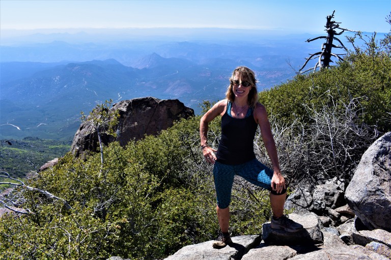
At the top
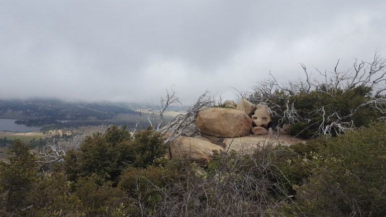
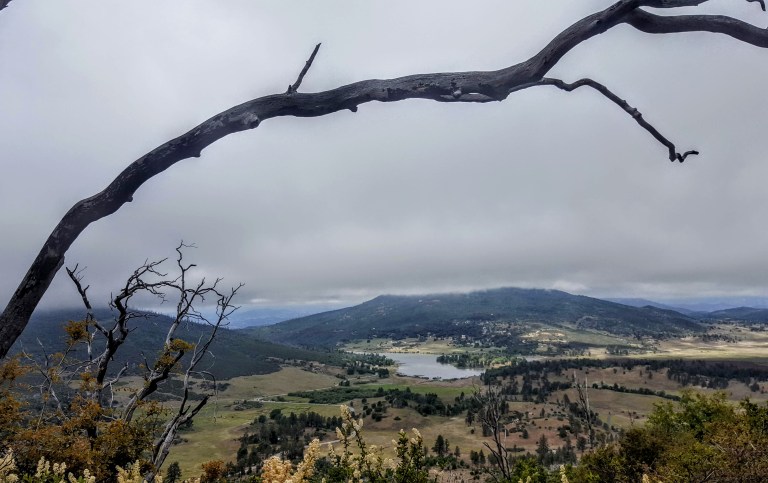
Unfortunately, it wasn’t a clear day so the Salton Sea and Anza-Borrego Desert to the east and Pacific coastline to the west and all the mountain vistas surrounding were a bit difficult to discern.
Is it just me or does the burnt tree in the picture above evoke an Indian chief bowing his head? (Kumeyaay Indians occupied the Cuyamaca mountains from antiquity until around 1857.)
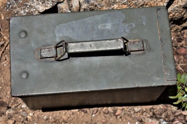
You can document your peak bagging effort by opening this box and signing in.
Views to Lake Cuyamaca and the Valley belowA framed view of Stonewall PeakA closer view of Stonewall Peak
There are plenty of other trails to explore nearby including a switchback trail up and down alluring Stonewall Peak (4 miles rt) and hidden waterfalls somewhere…(I’ll let ya know when I find them.) If I’d had more time I would have done Stonewall too. (The trail head is right across the campground entrance.) There’s more than a 100 miles of trails for hiking, horseback riding and a select number for mountain biking here. I’ll be back.
Planning your excursion
You can make a day or a weekend of your Cuyamaca adventure. The historic gold mining town of Julian is a mile or two away with its quaint shops, B&Bs, restaurants and famous pies.
Notes
Miles: 7.7 miles rt (Or just 5 miles rt if you take the paved road both ways.)
Elevation: 1700 ft gain/ loss
My route: Azelea Glen Loop to Azalea Glen Road. Make a right on the Azalea Fire Road, a left on the single track Conejo Trail that comes up in a 1/4 mile. The Conejo Trail hooks up with Lookout Fire Road about a 1/2 mile from the top – the steepest portion.)
Terrain: Mostly sweet, soft terrain (as in trail runnable), until you get to the Conejo Trail. It’s gets a bit rocky and pesky for a while on there so watch your footing. (Another reason I chose the paved road downhill.)
Difficulty: Moderate. Depends on your fitness level and the route you take. The 1/2 mile incline at the top is tough, but it’s all quite reasonable. I brought hiking poles but did not bring take them on the trail and was fine. (I have bad knees.) It would be a bit relentless to take the paved road up. (I wouldn’t mind trying it on a mtb bike. Heard about some people who did on road bikes – that’s a little nutty. Took me 2 hours up and 40 minutes down – no running…
Trailheads: Both the paved Lookout Fire Road & the Azelea Glen Loop begin at the Paso Picacho campground, Cuyamaca State Park
Parking: $10 State Park Fee
Dogs: Only allowed on paved roads and must be leashed.
Camping: Paso Picacho campground has family campsites with tables, firepits, running water and bathrooms.
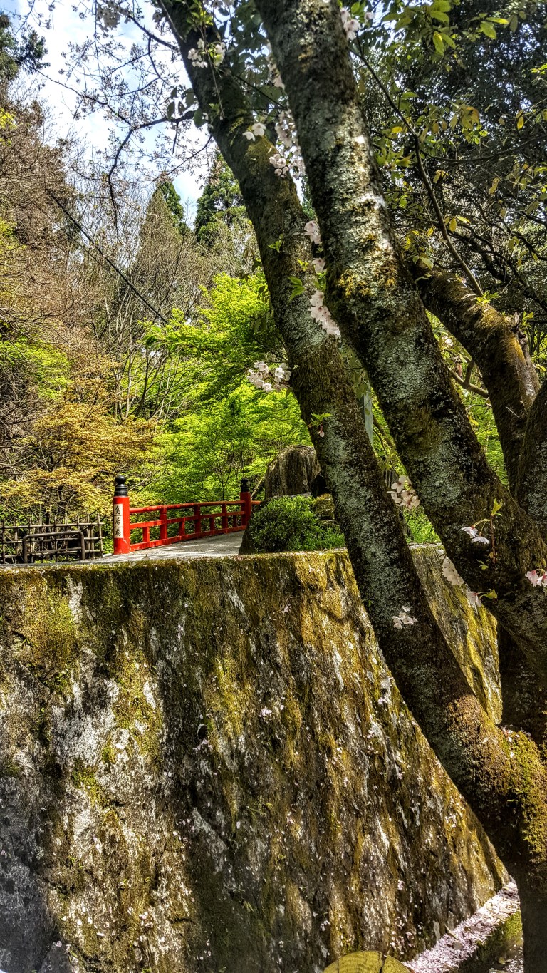
Kyoto is surrounded by mountains on three sides so the opportunities to hike abound. I haven’t been able to locate my trail notes on this one so I’m just going to post some photos from my Kyoto walkabout for now.
Sometimes your future
is clear and inviting. The
bridge appears; you cross.
Hmm…
Sometimes it’s hard to
know which way to go so let
the forest guide you.
Magical dappled light – must be the enlightened path
Find yourself in the
dazzling, dappled light-your path
to enlightenment.
Hidden shrines
Traditional buildings and cherry blossomsTemples
Never too far from civilizationSome signs are more helpful than others…Trail markers like this one at key intersections between Kyoto suburbia & Kyoto Forest trails were very helpful.
Cowles Mountain (1,593-foot summit) is the highest point in the city of San Diego. It’s part of Mission Trails Regional Park, a 5,800-acre open space preserve that is the 7th-largest open space urban park in the United States. It contains sixty miles of hiking, mountain bike and equestrian trails.
To call Cowles a mountain is to be very liberal with the word. I should note that the park has a 5 “peak” challenge if your hiking peeps want a minor challenge and want to document your feats – here’s the scoop. Cowles is the highest peak. This might be fun for kids, but apparently lots of adults do it for bragging rights too. I will say that on a clear day, the stunning views span 360 degrees from Lake Murray, downtown San Diego, Point Loma, La Jolla, and Mexico and out across the glimmering Pacific to the San Carlos Islands. See feature picture above. (Unfortunately, I dropped my camera on a rock so I have limited pics.)
Distance: 2.9 miles up & back
It’s a very popular trail so expect lots of humans and their canines…There are a couple of different ways to reach the top from various starting points and parking lots. The hike itself is moderate (with some steeper sections that will get those calves & glutes burning). It’s decent workout, especially if you run it. There are single track trails and some fire road. It’s short from any direction so I explored up and down on a couple of trails and was a little disappointed that there wasn’t more to see. You can’t really get lost so do as much or as little as you like.
Getting there:
The main trailhead is in the San Carlos neighborhood on the corner of Golfcrest Drive and Navajo Road
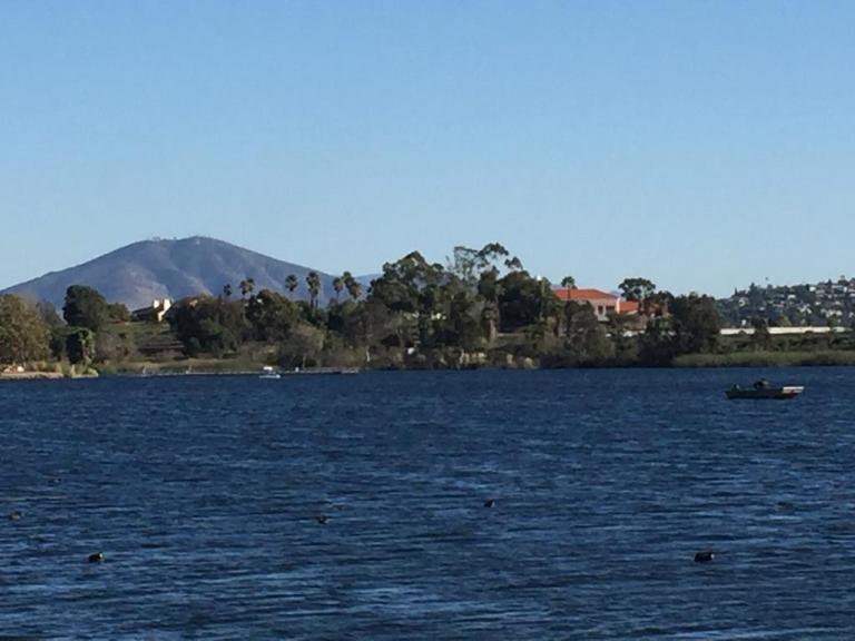
Lovely Lake Murray
Since I didn’t quite get enough enough of a workout / nature fix, I decided to check out alluring Lake Murray Reservoir, also part of the Mission Trails Regional Park. I strolled the paved road that navigates around most of the lake stopping short of the dam (no access). It’s another popular spot – walkers, runners, bladders, and even road bikers aplenty (the latter seems silly to me, because the path / road is only 3.2 mi long and there are many children and dogs on it).
Lake Murray is a great spot for birdwatchers with abundant ducks, geese, and herons abound and about 149 bird species to observe. It’s a pleasant spot for a picnic too.
Go Fish
Lake Murray is open for shore fishing and private boats, kayaks, and float tubes seven days a week from 5:30 a.m. to 8:00 p.m. Permits can be purchased onsite at the iron ranger boxes. The lake is stocked with Florida-strain largemouth bass, bluegill, channel catfish, black crappie, and trout. Minimum size limit for bass is 12 inches.
Fish limits: 5 trout, 5 bass (min. 12 inches), 5 catfish, 25 crappie and bluegill total, no other species limits


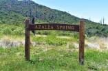 If you reach this sign, refill you water at the spring, but you want to turn back and follow the fireroad about a 1/4 mile to the Coneja Trail connector and take that on up to the peak.