Mt. Biking Noble Canyon, Pine Valley, CA: from Heavenly to Hellacious

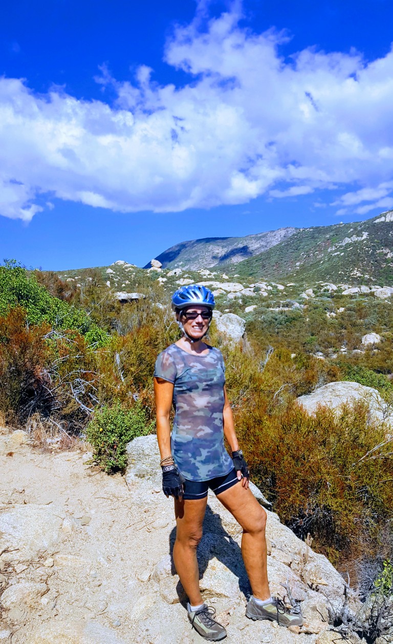
Was gunho to get away to somewhere new this weekend. Perhaps a little too gunho…Wasn’t quite as thorough with the research as I usually am, but had done enough to know that the Laguna Mountain Recreation Area is a great spot for mountain biking and enjoying great scenery as you traverse 3 ecosystems: mixed-conifer/black oak forest, alpine meadows and desert.

And it certainly served up some heavenly single track around Laguna Meadow and beyond.


Sublime, right? And so it went for about 6 miles before things took a gnarly turn for the worse. Scattered rocks, became bulky blocks with jagged edges,  boulders and ankle bashing bruisers galore. I didn’t get pictures of these tortuous areas because, I was too miserable fending off hordes of face flies while hike-a-biking my hefty 35 pound bike. Even if I’d had a Go Pro, you wouldn’t have been able to see beyond the blur of flies – that’s how bad it was. Brutal – yes.

We only saw 2 other mountain bikers on the rough lower portion. They were wearing completely padded body armor suits with full face helmets. Another clue that I was way out of my element…I’m tough, but I’m not technical and have horrible eyesight and depth perception so this it was more than a bit hazardous. I’m extremely lucky to have escaped with only a handful of bruises and scratches.

( I later discovered – post-research – that this area is notorious among mt.bikers and is affectionately called Stairway to Hell and Roman Road.)

Here are a couple links to youtube videos on the area.

We kept looking for a route that would loop us back as a couple people at the trail head had mentioned, but we never found it. And there was no way we were going back up the Stairway to Hell…I even thought of abandoning my beater mt. bike and hiking out even though I only had my bikes shoes.


20170916_144652
A smile (or grimace) of relief after surviving Stairway to Hell

Instead, we made it out to the Pine Valley picnic area and then out the road. Realizing then that we would have to ride up the mountain via Sunrise Highway. Not much of a shoulder there, but a lesser evil than Stairway to Hell. Climbing 8 miles and 3K feet back to the car after the tortuous Noble Canyon was its own purgatory, and certainly, I’ve learned my lesson about doing my research. Perhaps next time, my BF will read the links I send him prior to departure too. (Snarkyness aside – selfreliance is critical even when you’re with a partner. If we both had read the trail reports thoroughly, one of us likely would have retained which trail to loop back on – though we still might not have found it…)

This day certainly put us to the test. Even though we both keep a fairly high fitness level – it kicked our butts. And to both our credits, we didn’t bite each others heads off. I did come close to meltdown with the face flies on attack while I was hefting my bike over boulder after boulder, but I held it together. We both did, taking the punishment mostly in silent, focused suffering. What was going to be a pleasant morning adventure, ended up being a whole day ordeal. Great workout – not so fun.

I’ve reread some of the trail reports and it sounds like there are other options if you want to avoid the burly section of Noble Canyon. I may be back, but need a cooling off period and time for my bruises to heal first.

Where: 40 minutes from downtown San Diego, near Pine Valley, off of Pine Creek Road North of I8 or off of Sunrise Highway to go top to bottom

What: Noble Canyon Trail, Laguna Mountain Recreation Area

Distance: 19.9 Miles out & back

Elevation  gain/loss: 3,346

Rating: For hiking: Moderate. For Mt. biking: Advanced+++

Notes: Adventure Pass required.

Tip: Bring bug spray and plenty of water. Consider a car shuttle for a 10 mile option. Given that it’s single track and a mountain biker destination, it’s not the most peaceful option for hikers…The trail head maps aren’t great, do your research first. ; )

Have you had any small adventures turn into challenging ordeals? Do tell.


Take or leave it, just leave no trace: Los Peñasquitos Canyon Preserve

Location

Between Rancho Peñasquitos and Sorrento Hills to the north and Mira Mesa to the south, near the 5 & 805. The south side entrance is off of Sorrento Valley Boulevard, about a 1 mile east of Vista Sorrento Parkway.

History

Evidence of Native American prehistoric culture within the Preserve dates back as far as 7,000 years ago and apparently remains can still be found.

Apparently the ruins of the El Cuervo Adobe (1857) are at the West end of the Preserve, but somehow I’ve missed it on my half dozen trips here – must not be well marked. Next time, I’ll make a point to find it and update this post.

Flora & Fauna

Surprisingly biodiverse given its urban location, it’s reported that Los Peñasquitos Canyon and its tributary, Lopez Canyon are home to over 500 different plants, 175 bird types of birds, and a large variety of reptiles, amphibians and mammals (raccoons, mule deer, bobcat and coyotes). Many of these are rare or endangered and live a protected life in the Preserves 14 habitat types. From the steep slopes, flat mesa tops and grassy hillsides to the refreshing, shady riparian streams, apparently wildlife flourishes. In my visits here, I have seen little evidence of all the wildlife. No doubt, one would see more on foot at the prime wildlife watching hours of dawn or dusk…

Main Trail – Mild to Moderate

~7 mile loop

Some rutted and rugged terrain with a few climbs, but mostly flat and nontechnical. They’ve put down tons of rough rock on a mile stretch or so of the trail, which is a real pain in the butt (literally)  to traverse on mt. bike. Saw some guy with his young kids on bikes. They made it to the waterfall, but going through that rough rock section was an arduous journey that no doubt made for a very long day. You can avoid that section by taking the parallel trail out and back. Take the short bridge crossing from the starting trail (both directions).

Highlights

The waterfall that springs out of volcanic rock and the 5 bridges that cross the stream and connect either side of the loop trail that runs the length of the park.

This slideshow requires JavaScript.


My Take  

What can I say? When it comes to being immersed in beautiful places, I’m more spoiled than most. That being said, I wouldn’t go too far out of my way for this one. It’s good if you’re in the area and just want to get in a quick trail run, mt. bike ride or leisurely family stroll.  Also, it can be really crowded here with other bikers, hikers, families with small kids and dogs spread across the width of the trail. It always amazes / annoys me when people lack the common sense and courtesy to allow 2-way traffic.


 Warnings

Be on guard for poison oak and rattle snakes. The sign warns of mountain lions too, but highly unlikely in such a small area. Also, it can be super hot here in the summer – avoid the heat of the day.

Note

Trails may be closed intermittently due to flooding, call the county park ranger’s office for status after rains.  (858) 484-7504.


Have you been here? What’s your take? Like it, leave it, or love it?

Mae Wang 3 Day Bike & Trek: Day 1 Cont…

So after a steep climb up a dirt road towards the end of our 3 and a half hour hike, we turned a corner into this elephant sanctuary. It was a complete bonus surprise -not mentioned in the trek description or foreshadowed by our guide.

This slideshow requires JavaScript.

Giddy from these new sights, I was energized to make the last push up the steep, long hill to the  village.  The plan was to participate in the communal food preparation and then spend the night with a family of the Karen Hill Tribe…To be continued…

Mae Wang Bike & Trek Day 1

Tour company: Green Trails    Guide: Tui   My rating: Excellent, highly recommend

After lunch, we drove another hour climbing steadily North alongside a river and happy Songkran celebrants young and old. (Thai New Year Festival is April 13-15.)  Songkran traditions include visiting local temples and offering food to the Buddhist monks and drizzling water on Buddha statues. This water ritual symbolizes the cleansing of one’s sins and bad luck. Paying reverence to ancestors and returning home are also an important part of the Songkran tradition.

The holiday is perhaps best known for its water festival, which is mostly celebrated by the young and young at heart. Basically, it’s a countrywide, good natured water fight.

Traveling in the back of a tourist transport truck we were sitting ducks for playful ambush by hoses, buckets and hopped up water guns from both sides of the road and passing trucks. Unfortunately, I don’t have any pics of this as I didn’t have a waterproof case for my camera. (I do have one for my cell phone so I will try to capture some of the fun  upon return to Chiang Mai.)

We started trekking in the heat of the day. (About 103 F.) My travel buddy Walter and I were on a “join in” tour, but no one else joined so it was our private tour. We didn’t see any other foreigners until the end of the last day.

It was a hot, dry, upward slog. Far drier and a bit scrappier of a trail than I’d imagined. Of course,  April is the hottest and driest month of the year. How hot was it? So hot there were no mosquitoes even along the stream that we followed up to a waterfall. Ahh, what a refreshing reward at the halfway point and an our first  introduction to a couple of Karen tribesmen.

Some of my favorite pics of today’s trek are these of a local at the waterfall and a farmer and his ranch. The crop is peanuts, rotating from rice. I’m using my new Nikkon D3400 for most of these. (My first “real” camera.) Can you tell the difference?

DSC_0115

This slideshow requires JavaScript.

What an incredible experience this is! Up a hill and around the corner, an unexpected surprise…to be continued

Why? Because it makes me feel alive.

I’ve often been asked, “Why climb that mountain, or slog through a grueling hike?” Is it the accomplishment, the vistas, the solitude, the workout, the total immersion in nature? Yes, but more. Doesn’t it get old? No, never.

After a vigorous day hiking the Pioneer Cabin Trail in Big Sky, my partner summed it up when he said, “That was something, I really felt alive.” Later, apparently suffering from fatigue induced amnesia, he asked me if I ever get tired or bored of hiking. I replied, “No, and you know why? It makes me feel alive.” If you’re reading this post, chances are you’re a kindred spirit and you get it. It’s primal, natural and great way to nurture our minds, bodies and spirits. Of course, hiking is not for everyone, luckily the options we have to get physical in the great outdoors are virtually limitless. What’s your favorite pursuit?

What makes you feel alive?