Spent a leisurely morning exploring a few of the wonderful State Parks and scenic reservoirs near St. George, UT.
What’s great about the reservoirs in Utah, is not only are they breathtakingly beautiful, but you’re also allowed to boat, fish, and swim in them.
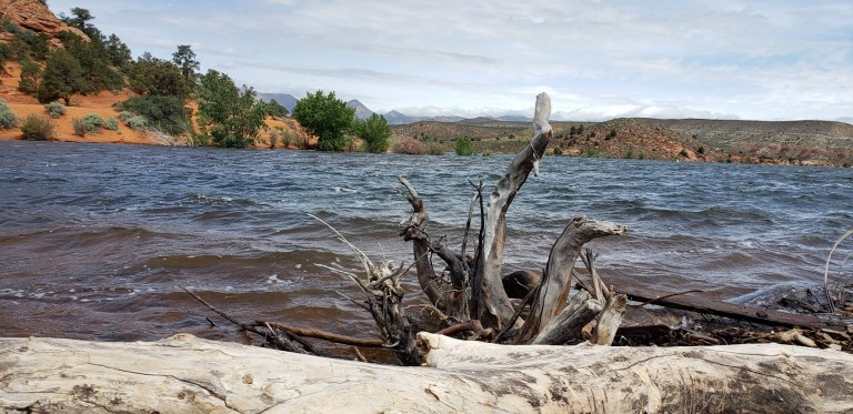
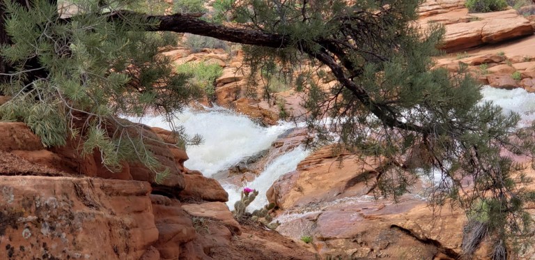
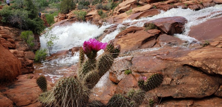
The 66-acre Gunlock reservoir, as you can see from the picture above is overflowing with scenic beauty. (Pun intended.) We heard that the falls haven’t flowed in about seven years so we got a special treat-they’re quite spectacular as you can see. Unfortunately, people have died cliff jumping here so immerse yourself in the beauty wisely. The park is approximately 15 miles northwest of St. George and the dam was constructed in 1970 for irrigation water and flood control.
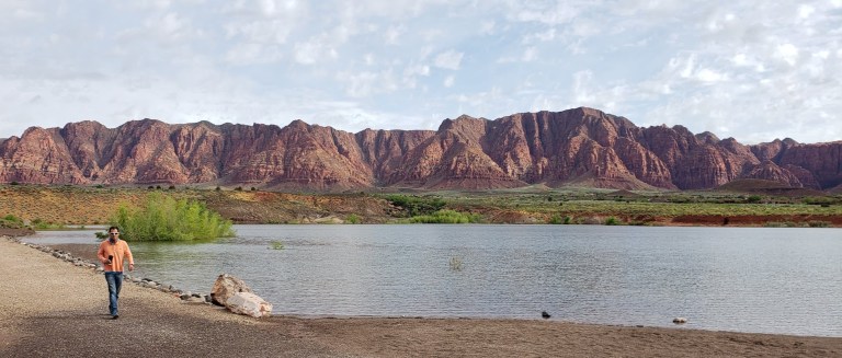
Meanwhile, back in Ivins, enjoying a coffee (not as hard to find in Mormon country as you might think) and a stroll around the reservoir. Ivins is a “bedroom community” of St. George that features its own little reservoir and the dazzling artist’s and retirees’ enclave of Kayenta. They have a coffee shop / restaurant, lovely gardens, galleries, and a theater there. Imaging waking up to this view every morning. In the other direction, a snow capped mountain range. Absolutely gorgeous!
A crown jewel indeed. Point Lobos is absolutely breathtaking. The pristine rugged seascape here is brimming with life. A small park from a hiking trail mileage perspective – about 6 miles total – this park delivers big with stunning, spectacular vistas. Here, you’ll encounter plant communities, archeological sites, geological formations, and the incredibly rich flora and fauna of the jagged landscape and rolling surf. There’s also a whaling museum on site.
Blue Heron MediataionCharming, Secluded CovesThe Carmelite Monastery of the cloistered Sisters by The Sea, a heavenly spot to cultivate spirituality.
Sea Blues by Monastery BeachWildflowers and Wild ViewsPoint Lobos is home to 3 species of trees: the Monterey Pine, the Coast Live Oak, and the Monterey Cypress. The Allan Memorial Grove in Point Lobos is a native stand for the Monterey Cypress, which is listed as a Category 1 rare and endangered species,
This is an absolute must do if you’re in the area. The trails are all quite accessible and you don’t have to go far to feel like you in the midst of the coastal wild. If you’re like me, you won’t want to leave. It’s a mesmerizing, magical place. (It’s like California before man.) We are so fortunate to have this area preserved. So grateful to the Point Lobos Foundation for protecting this natural wonder and national treasure. A great destination for nature lovers, painters, photographers, poets and all artists and pantheists alike. (The foundation actually puts on a poetry walk / Haiku hike- how cool is that???!)
This is my bliss. Soaking in the natural beauty as I channel Copenhagen’s Little Mermaid.
Given that Point Lobos State Marine Reserve is one of California’s richest marine habitats, it is a scuba diver’s, snorkeler’s, kayaker’s, stand-up paddler’s paradise with 70 foot kelp forests brimming with lingcod, rockfish, harbor seals and sea otters.
Diving is allowed only at Whalers and Bluefish Coves. Proof of certification is required. Reservations are recommended for the weekdays and are a must for weekends and holidays.
Stand-up-paddle and kayaking are also allowed in the Reserve. (There’s a $10 fee to launch from Whaler’s Cove. You can also launch from Monastery Beach, 1/4 mile north of the park.) This would be an exceptional way to explore the captivating coves and coastal. Surprised I didn’t see anyone kayaking or stand-up paddling here; it was a perfect day with glassy calm water. Next time, I’m going for a SUP tour of my own. And yes, there will be a next time, because once you visited, all you can think about is going back.
Notes:
Poison oak flourishes here and is everywhere. While the park does its best to keep the trails clear and rope off areas, they can’t keep up with the robust growth. Pants and long sleeves are recommended. Keep an eye on young children with wandering hands…
No pets allowed in the reserve or left in parked cars.
Keep a minimum 50 feet away from marine mammals.
Dangerous conditions, including rip currents occur – be ocean-wise and safe.
Hours: 8AM-7PM
Address: 62 California 1, Carmel-By-The-Sea, CA 93923
Fees: You can park and enter for free via Coast Highway (their small parking lot is often full), otherwise it’s $10 to park, $5 for Seniors & Disabled.
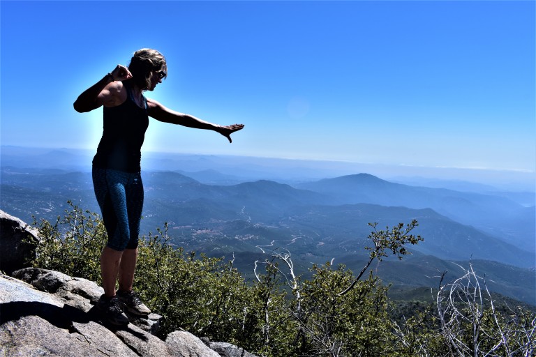
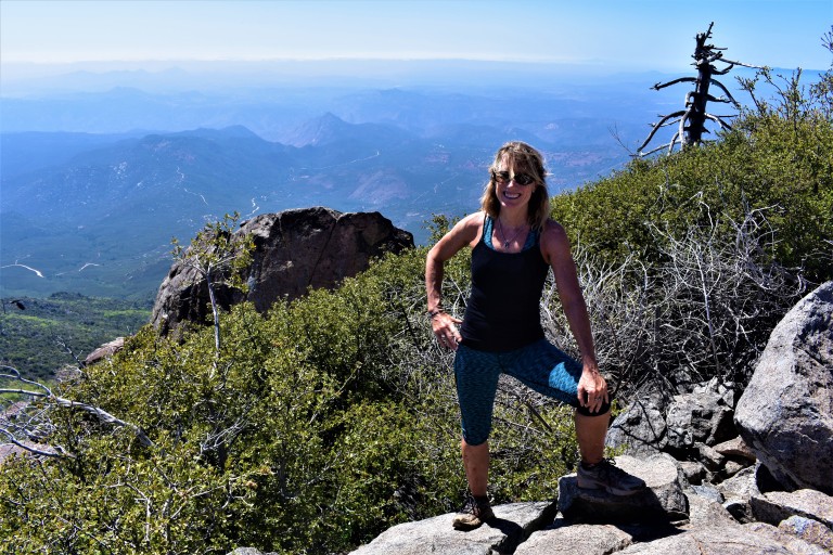
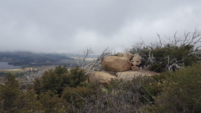
Cuyamaca Peak‘s little sister, Stonewall Peak, (5,730 feet) outshines her big sister with her stunning granite crown, haunting tree skeletons (remnants of the Cedar Fire) and lovely vistas of Cuyamaca State Park and out to Anza Borrego. Before I moved to North County and started exploring the area, I had no idea that all this wonderful natural beauty is an easy drive from greater San Diego.
Gradual ascent on a friendly trail
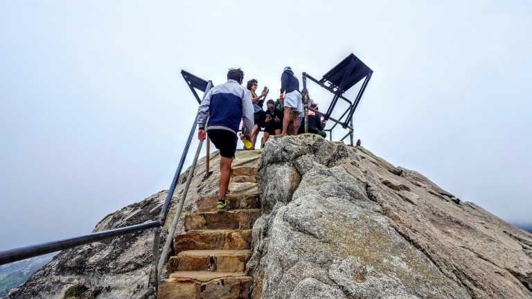
Expansive viewsInteresting rock formations along the wayStairway to heavenly vistas
Something about these beautiful trees and bouldersA bit crowded at the actual peak – silly people looking down at their phonesLovely Lake Cuyamaca views on the way downA sprinkling of dazzling wildflowers
Takes you back to the start
Biggest Dandelion Ever???
Planning your Cuyamaca adventure
You can make it a day or a weekend adventure and do as much or as little hiking as you like. Ambitious, fit hikers can take on both peaks (Cuyamaca & Stonewall) in a day. For the less ambitious, there are plenty of opportunities to add on easy short strolls by the lake and up to Stonewall Mine. Lots of wildlife viewing with trails for the whole family. Stay tuned for my next post. Happy trails!
The historic gold mining town of Julian is a mile or two away with its quaint shops, B&Bs, restaurants and famous pies.
Notes: This is the most popular hike in the park so go early to avoid the crowds. After you reach the Stonewall Peak spur trail and make a right, there’s a really short scramble over some rocks before you hit the last rocky stairway. Keep your eyes open for the metal handrails. On the way back, I recommend taking a right at the junction for a different route down ton what becomes a pleasant single track trail d. At about 3.7 miles, you come to a trail intersection. Make the left onto Vern Whitaker Trail. Shortly after that (around 3.9 miles) there’s another junction, continue to stay left. At 4.2 miles or so,you’ll encounter another side trail; stay your course to the left again.
Miles: ~<4 miles rt if you just go up and down the main trail. My scenic route adds about a mile & a half for ~5.5 miles rt.
Elevation gain: 1,050 feet
Terrain: Mostly sweet, clear terrain (as in trail runnable). It’s gets a bit rocky and pesky for a while near the top so watch your footing. .The single track down was mostly friendly.
Difficulty: Easy to moderate. Depends on your fitness level and the route you take.
Trailhead: Across the street from the Paso Picacho campground, Cuyamaca State Park
Parking: $10 State Park Fee
Dogs: Only allowed on paved roads and must be leashed.
Camping: Paso Picacho campground has family campsites with tables, firepits, running water and bathrooms.
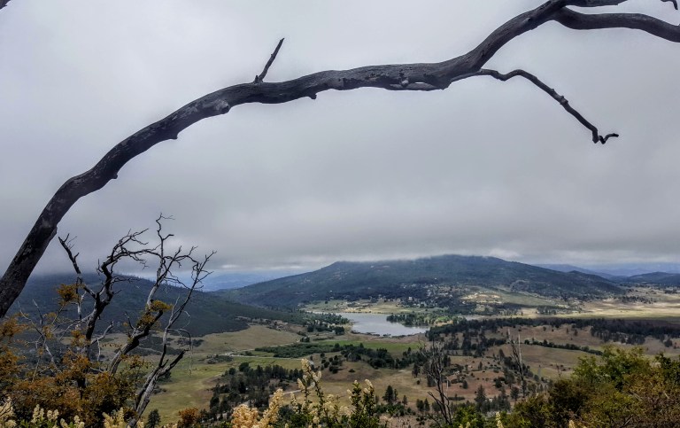
It’s relatively easy to “bag”the second highest peak in San Diego County as it tops out at just 6,515 feet. You’ve got a choice between two routes or a combo of them. I opted for the scenic trails up and took the paved road down to make a loop. Views were good on both routes, but far more solace, solitude and wildflowers on the less traveled, natural trail.
In 2003, the Cedar Fire , California’s biggest wildfire (started by a lost hunter who lit a signal fire that burned out of control) decimated 290, 278 acres, including 90% of the Park’s 24,700 acres. The ravages from that fire are still rampant, but these formerly rich forest (oaks, willows, adlers, and sycamore tress, cedar, white fir, ponderosa, Coulter, sugar and Jeffrey pine) and meadowlands are slowly making a comeback. More than 100 bird species abound in the park, including acorn woodpeckers, northern flickers and red tailed hawks, Mammals you might encounter here include gray fox, badger, bobcat, mountain lion and deer.
Azelea Glen Loop Trail
If you reach this sign, refill you water at the spring, but you want to turn back and follow the fireroad about a 1/4 mile to the Coneja Trail connector and take that on up to the peak.
At the top
Unfortunately, it wasn’t a clear day so the Salton Sea and Anza-Borrego Desert to the east and Pacific coastline to the west and all the mountain vistas surrounding were a bit difficult to discern.
Is it just me or does the burnt tree in the picture above evoke an Indian chief bowing his head? (Kumeyaay Indians occupied the Cuyamaca mountains from antiquity until around 1857.)
You can document your peak bagging effort by opening this box and signing in.
Views to Lake Cuyamaca and the Valley belowA framed view of Stonewall PeakA closer view of Stonewall Peak
There are plenty of other trails to explore nearby including a switchback trail up and down alluring Stonewall Peak (4 miles rt) and hidden waterfalls somewhere…(I’ll let ya know when I find them.) If I’d had more time I would have done Stonewall too. (The trail head is right across the campground entrance.) There’s more than a 100 miles of trails for hiking, horseback riding and a select number for mountain biking here. I’ll be back.
Planning your excursion
You can make a day or a weekend of your Cuyamaca adventure. The historic gold mining town of Julian is a mile or two away with its quaint shops, B&Bs, restaurants and famous pies.
Notes
Miles: 7.7 miles rt (Or just 5 miles rt if you take the paved road both ways.)
Elevation: 1700 ft gain/ loss
My route: Azelea Glen Loop to Azalea Glen Road. Make a right on the Azalea Fire Road, a left on the single track Conejo Trail that comes up in a 1/4 mile. The Conejo Trail hooks up with Lookout Fire Road about a 1/2 mile from the top – the steepest portion.)
Terrain: Mostly sweet, soft terrain (as in trail runnable), until you get to the Conejo Trail. It’s gets a bit rocky and pesky for a while on there so watch your footing. (Another reason I chose the paved road downhill.)
Difficulty: Moderate. Depends on your fitness level and the route you take. The 1/2 mile incline at the top is tough, but it’s all quite reasonable. I brought hiking poles but did not bring take them on the trail and was fine. (I have bad knees.) It would be a bit relentless to take the paved road up. (I wouldn’t mind trying it on a mtb bike. Heard about some people who did on road bikes – that’s a little nutty. Took me 2 hours up and 40 minutes down – no running…
Trailheads: Both the paved Lookout Fire Road & the Azelea Glen Loop begin at the Paso Picacho campground, Cuyamaca State Park
Parking: $10 State Park Fee
Dogs: Only allowed on paved roads and must be leashed.
Camping: Paso Picacho campground has family campsites with tables, firepits, running water and bathrooms.
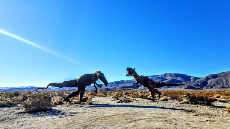
Thanks to the owner of Galleta Meadows Estate, Dennis Avery, there’s an incredible al fresco metal art sculpture exhibition to be discovered in Anza Borrego. Over 130 metal sculptures created by artist/welder Ricardo Breceda seem to appear out of nowhere in the barren, dramatic landscape. With a little imagination, you’re transported to the prehistoric times of dinosaurs, mastodons and saber-tooth tigers.
The exhibition spans about 10 square miles. Many of the sculptures can be seen from the road; others require some driving, hiking or mountain biking in on sandy roads. Some are in clusters, others quite spread out. You never now what kind of creature you’ll encounter next. Highlights include a giant scorpion, a 350 foot-long sea dragon and so many more. I’ll leave you to discover the rest yourself. My favorites, as you can tell, were the prehistoric sculptures.
It’s definitely worth seeing and no doubt a blast for the kids.
Getting there: Take the S22 into Anza Borrego and cruise the valley looking at both sides of the road. (If you want a guided map for the sculptures, you can pick one up at the visitor center in town.)


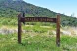 If you reach this sign, refill you water at the spring, but you want to turn back and follow the fireroad about a 1/4 mile to the Coneja Trail connector and take that on up to the peak.