Washington’s Beacon Rock Trail: a shortie with sweet views

Geological origins

According to some experts, Beacon Rock or  Che-Che-op-tin, which means the navel of the world, is the second largest, free-standing monolith in North America.  (Supposedly approaching the ranks of El Capitan, Devils Tower, Uluru/Ayers Rock, and other notables.) Composed of Basalt, it is the core of an ancient volcano. Through the ages, massive floods carved their way through the Columbia River Gorge and through the volcano, leaving only the core of Beacon Rock in their wake.

The trail

The Beacon Rock Trail was built directly onto the side of the rock, and ascends to the top of the rock (850’ elevation) by way of 52 switchbacks. Along the way there are sparkling panoramic views of the Columbia River Gorge, the Bonneville Dam, and the Pierce Wildlife Refuge. The “peak” area is small and doesn’t offer much in the way of scenery. It’s a short and relatively easy ~1.6 mile out and back with a 680 foot elevation gain. There’s  a fair amount of traffic as it’s right off Highway 14, perfect for a quick run up and down. (Of course, I happened to hit it at high noon on Washington’s hottest day in a record-breaking heat wave. Dangerous for pets or anyone not up to extreme temps.)

The story behind the trail

The story goes that the United States Army Corps was going to cannibalize the rock for material to build a jetty at the mouth of the Columbia River. In 1915, philanthropist, Henry Biddle, bought the rock for $1, and together with Charles Johnson, built the trail over the next 3 years. After Biddle’s death, the family offered to make it a state park. Washington initially declined, but accepted the offer after Oregon expressed interest.


Details

Located near Stevenson, WA off of Highway 14

Discover Pass must be purchased and displayed in your car.


Mt. Hood, Oregon: Timberline / PCT Trail & Paradise Found

Got a late afternoon start so we set out for a quick, couple mile out and back on the Pacific Crest Trail (2000) also known as Timberline trail (600) behind the historic and grand Timberline Lodge. However, the Paradise Loop trail (757) marker about 4 miles in was too tempting to resist with its wildflower-sprinkled meadow and snow-crowned Mt. Hood in the distance.

Round trip distance : ~12 miles                 Elevation gain: ~2,300 feet            Scenery: Oh, my!

Rating: Difficult (Length  & areas of incline)     Terrain: Easy (Running shoe-friendly.)

Not that the first 4 miles wasn’t scenic too. Views of Mount Jefferson and the Three Sisters to the south accompany you along the way. And you pass several streams (waterfalls in other seasons), and impressive Zig Zag Canyon too.


This slideshow requires JavaScript.

This was an all-around stunning hike and a great workout too. Exhilarating and breathtaking in every sense of the word. I’ve always wanted to take the Timberline Trail around the circumference of Mt. Hood. (It’s a 38.4 mile hike with 8k  elevation gain.) There are some ultra-runners who do it in a day. Most make a 3-5 day trip of it. There may be a return trip in my future. Will I be able to resist Paradise Loop next time? Probably not.

And now for a refreshing cocktail followed by a delectable feast and a luxurious night at my top pick Timberline Lodge.

Sun Valley, ID: Pioneer Cabin Hike

Tremendous hike in Sun Valley. Rewarding views, great workout, super cool cabin.

Distance: 8.5 miles                  Rating:  Difficult            Elevation gain: ~2,550 ft

Took the steady climbing Pioneer Cabin trail #122 up and descended the loop via the Long Gulch trail #123. Minus the snow and ice on the top and down the backside that we encountered, this would be a fantastic trail run. The terrain on 122 is pine needle smooth as you traverse 23 switchbacks through an old growth forest with glimpses of the Pioneer, Smoky, and Sawtooth Mountains through the trees. As you continue up into high alpine meadow, you’ll be rewarded with sweeping views .


But you’re not quite there yet. Just one more push and a panorama of peaks opens up and a rustic cabin welcomes you.

Pioneer Cabin was built by Sun Valley Company in the 1930’s to encourage Alpine skiing. (If I’d known the cabin was open, I would have made it an overnighter.) Underneath the snow, emblazoned on the roof greeting all those who ascend to its heights is its signature quote “The Higher You Get, The Higher You Get.”


Unlike trail#122, 123 is a bit tortuous, very rocky the last 2 miles or so.  Not to mention all the snow we encountered on that trail, but it was all so worth it! This hike makes most people’s list for the top ten in Sun Valley. It’s certainly tops with me.


Yellowstone quickie: Biscuit Basin, Mystic Falls & overlook hike

Wonderful to be in Yellowstone without the crowds. Unfortunately, only had time for a short hike so opted for Mystic Falls – that way I could take in the geological wonders at Biscuit Basin first with the added  bonus of a waterfall and vista of the Upper Geyser Basin.

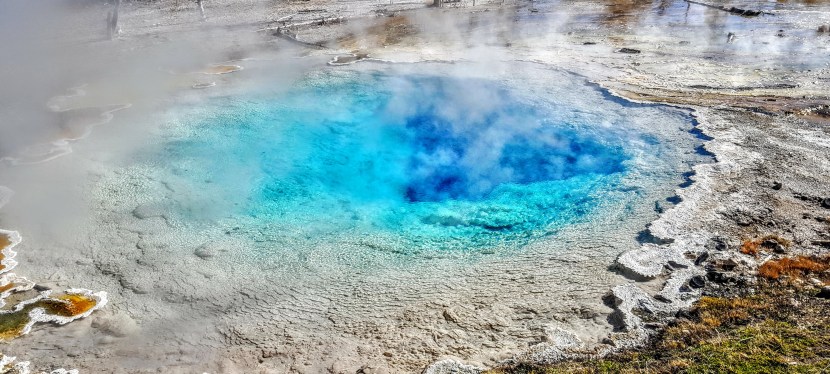
Silex Spring, the photo at the top of the page, was one of the most spectacular geothermal pools, but there were many contenders. It was mesmerizing to watch what seemed to be sporadic eruptions from pool to pool. After  a while, you notice that the eruptions are actually sequential with the water draining from one pool and filling the next.

Read more →