This video captures the inhospitable side of Alfie’s personality as he summarily dismisses a visitor to his cat cave condo.
Alfie is demanding more air time…His lion-size ego is getting out of control.
This video captures the inhospitable side of Alfie’s personality as he summarily dismisses a visitor to his cat cave condo.
Alfie is demanding more air time…His lion-size ego is getting out of control.

I can be all about roughing it, but I do like to mix in a bit of luxury too (especially as a grand finale). After the hiking the Paradise Loop trail, I found a slice of heaven at the historic Timberline Lodge. Constructed of native timber and stone, the exquisitely crafted lodge was built during the depression era as part of the Franklin D. Roosevelt’s Works Progress Administration (WPA) program between 1936 and 1938. Read more
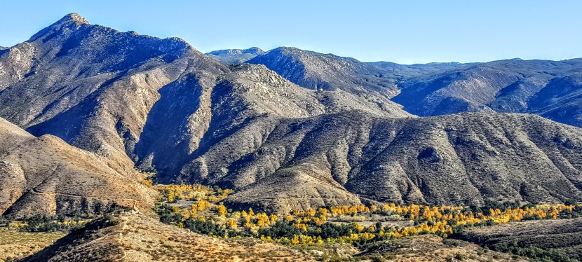
My expectations for the Cedar Creek Falls Trail were low as I’d read about crowds and litter here. Hiking in the off-season has it’s perks – no crowds and no litter – yay! (The trade off, just the damp shadow on the rock tracing where the 80 foot water fall flows.) Otherwise, I was very pleasantly surprised. The terrain is perfect for trail running if you can handle a consistent ~ 2 mile descent, followed, of course, by the consistent ascent. My knees can’t take the downhill anymore, but I sure enjoyed the run back up.
In the summer the temps can climb to 115 degrees so heat stroke and dehydration are concerns. Not the place to take your pooch or that friend who hasn’t worked out in recent memory – there have been several deaths. Also, people have been seriously injured for jumping off the rock into the shallow pool (duh). Those who live in this area of Eastern San Diego are accustomed to the hum of helicopters flying in to pick up the pieces. There were some cross country high-school boys risking it while I was there. Showing off for their girlfriends. Boys will be boys and survival of the smartest applies here.
Distance: 6 Miles Round Trip for this out & back
Rating: Moderate to easy if you are in shape, difficult otherwise
Permit needed.
Waxing nostalgic…When I was a kid, my Mother used to hand my brother and me the Sears Christmas Wish Book. She’d give us both magic markers and tell us to mark everything we wanted Santa to bring us for x-mas. We spent hours mesmerized by the glossy, colorful 600 page tome, poring over 200 plus pages each bursting toys galore. Even after we knew that Mom was Santa, there was still a certain sense of excitement every year as we huddled together over those dazzling pages.trying not to circle every toy. It was so hard to decide. Once the presents were delivered, we were always confused. We didn’t recall circling Yahtzee, or Rack-O…Later, we realized it was just one of our Mother’s schemes to keep us occupied for endless hours.

Today, do parents send their kids to the web to create their wish list shopping carts? For fun, I went window shopping online at Amazon and “circled” some items. I’ll start with some stocking stuffers and keep adding as I browse and hear back from you. What’s the best travel adventure gift you’ve ever received? And what’s on your wish list this year?
Stocking stuffers
$5 and under
 The Mad Libs WORST CASE SCENARIO Survival Handbook: Travel Fun for all ages on a road trip, in the tent, or by the campfire. : )
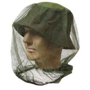
Sure wish I had this when I was hiking in Yosemite. The face flies were so brutal I nearly turned back. Other hikers did. Luckily, once you get above 8k feet they drop off. This could be the best $2 bucks you’ll ever spend.
$10-$20
 TECH-P 5 in 1 Multifunctional Paracord Bracelet with Compass Flint Fire Starter Scraper Whistle Your mom would want you to have this survival bracelet.
 LifeStraw Personal Water Filter Your mom would want you to have this one too. Warning, this does not does not filter out viruses, but is good in a pinch.
 Kalily Headband Bandana 16-in-1 sports & casual headwear with UV protection.Be sporty and stylish, even with sleeping bag head.
 Foldable, Ultra Lightweight Packable Backpack
Handy for travel and day hikes
 Waterproof Headlamp with rechargeable batteries, AC charger and car charger
I prefer the one without the holster. Ideally, you should have it on the ready and carry it in your hand.

Mosquito Net for 1 sleeping bag I really enjoy camping out under the starts without a tent. Unfortunately, so do the bugs. Here’s a solution.
Other ideas
Gift certificates to their favorite outdoor store
Airline tickets or points
State Park Passes

Geological origins
According to some experts, Beacon Rock or Che-Che-op-tin, which means the navel of the world, is the second largest, free-standing monolith in North America. (Supposedly approaching the ranks of El Capitan, Devils Tower, Uluru/Ayers Rock, and other notables.) Composed of Basalt, it is the core of an ancient volcano. Through the ages, massive floods carved their way through the Columbia River Gorge and through the volcano, leaving only the core of Beacon Rock in their wake.
The trail
The Beacon Rock Trail was built directly onto the side of the rock, and ascends to the top of the rock (850’ elevation) by way of 52 switchbacks. Along the way there are sparkling panoramic views of the Columbia River Gorge, the Bonneville Dam, and the Pierce Wildlife Refuge. The “peak” area is small and doesn’t offer much in the way of scenery. It’s a short and relatively easy ~1.6 mile out and back with a 680 foot elevation gain. There’s a fair amount of traffic as it’s right off Highway 14, perfect for a quick run up and down. (Of course, I happened to hit it at high noon on Washington’s hottest day in a record-breaking heat wave. Dangerous for pets or anyone not up to extreme temps.)
The story behind the trail
The story goes that the United States Army Corps was going to cannibalize the rock for material to build a jetty at the mouth of the Columbia River. In 1915, philanthropist, Henry Biddle, bought the rock for $1, and together with Charles Johnson, built the trail over the next 3 years. After Biddle’s death, the family offered to make it a state park. Washington initially declined, but accepted the offer after Oregon expressed interest.


Details
Located near Stevenson, WA off of Highway 14
Discover Pass must be purchased and displayed in your car.
Adventures Near & Far, St. George Yoga & Hike Retreats, Popup Yoga, Local Guiding
the blog of Seldom Seen Photography
The more we travel the bigger the world gets
Engaging audiences and delivering results
Adventures Near & Far, St. George Yoga & Hike Retreats, Popup Yoga, Local Guiding
Travel. Climbing. Characters. True stories, well told.
memoir, poetry, screenplay, commentary
Photoblog of Joshi Daniel
Adventures Near & Far, St. George Yoga & Hike Retreats, Popup Yoga, Local Guiding
Adventures Near & Far, St. George Yoga & Hike Retreats, Popup Yoga, Local Guiding
Live vigorously! (Not vicariously.)