Pine Valley Butt Kicker Rewards With Spectacular Views

Difficulty: Butt Kicker/ Great Workout!

Elevation Gain: 3,491ft

Starting elevation: 6, 900ft 

Total Distance: 9.35 Miles

Looking for a great foresty hike that will challenge you and then reward you with spectacular views? This is it. Basically, stumbled upon it in search of another trail. It’s a bit rugged / rocky so hiking shoes are a must. Also, you’ll want to stay alert as you slog steadily up or stumble slowly down, there are a couple points where it’s relatively easy to lose the trail.

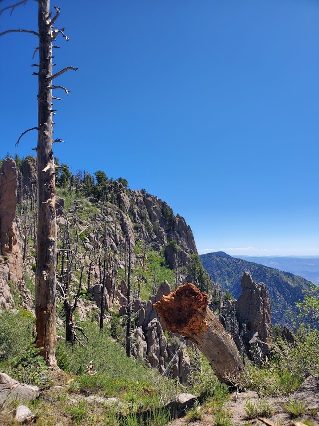
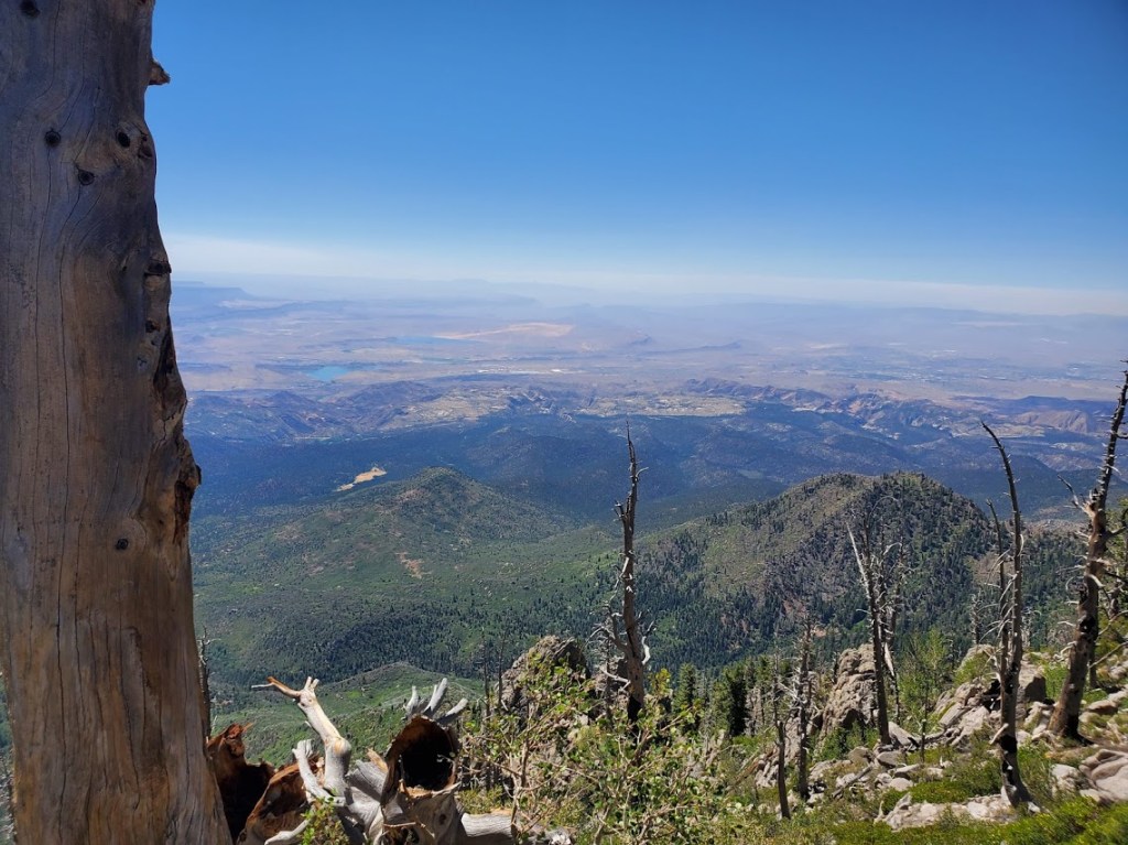
The route I followed was the Brown’s Point Trail to the Summit Trail. (A bit confusing as the so-called summit trail descends at one point and never reaches a summit.) Almost turned around at the next junction, but decided to check out the “Oak Grove Trail” another ½ mile or so up another rise. Well, it was absolutely worth it as there was a spectacular summit view. (Didn’t really notice an oak grove, but definitely noticed the panoramic view.) Target the top if you do this hike –enjoy the panoramic views from 10K ft as far out as 47 miles to Quail Creek and Sand Hollow in St. George / Washington area. The pictures don’t begin to do it justice!

Follow the first paved road to the right BEFORE you pass the entrance gate to the Browns Point Trail head and parking.  

Scouting Scout’s Cave, Snow Canyon, St.George, UT

Distance: 5.5 miles Round trip

Difficulty: Easy, but there is another option via Paradise Rim that’s a little more rugged / interesting.

stairway to heaven
Stairway to heavenly views

Great hike, cool cave, splendid views!

Not a bad spot for a little yoga practice too.

Need I say more? I think not. If you’re in the area for a limited time, this is a good one for your “to do” list.

Getting there: Snow Canyon State Park, Ivins’ entrance. The trailhead is on the right before you reach the park gate. Park in the lot on the left. If you’d like a little more challenging / rugged approach, you can take Lakota Drive to the trailhead for Paradise Rim and come in from the backside. You can also add on a couple miles (~2 each way) if you park at the Chuckwalla parking lot and take the Turtle Rock Trail to connect to the Paradise Rim trail. Anyway, you go, you can’t go wrong.

A little more choppy and a little more climbing on the Paradise Rim Trail

going back up Scouts Cave

Wandering the Whipple Valley Trail, Pine Valley, UT

Distance: 12 miles round trip

Elevation gain: 2,776 Feet

Difficulty: Moderate due to elevation gain & distance

A trip to the mountains is closer than you might think. From St, George. Pine Valley is a mere 30 miles away, but it’s worlds away in so many ways—at an elevation of 6,800, the temperature averages a refreshing ~20 degrees less than St. George.

Indeed when you enter picturesque, historic pine valley, you have arrived at an entirely different ecosystem. Mountain scenery and the Dixie Mountain Forest greet you.

If you’re looking for a wonderful hike in the woods and a solid workout, the Whipple Valley Trail will not disappoint. (It could more apply be named the Switchback Trail.) The single track trail terrain is running shoe friendly and will challenge your fitness level with a gradual, but insistently, consistent climb. At the beginning and end of the hike, you’ll be treated to the nature’s soundtrack of a gurgling stream.

Views of Pine Valley from the trail are lovely and Whipple Valley is delightful. I’ll admit the valley felt incomplete to me as I found myself yearning to take a dip in an alpine lake. (Yes there’s the reservoir back at the campground and I could have soaked my feet in the stream on the way back, but that’s just not the same.)

This slideshow requires JavaScript.

While I found the hike enjoyable and a great workout, I’m not sure I would do it again. This spoiled hiking snob found the views a bit repetitive and the hike a bit long for just a pretty valley reward. If you’ve got mountain fever and need some relief from the heat, this Pine Valley hike is a perfect fix.

You can continue the journey from the Whipple Valley juncture, perhaps I’ll explore those options from another starting point on another day.

trail sign

Getting there: From St. George take the 18N and follow the signs for Pine Valley. Hike starts near the back of the campground.

Snow Canyon Red Mountain Trail Keeps Me Coming Back for More, Dammeron Valley, UT

Why? For the stunning views of Snow Canyon and Pine Mountain, the colorful wildflowers sprinkled along the trail, and the vast horizon!

Distance: 12.1 out and back. Note: This hike takes longer than the mileage would have you expect due to the varied, ornery terrain.

This slideshow requires JavaScript.

The first mile and a half of the initial approach from Red Mountain Trail is forgettable. And it should be noted that for the duration of the hike, you’ll be slogging through rocks and dirt, deep sand, some slip rock, and more deep sand. If you persevere to the Snow Canyon Overlook – just about 2.5 miles in, you’ll be rewarded by unforgettable views – ranking among the best in Southern Utah some say.

The first time, I did the hike I had to turn around near the first overlook. The 2nd time, I made it a couple miles further, but had to turn around because night was descending and I didn’t have my head lamp. Walking through rocks in the dark, not recommended.

Will I do again? Most likely–the views are stunning, it’s close by, and I’m stubborn. I’d like to make it over to the Ivins’ side just to take in that view. And yes, I could start there and do the scramble, but I’m notorious for walking off obvious trails, so probably not prudent. TBD, I’ll post an update on my next visit.

Getting there: You can start this hike from the bottom at Ivins or from Dammeron Valley off the 18N. The Ivins’ way is the hard way for several reasons—it’s a straight up scramble with few trail markers. Rescues happen often here.

Since the Dameron Valley trailhead – Red Mountain Trail is just down the street from me, I defaulted to that–I love climbs, but am not into risks that could take me out the game.

Exploring the Anasazi Trail, Ivins, UT: Panoramic views, petrogylphs, and ancient ruins

Highlights: Spectacular red rock and Santa Clara River gorge views with the bonus of petroglyphs and ancient ruins.

Getting there: The trailhead is just off old US highway 91, near gorgeous Ivin’s reservoir so you can take a dip after your hike. Just look for the Anasazi Trail sign.

Difficulty: Easy, it’s a gradual incline and a short hike that’s suitable for the whole family. Terrain is mostly easy footing, but entirely exposed so plan accordingly and bring plenty of water, a  hat, and sunblock.

The main trail takes you by 1,000 year old remnants of an ancient Indian farmstead, through the petroglyphs, and up along the rim of the Santa Clara River gorge.

This slideshow requires JavaScript.

Length: The main trail is a 2.9 mile loop, but there are many more spur trails to explore that traverse the ridge and valleys.

Free entry. Mountain bikes and leashed dogs allowed.